Jayyous
| Jayyous | |
|---|---|
| Other transcription(s) | |
| • Arabic | جيوس |
| • Also spelled | Jayyus (official) |
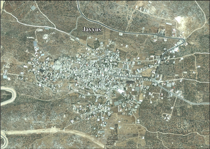
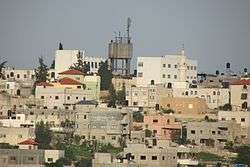 Jayyous, 2016 | |
 Jayyous Location of Jayyous within Palestine | |
| Coordinates: 32°12′05″N 35°02′06″E / 32.20139°N 35.03500°ECoordinates: 32°12′05″N 35°02′06″E / 32.20139°N 35.03500°E | |
| Palestine grid | 153/178 |
| Governorate | Qalqilya |
| Government | |
| • Type | Village council |
| Elevation[1] | 188-233 m (−576 ft) |
| Population (2006) | |
| • Jurisdiction | 3,300 |
| Name meaning | Jiyus, personal name[2] |
Jayyous (Arabic: جيوس) is a Palestinian village near the west border of the West Bank, close to Qalqilya. It is a farming community. According to the Palestinian Central Bureau of Statistics, the village had a population of approximately 3,307 inhabitants in 2006.[3]
Location
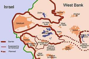
Jayyus (including Khirbet Sir) is located 7 kilometers (4.3 mi)-9 kilometers (5.6 mi) northeast of Qalqiliya. It is bordered by Baqat al Hatab and Kafr Laqif to the east, Kafr Jamal, Kafr Zibad and Kafr ‘Abbush to the south, ‘Azzun ‘Izbat at Tabib, An Nabi Elyas and ‘Arab Abu Farda to the west, and the Green Line to the north.[1]
History
At Khirbet Sir, just east of Jayyous, two rock-cut tombs have been found, with a large mound with terraces cut in the sides, and a good well below.[4] Byzantine ceramics have also been found.[5]
Ottoman era
Jayyous was incorporated into the Ottoman Empire in 1517 with all of Palestine, and in 1596 it appeared in the tax registers as being in the Nahiya of Bani Sa'b of the Liwa of Nablus. It had a population of 24 households and 6 bachelors, all Muslim. The villagers paid taxes on wheat, barley, summer crops, olive trees, occasional revenues, goats and/or beehives; a total of 11,746 akçe. Half of the revenue went to a Muslim charitable endowment.[6]
In 1838, Robinson noted the village, called Jiyus, as being in the Beni Sa'ab district, west of Nablus.[7]
In 1882, the Palestine Exploration Fund's Survey of Western Palestine described Jiyus as a "moderate-sized stone village on a ridge, with olives to the south-east. It appears to be an ancient site, having rock-cut tombs and ancient wells."[8]
In the 19th century and early 20th century the village was dominated by the Palestinian el-Jayusah or Jayyusi clan.[9]
British Mandate era
In the 1922 census of Palestine conducted by the British Mandate authorities, Jaiyus had a population of 433, all Muslims,[10] increasing in the 1931 census to 569, again all Muslim, in a total of 147 houses.[11]
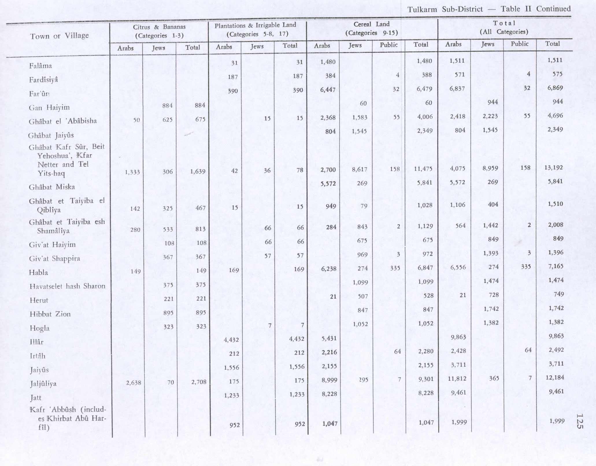
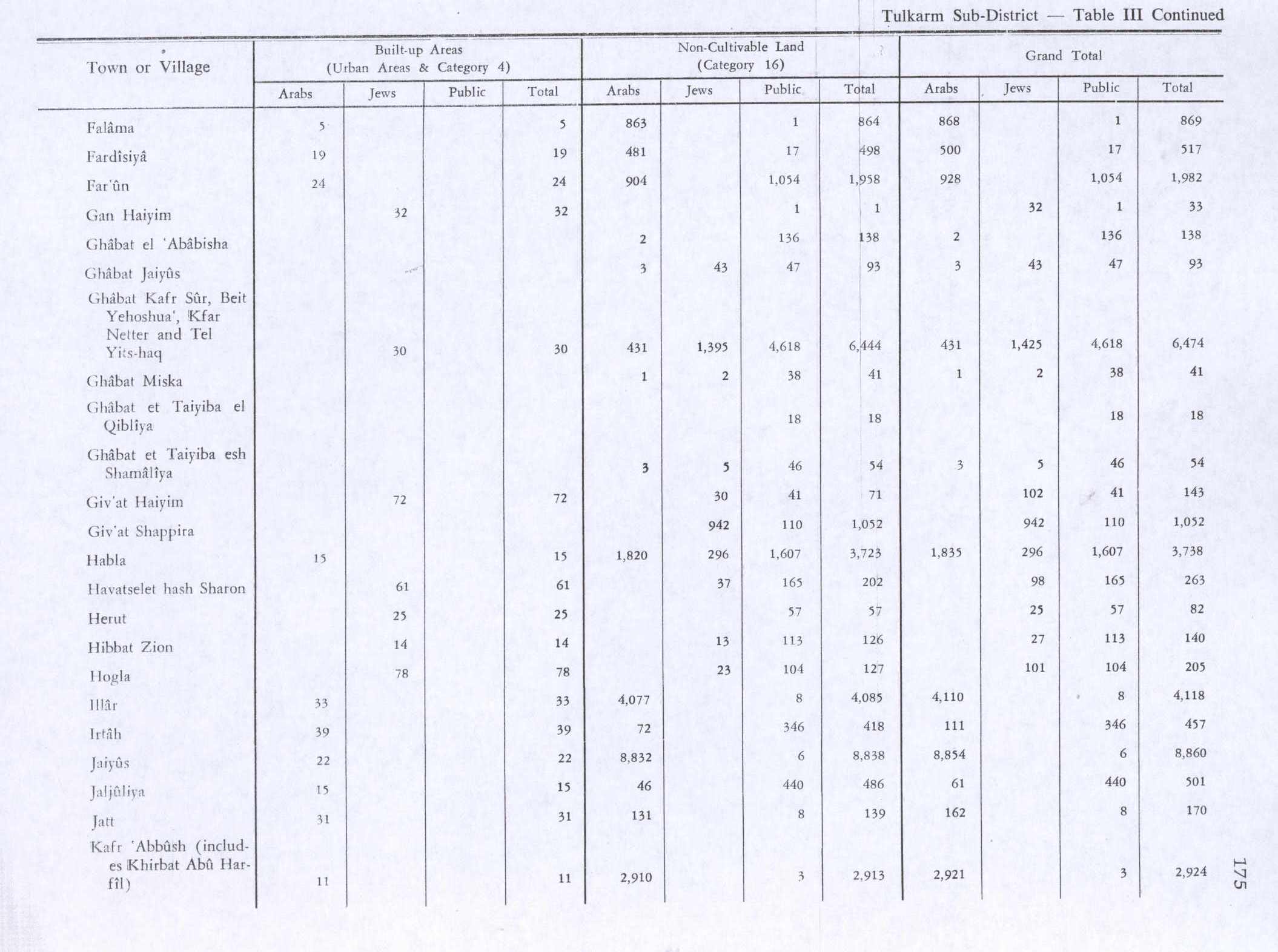
In the 1945 statistics the population of Jayyous consisted of 830 Muslims[12] with a land area of 12,571 dunams according to an official land and population survey.[13] Of this, 1,556 dunams were designated for plantations and irrigable land, 2,155 for cereals,[14] while 22 dunams were built-up areas.[15]
Jordanian era
In the wake of the 1948 Arab–Israeli War, and after the 1949 Armistice Agreements, Jayyous came under Jordanian rule.
Post-1967
After the Six-Day War in 1967, Jayyous has been under Israeli occupation.
After the 1995 accords, 26.6% of Jayyous land is defined as Area B land, while the remaining 73.4% is defined as Area C land.[16]
The village is located in an area directly affected by the Israeli-built barrier and around 75 per cent of the village's farming land is on the other side of the wall.[17] In order to get to their land the farmers need to use one of two gates, North gate or South gate, or gates number 943 and 979 respectively. The two gates are supposed to be open for three short periods a day. In June 2005, the gates were usually closed, and farmers were staging regular protests at the gates. As of February 2007, the gates are open for only three hours per day - one hour each morning, afternoon and evening on average.
In 2002, Jayyous became the first village to mount a non-violent campaign with Israeli and international participation against the construction of the wall and the expansion of settlements on its land.[18] According to The Financial Times, 50 percent of the once-prosperous Jayyous villagers are now dependent on foreign food aid because their agricultural land has been cut off by the wall.[19] In January 2005 Ta'ayush activists along with Gush Shalom, the Israeli Committee Against House Demolitions, Machsom Watch and Anarchists Against the Wall, together with residents of the Palestinian village, began to plant hundreds of olive saplings which they had brought with them to the plot of land where the bulldozers of the settlers had uprooted hundreds of olive trees. Advocate Wiam Shbeyta, an activist of the Ta'ayush movement, said:
"In spite of the police and army assertions, we do not recognise the ownership of the settlers over this land. This land belongs to the Jayyous villagers and the company "Geulat HaKarka" which is associated with the settlers took control of it on the false assertion that it was sold to them. The matter is still awaiting legal review, and we will not allow the settlers to dictate facts on the ground, to grab Palestinian lands and to commence establishing a new settlement on it."[20]
Falkirk, Scotland, maintains a sister-city partnership with Jayyous.[21][22]
References
- 1 2 Jayyus Town Profile (including Khirbet Sir Locality), ARIJ, p. 4
- ↑ Palmer, 1881, p. 183
- ↑ Projected Mid -Year Population Archived 2008-02-07 at the Wayback Machine. for Qalqilya Governorate by Locality 2004- 2006 Palestinian Central Bureau of Statistics
- ↑ Conder and Kitchener, 1882, SWP II, p. 198
- ↑ Dauphin, 1998, p. 978
- ↑ Hütteroth and Abdulfattah, 1977, p. 140
- ↑ Robinson and Smith, 1841, vol 3, Appendix 2, p. 127
- ↑ Conder and Kitchener, 1882, SWP II, p. 165
- ↑ Stuart Macalister, 1905, pp. 355-356
- ↑ Barron, 1923, Table IX, Sub-district of Tulkarem, p. 28
- ↑ Mills, 1932, p. 55
- ↑ Department of Statistics, 1945, p. 20
- ↑ Government of Palestine, Department of Statistics. Village Statistics, April, 1945. Quoted in Hadawi, 1970, p. 75
- ↑ Government of Palestine, Department of Statistics. Village Statistics, April, 1945. Quoted in Hadawi, 1970, p. 125
- ↑ Government of Palestine, Department of Statistics. Village Statistics, April, 1945. Quoted in Hadawi, 1970, p. 175
- ↑ Jayyus Town Profile (including Khirbet Sir Locality), ARIJ, p. 17
- ↑ UNRWA
- ↑ USATODAY.com - Israel's wall hems in livelihoods and dreams
- ↑ Palestinian farmers fear advance of West Bank wall, by Sharmila Devi, The Financial Times, September 23rd, 2006
- ↑ Scoop Independent world news from a Gush Shalom column
- ↑ The Antonine Friendship Link
- ↑ Twinning with Palestine
Bibliography
- Barron, J. B., ed. (1923). Palestine: Report and General Abstracts of the Census of 1922. Government of Palestine.
- Conder, C.R.; Kitchener, H.H. (1882). The Survey of Western Palestine: Memoirs of the Topography, Orography, Hydrography, and Archaeology. 2. London: Committee of the Palestine Exploration Fund.
- Dauphin, Claudine (1998). La Palestine byzantine, Peuplement et Populations. BAR International Series 726 (in French). III : Catalogue. Oxford: Archeopress. ISBN 0-860549-05-4.
- Department of Statistics (1945). Village Statistics, April, 1945. Government of Palestine.
- Hadawi, S. (1970). Village Statistics of 1945: A Classification of Land and Area ownership in Palestine. Palestine Liberation Organization Research Center.
- Hütteroth, Wolf-Dieter; Abdulfattah, Kamal (1977). Historical Geography of Palestine, Transjordan and Southern Syria in the Late 16th Century. Erlanger Geographische Arbeiten, Sonderband 5. Erlangen, Germany: Vorstand der Fränkischen Geographischen Gesellschaft. ISBN 3-920405-41-2.
- Mills, E., ed. (1932). Census of Palestine 1931. Population of Villages, Towns and Administrative Areas. Jerusalem: Government of Palestine.
- Palmer, E.H. (1881). The Survey of Western Palestine: Arabic and English Name Lists Collected During the Survey by Lieutenants Conder and Kitchener, R. E. Transliterated and Explained by E.H. Palmer. Committee of the Palestine Exploration Fund.
- Robinson, E.; Smith, E. (1841). Biblical Researches in Palestine, Mount Sinai and Arabia Petraea: A Journal of Travels in the year 1838. 3. Boston: Crocker & Brewster.
- Stuart Macalister, R. A. (1905). "The modern inhabitants of Palestine". Quarterly statement - Palestine Exploration Fund. 37: 343–356.
External links
- Welcome To Jayyus
- Welcome To Kh. Sir
- Survey of Western Palestine, Map 11: IAA, Wikimedia commons
- Jayyus Town (including Khirbet Sir) (Fact Sheet), Applied Research Institute–Jerusalem (ARIJ)
- Jayyus Town Profile (including Khirbet Sir Locality), ARIJ
- Jayyus, aerial photo, ARIJ
- Development priorities and needs in Jayyus (including Khirbet Sir Locality), ARIJ
- Jayyous News (in Arabic).
- Jayyous news and information
- Effects of the barrier on Jayyous from the UNRWA website
- UNRWA Case Study on Jayyous and Falamyeh
- An essay about olive harvest in Jayyous and effects of military occupation and property destruction
- The Antonine Friendship Link
| Cities |  | |
|---|---|---|
| Municipalities |
| |
| Villages |
| |