Jisr Jindas
| Jisr Jindas | |
|---|---|
 | |
| Coordinates | 31°58′N 34°54′E / 31.97°N 34.9°ECoordinates: 31°58′N 34°54′E / 31.97°N 34.9°E |
| Carries |
|
| Crosses | Ayalon River |
| Locale | Lod, Israel |
| Official name | Jisr Jindas |
| Characteristics | |
| Design | Arch |
| Total length | 30 metres |
| Width | 10 metres |
| History | |
| Opened | 1273 CE |
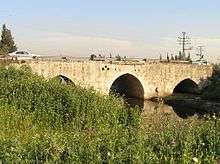
Jisr Jindas, Arabic for "Jindas Bridge",[1] also known as Baybars Bridge, was built in 1273 C.E. It crosses a small wadi, known in Hebrew as the Ayalon River, on the old road leading south to Lod and Ramla.[2] The bridge is named after the village of Jindas, which once stood east of the bridge and may have been the Crusader-period "casal of Gendas" mentioned in a Latin charter dated 1129 CE.[3] It is the most famous of the several bridges erected by Sultan Baybars in Palestine, which include the Yibna and the Isdud bridges.[4]
History

The present structure dates to AH 672/AD 1273, but is believed to be constructed on Roman foundations.[5] It was first studied in modern times by Charles Simon Clermont-Ganneau, who noted that an Arabic chronicle had referred to the construction by Baybars in AH 672 of two bridges of a significant nature "in the neighbourhood of Ramleh".[6] The second of these two bridges is thought to be the Yibna Bridge.[6]
Clermont-Ganneau concluded that the bridge was built using masonry reclaimed from the Church of Saint George, which had been destroyed in the Crusader-Ayyubid War.[6]
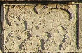
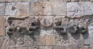
On the west and east faces of the bridge are two nearly identical inscriptions, flanked by two lions (or leopards). The inscription on the east reads as follows:
"Bismallah..., and blessings on their lord Muhammad, his family and his companions. The building of this blessed bridge was ordered by their master, the great Sultan al-Malik al-Zahir Rukn al-Din Baybars, ibn Abd Allah, in time of his son their Lord Sultan al-Malik al-Said Nasir al-Din Baraka Khan, may Allah glorify their victories and grant them His grace. And that, under the direction of the humble servant aspiring to the mercy of Allah. Ala al-Din Ali al-Suwwaq, may Allah grant grace to him and his parents, in the month of Ramadan, the year 671 H. [March–April 1273 C.E.]
Ala al-Din Ali al-Suwwaq was the same official charged with overseeing the construction of the Great Mosque of Lydda three years earlier.[7]
In 1882 the Palestine Exploration Fund's Survey of Western Palestine noted that Jisr Jindas had a representation of two lions and an Arabic text. It further noted that it appeared to be "Saracenic work".[8]
Description
The bridge is over 30 metres (98 ft) long and 10 metres (33 ft) wide, and runs north-south. It consists of three arches and two central piers, with the central arch wider than the two other arches.[2]
Baybars panthers or lions
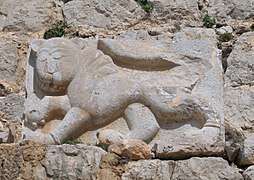
In his native Turkic language, Baibars' name means "great panther".[9] Possibly based on that, Baibars used the panther as his heraldic blazon, and placed it on both coins and buildings.[9] On the Bridge of Jindas, the lions/panthers used play with a rat, which may be interpreted to represent Baibars' Crusader enemies.[10]
According to Moshe Sharon, the lions on Jisr Jindas are similar to the ones on the Lions' Gate in Jerusalem, and Qasr al-Basha in Gaza. All represent the same sultan: Baybars. The Gaza lions were created with interlocking lines suggesting leopard spots, however, the felines' outline is similar. Sharon estimates that they all date to approximately 1273 C.E.[11]
See also
References
- ↑ "The bridge of Jindas", according to Palmer, 1881, p. 215
- 1 2 Petersen, 2001, p.183
- ↑ Clermont-Ganneau, 1896, vol.2, p. 117, who quotes the Cartulaire général de l'ordre des Hospitaliers, no.84
- ↑ Petersen, 2008, p.297
- ↑ O’Connor, 1993
- 1 2 3 Clermont-Ganneau, 1896, vol.2, pp.110–117
- ↑ Petersen, 2001, p. 184
- ↑ Conder and Kitchener, 1882, SWP II, pp. 264–5
- 1 2 Heghnar Zeitlian Watenpaugh (2004). The image of an Ottoman city: imperial architecture and urban experience in Aleppo in the 16th and 17th centuries. Brill. p. 198. ISBN 90-04-12454-3.
- ↑ Niall Christie (2014). Muslims and Crusaders: Christianity’s Wars in the Middle East, 1095-1382, from the Islamic Sources. Seminar Studies (first ed.). Routledge. p. 121, Plate 8. ISBN 9781138022744.
- ↑ Sharon, 2009, p. 58 and pl.6.
Bibliography
- Clermont-Ganneau, C.S., "Le pont de Beibars à Lydda." In Recueil d'archéologie orientale. Clermont-Ganneau, Charles. 262–279. Paris: Ernest Leroux, 1888. (editio princeps)
- Clermont-Ganneau, C.S. (1896). [ARP] Archaeological Researches in Palestine 1873–1874, translated from the French by J. McFarlane. 2. London: Palestine Exploration Fund.
- Conder, C.R.; Kitchener, H.H. (1882). The Survey of Western Palestine: Memoirs of the Topography, Orography, Hydrography, and Archaeology. 2. London: Committee of the Palestine Exploration Fund.
- O’Connor, Colin (1993), Roman Bridges, Cambridge University Press, ISBN 0-521-39326-4
- Palmer, E.H. (1881). The Survey of Western Palestine: Arabic and English Name Lists Collected During the Survey by Lieutenants Conder and Kitchener, R. E. Transliterated and Explained by E.H. Palmer. Committee of the Palestine Exploration Fund.
- Petersen, Andrew (2001). A Gazetteer of Buildings in Muslim Palestine (British Academy Monographs in Archaeology). 1. Oxford University Press. ISBN 978-0-19-727011-0. pp. 183–186
- Petersen, A. (2008): Bridges in Medieval Palestine, in U. Vermeulen & K. Dhulster (eds.), History of Egypt & Syria in the Fatimid, Ayyubid & Mamluk Eras V, V. Peeters, Leuven
- Sharon, M. (1999). Corpus Inscriptionum Arabicarum Palaestinae, B-C. 2. BRILL. ISBN 90-04-11083-6. p.229: "From Ramlah the route continued to Ludd (Lydda) and over a bridge (near Jindas) to the north of the city built in 1273, up to the khan of Jaljulyah, built around 1325."
- Sharon, M. (2009). Corpus Inscriptionum Arabicarum Palaestinae, G. 4. BRILL. ISBN 90-04-17085-5.
External links
- Survey of Western Palestine, Map 13: IAA, Wikimedia commons
Coordinates: 31°58′07.51″N 34°54′00.78″E / 31.9687528°N 34.9002167°E