Jericho, Vermont
| Jericho, Vermont | |
|---|---|
| Town | |
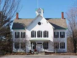 T Town hall of Jericho, Vermont | |
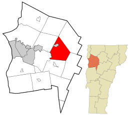 Location in Chittenden County and the state of Vermont. | |
 Jericho, Vermont Location in the United States | |
| Coordinates: 44°28′53″N 72°57′54″W / 44.48139°N 72.96500°W | |
| Country | United States |
| State | Vermont |
| County | Chittenden |
| Communities |
Jericho Jericho Center Nashville Riverside Underhill Flats (part) |
| Area | |
| • Total | 35.6 sq mi (92.1 km2) |
| • Land | 35.4 sq mi (91.7 km2) |
| • Water | 0.2 sq mi (0.4 km2) |
| Elevation | 121 ft (37 m) |
| Population (2010) | |
| • Total | 5,009 |
| • Density | 141/sq mi (54.6/km2) |
| Time zone | UTC−5 (Eastern (EST)) |
| • Summer (DST) | UTC−4 (EDT) |
| ZIP code | 05465 |
| Area code(s) | 802 |
| FIPS code | 50-36700[1] |
| GNIS feature ID | 1462128[2] |
| Website |
www |
Jericho is a town in Chittenden County, Vermont, United States. The population was 5,009 at the 2010 census.[3] It was named after the ancient city of Jericho.[4]
Geography

According to the United States Census Bureau, the town has a total area of 35.6 square miles (92.1 km2), of which 35.4 square miles (91.7 km2) is land and 0.15 square miles (0.4 km2), or 0.45%, is water.[3]
Two towns
The town of Jericho has a connection with the neighboring town of Underhill. The area has four distinct village areas. The historic Old Red Mill, home of the Jericho Historical Society,[5] stands in Jericho village (also known as Jericho Corners) on Route 15 in the northwest part of the town, an area that extends from the Browns River crossing near Joe's Snack Bar eastward to the post office and the Jericho Elementary School. Jericho Corners is the location of the Galusha House, home of Truman Galusha, a brick Federal-style house built in 1790 and like Jericho's Old Red Mill, listed on the National Register of Historic Places.[6]
Jericho's second village, Jericho Center, on Browns Trace Road, is home to several historic buildings, churches, and Jericho Center Country Store, Vermont's oldest continuously running general store. The Jericho Center Village has a village green, or "Common", a typical park-like center of a Vermont village, surrounded by historic buildings.
Next, half of the Underhill Flats area on Route 15 actually sits in Jericho. This area features the multi-use Mills Riverside Park and two general stores (Jolly & Jacob's).
Underhill Center in the town of Underhill has two general stores, as well as St. Thomas Catholic Church, a small postal office, and access to Underhill State Park.
Jericho is home to the Chittenden East Wolverines of the Northern Vermont Youth Football League, Cub Scout Pack 620 and one of Vermont's oldest and largest Boy Scout troops, Troop 627.
The two towns share the Underhill-Jericho Fire Department.[7]
Schools
Local schools include Jericho Elementary School and Underhill ID Elementary School, serving from kindergarten through fourth grade. Browns River Middle School teaches grades five through eight. There is one high school in Jericho—Mount Mansfield Union High School—which serves students from Jericho, Underhill, Richmond, Huntington, Bolton, Jonesville, and Westford.
Students from Mount Mansfield Union High School are allowed to apply to a vocational school for their junior and senior years. They can apply to either The Center for Technology, Essex (CTE), or the Burlington Technical Center (BTC). CTE is located in Essex Junction and is part of the larger Essex High School (EHS).
MMU has 814 students enrolled as of 2018, making it the eighth most enrolled school in Vermont.[8]
On November 4, 2014, the communities of Bolton, Jericho, Richmond, Underhill ID and Underhill Town voted to form the Mount Mansfield Modified Union School District also known as the MMMUSD.[9] This new school district is intended to serve and govern the current town school districts of Bolton (Smilie Memorial School), Jericho (Jericho Elementary), Richmond (Richmond Elementary), Underhill ID School District (Underhill ID Elementary), Underhill Town (Underhill Central School), Mt Mansfield Union School District (Browns River Middle, Camels Hump Middle and Mt. Mansfield Union High Schools) in grades Pre-K through 12 and Huntington students grades 5-12.[10]
Demographics
| Historical population | |||
|---|---|---|---|
| Census | Pop. | %± | |
| 1790 | 381 | — | |
| 1800 | 728 | 91.1% | |
| 1810 | 1,185 | 62.8% | |
| 1820 | 1,219 | 2.9% | |
| 1830 | 1,654 | 35.7% | |
| 1840 | 1,684 | 1.8% | |
| 1850 | 1,837 | 9.1% | |
| 1860 | 1,669 | −9.1% | |
| 1870 | 1,757 | 5.3% | |
| 1880 | 1,687 | −4.0% | |
| 1890 | 1,461 | −13.4% | |
| 1900 | 1,373 | −6.0% | |
| 1910 | 1,307 | −4.8% | |
| 1920 | 1,138 | −12.9% | |
| 1930 | 1,091 | −4.1% | |
| 1940 | 1,077 | −1.3% | |
| 1950 | 1,135 | 5.4% | |
| 1960 | 1,425 | 25.6% | |
| 1970 | 2,343 | 64.4% | |
| 1980 | 3,575 | 52.6% | |
| 1990 | 4,302 | 20.3% | |
| 2000 | 5,015 | 16.6% | |
| 2010 | 5,009 | −0.1% | |
| Est. 2014 | 5,074 | [11] | 1.3% |
| U.S. Decennial Census[12] | |||
As of the census[1] of 2000, there were 5,015 people, 1,751 households, and 1,402 families residing in the town. The population density was 141.7 people per square mile (54.7/km2). There were 1,774 housing units at an average density of 50.1 per square mile (19.4/km2). The racial makeup of the town was 97.45% White, 0.68% Black or African American, 0.14% Native American, 0.56% Asian, 0.08% Pacific Islander, 0.30% from other races, and 0.80% from two or more races. Hispanic or Latino of any race were 1.12% of the population.
There were 1,751 households out of which 45.9% had children under the age of 18 living with them, 70.4% were married couples living together, 7.1% had a female householder with no husband present, and 19.9% were non-families. 14.3% of all households were made up of individuals and 4.3% had someone living alone who was 65 years of age or older. The average household size was 2.86 and the average family size was 3.19.
In the town, the population was spread out with 30.9% under the age of 18, 4.6% from 18 to 24, 31.7% from 25 to 44, 26.4% from 45 to 64, and 6.4% who were 65 years of age or older. The median age was 37 years. For every 100 females, there were 98.1 males. For every 100 females age 18 and over, there were 92.6 males.
The median income for a household in the town was $65,375, and the median income for a family was $72,500. Males had a median income of $49,375 versus $30,488 for females. The per capita income for the town was $24,941. About 3.6% of families and 4.6% of the population were below the poverty line, including 6.2% of those under age 18 and 3.7% of those age 65 or over.
Notable people
- Wilson "Snowflake" Bentley (1865–1931), a farmer who photographed over five thousand snow crystals, was born and lived in Jericho.[13] Bentley's photographic works are presented at The Old Red Mill & Museum in the center of town.[5]
- Anson Rood, Wisconsin State Assemblyman and businessman born in Jericho
References
- 1 2 "American FactFinder". United States Census Bureau. Retrieved 2008-01-31.
- ↑ "US Board on Geographic Names". United States Geological Survey. 2007-10-25. Retrieved 2008-01-31.
- 1 2 "Geographic Identifiers: 2010 Census Summary File 1 (G001): Jericho town, Chittenden County, Vermont". U.S. Census Bureau, American Factfinder. Retrieved August 19, 2015.
- ↑ Gannett, Henry (1905). The Origin of Certain Place Names in the United States. Govt. Print. Off. p. 169.
- 1 2 "Jericho Historical Society". Jericho Historical Society.
- ↑ "National Register of Historical Places - VERMONT (VT), Chittenden County". National Register of Historic Places. Retrieved October 27, 2014.
- ↑ "Home | Underhill Jericho Fire Department". Home | Underhill Jericho Fire Department.
- ↑ "2018 Largest Public High Schools in Vermont". Niche. Retrieved 2018-03-30.
- ↑ Niles, Hilary (2014-11-05). "Chittenden East approves voluntary school merger". VTDigger. Retrieved 2018-03-30.
- ↑ "Chittenden East Supervisory Union". www.cesu.k12.vt.us.
- ↑ "Annual Estimates of the Resident Population for Incorporated Places: April 1, 2010 to July 1, 2014". Archived from the original on May 23, 2015. Retrieved June 4, 2015.
- ↑ "U.S. Decennial Census". United States Census Bureau. Archived from the original on May 12, 2015. Retrieved May 16, 2015.
- ↑ Hughes, Victoria. "Wilson "Snowflake" Bentley - Vermont Historical Society". vermonthistory.org. Retrieved 2018-03-30.
External links

- Town of Jericho official website
- Camels Hump Middle School
- Browns River Middle School
- Mount Mansfield Union High School
- Center for Technology, Essex School
Coordinates: 44°28′53″N 72°57′54″W / 44.48139°N 72.96500°W
Municipalities and communities of Chittenden County, Vermont, United States | ||
|---|---|---|
| Cities | 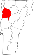 | |
| Towns | ||
| Villages | ||
| CDPs | ||
| Unincorporated communities | ||
| Authority control |
|---|