Jasper, Arkansas
| Jasper, Arkansas | |
|---|---|
| City | |
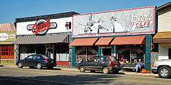 Historic downtown Jasper | |
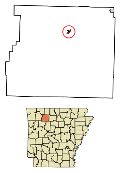 Location of Jasper in Newton County, Arkansas. | |
| Coordinates: 36°0′31″N 93°11′8″W / 36.00861°N 93.18556°WCoordinates: 36°0′31″N 93°11′8″W / 36.00861°N 93.18556°W | |
| Country | United States |
| State | Arkansas |
| County | Newton |
| Area[1] | |
| • Total | 0.58 sq mi (1.49 km2) |
| • Land | 0.56 sq mi (1.44 km2) |
| • Water | 0.02 sq mi (0.05 km2) |
| Elevation | 846 ft (258 m) |
| Population (2010) | |
| • Total | 466 |
| • Estimate (2017)[2] | 440 |
| • Density | 788.53/sq mi (304.57/km2) |
| Time zone | UTC-6 (Central (CST)) |
| • Summer (DST) | UTC-5 (CDT) |
| ZIP code | 72641 |
| Area code(s) | 870 |
| FIPS code | 05-34900 |
| GNIS feature ID | 0072172 |
Jasper is a city in Newton County, Arkansas, United States. According to the 2010 census, its population is 466. The city is the county seat of Newton County.[3]
Jasper is part of the Harrison Micropolitan Statistical Area.
Geography
Jasper is located at 36°0′31″N 93°11′8″W / 36.00861°N 93.18556°W (36.008558, -93.185660).[4]
According to the United States Census Bureau, the city has a total area of 0.5 square miles (1.3 km2), all land.
Major highway
Demographics
| Historical population | |||
|---|---|---|---|
| Census | Pop. | %± | |
| 1880 | 91 | — | |
| 1910 | 242 | — | |
| 1920 | 253 | 4.5% | |
| 1930 | 385 | 52.2% | |
| 1940 | 412 | 7.0% | |
| 1950 | 407 | −1.2% | |
| 1960 | 273 | −32.9% | |
| 1970 | 394 | 44.3% | |
| 1980 | 519 | 31.7% | |
| 1990 | 332 | −36.0% | |
| 2000 | 498 | 50.0% | |
| 2010 | 466 | −6.4% | |
| Est. 2017 | 440 | [2] | −5.6% |
| U.S. Decennial Census[5] | |||
As of the census[6] of 2000, there were 498 people, 231 households, and 115 families residing in the city. The population density was 940.4 people per square mile (362.8/km²). There were 261 housing units at an average density of 492.9/sq mi (190.1/km²). The racial makeup of the city was 99.98% White, 0.01% Native American, 0.01% from other races, and 0.00% from two or more races. 0.00% of the population were Hispanic or Latino of any race.
There were 233 households out of which 24.8% had children under the age of 18 living with them, 32.5% were married couples living together, 15.2% had a female householder with no husband present, and 49.8% were non-families. 48.5% of all households were made up of individuals and 27.8% had someone living alone who was 65 years of age or older. The average household size was 1.95 and the average family size was 2.82.
In the city, the population was spread out with 21.3% under the age of 18, 6.4% from 18 to 24, 18.7% from 25 to 44, 22.5% from 45 to 64, and 31.1% who were 65 years of age or older. The median age was 49 years. For every 100 females, there were 71.7 males. For every 100 females age 18 and over, there were 63.7 males.
The median income for a household in the city was $13,556, and the median income for a family was $26,668. Males had a median income of $21,458 versus $16,786 for females. The per capita income for the city was $13,557. About 25.9% of families and 31.6% of the population were below the poverty line, including 47.6% of those under age 18 and 25.4% of those age 65 or over.
Education
Jasper is headquarters for the Jasper School District, which is geographically one of the state's largest and serves portions of five counties.[7] Jasper School District includes the Jasper Elementary School and Jasper High School.
References
- ↑ "2017 U.S. Gazetteer Files". United States Census Bureau. Retrieved Aug 22, 2018.
- 1 2 "Population and Housing Unit Estimates". Retrieved March 24, 2018.
- ↑ "Find a County". National Association of Counties. Archived from the original on 2011-05-31. Retrieved 2011-06-07.
- ↑ "US Gazetteer files: 2010, 2000, and 1990". United States Census Bureau. 2011-02-12. Retrieved 2011-04-23.
- ↑ "Census of Population and Housing". Census.gov. Archived from the original on May 12, 2015. Retrieved June 4, 2015.
- ↑ "American FactFinder". United States Census Bureau. Retrieved 2008-01-31.
- ↑ School District Reference Map (2010 Census): Newton County, AR (PDF) (Map). US Census Bureau. Retrieved 2011-06-28.
| Wikimedia Commons has media related to Jasper, Arkansas. |
External links
- Map of Jasper (US Census Bureau)
- Jasper School District
- Newton County Times
- Newton County Historical Society
- Jasper/Newton County Chamber of Commerce
- Jasper entry in the Encyclopedia of Arkansas
Municipalities and communities of Newton County, Arkansas, United States | ||
|---|---|---|
| City | 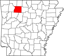 | |
| Town | ||
| Townships |
| |
| Unincorporated communities | ||