West Jaintia Hills district
| West Jaintia Hills district Jaintia | |
|---|---|
| District of Meghalaya | |
| Country | India |
| State | Meghalaya |
| Headquarters | Jowai |
| Government | |
| • Assembly seats | 4 |
| Area | |
| • Total | 1,693 km2 (654 sq mi) |
| Population (2011) | |
| • Total | 270,352 |
| • Density | 160/km2 (410/sq mi) |
| Demographics | |
| • Literacy | 63.5% |
| Major highways | NH-44, NH-40 |
| Website | Official website |
West Jaintia Hills (Pron: ˈʤeɪnˌtɪə) is an administrative District in the state of Meghalaya in India. The united district (Jaintia Hills District) was created on 22 February 1972 and occupied an area of 3819 km2. It had a population of 295,692 (as of 2001). The district is part of the Meghalaya subtropical forests ecoregion.With the bifurcation of the erstwhile Jaintia Hills District into East and West Jaintia Hills Districts, West Jaintia Hills District came into existence on 31 July 2012 with its headquarters at Jowai. Jowai is the host of all the heads of important governmental offices and establishments, educational institutions, hospitals, banking institutions, etc.[1]
Geography
The total area of the district is 1693 km2. The district comprises one Civil Sub-Division Viz. Amlarem Civil Sub-Division and three Community and Rural Development Blocks viz. Amlarem C&RD Block, Laskein C&RD Block and Thadlaskein C&RD Block with the following boundaries:
- North – Assam
- South – Bangladesh and East Jaintia Hills district
- East – Assam
- West – East Khasi Hills District[2]
Economy
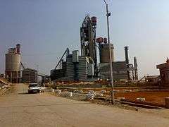
Although the mainstay of the district is agriculture, however, due to the abundance of Limestone, plenty of Cement factories have been set up in the district (now East Jaintia Hills). More are set to come up. Coal mining at sites like Lad Rymbai(East Jaintia Hills district) is also one of the major activities set up here.Coal mined here is mostly exported to Bangladesh and Assam. Most of the coal mining sites are now situated in the East Jaintia Hills district.
Divisions
Administrative divisions
United Jaintia Hills district was divided into five blocks. With the bifurcation of the erstwhile district, West Jaintia Hills is divided into three blocks:[3]
| Name | Headquarters | Population | Location |
| Amlarem | Amlarem |  | |
| Laskein | Laskein |  | |
| Thadlaskein | Thadlaskein |  |
East Jaintia Hills district is divided into two blocks, namely:
| Name | Headquarters | Population | Location |
| Khliehriat | Khliehriat |  | |
| Saipung | Saipung | 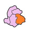 |
Transport
Since it is land locked region and lack of railways and airport, the only means of transportation is roadways. The main highway which runs through the district is NH 40 and NH 44.
Demographics
The district has a total population of 270,352, of which 134,406 are males and 135,946 are females. The density of population is 159.69 per km2.
Languages
The common dialect in West Jaintia hills is Pnar, belonging to the Jaintia language. Other dialects include War-Jaintia speaking to the southern part of the district and Biate, spoken by approximately 20,000 members.The Biates also resides in the Saipung elaka in East Jaintia Hills district.
Culture
Places of interest
The places of interest in Jaintia hills include the below:
- Monolith in Nartiang[4] - Touted as the tallest monolith in the world.
- Jowai: Jowai, the headquarters of the West Jaintia Hills district is situated 64 km from the national highway. A town circled by the Myntdu River.
- Thadlaskein Lake: 56 km from Shillong. According to legend this lake was dug with the ends of bows by members of 290 clans of USajiar Niangli, a rebel general of Jaintia Raja, to commemorate the great exodus of the clans.
- Megalithic Remnants- Nartiang: 65 km from Shillong, was the summer capital of the Jaintia Kings, of Sutnga State. Huge monoliths, form a landmark in the village. The Nartiang menhir measures 27 feet 6 inches in thickness.
- Syndai: An important village of West Jaintia Hills which is famous for a number of caves and caverns in the limestone-borne area, used as hide-outs during war times between Jaintia Hills and foreign intruders.
- Syntu Ksiar: Syntu Ksiar, which means 'golden flower' is a vast pool of calm water, where the river Myntdu which almost encircles Jowai, appears to come to a sudden halt.
- Krangsuri Falls* A tourist spot in Amlarem Sub-Division (War-Jaintia)
Education
Although West Jaintia Hills is not known as an education hub. Good schools and colleges do exist in Jowai, Khliehriat and Nongtalang. Prominent Colleges in West Jaintia hills include Jowai Polytechnic A reputed and the only Nursing School in the district namely Dr. Norman Tunnel Hospital School Of Nursing, Thomas Jones College, Nongtalang College and Kiang Nangbah Govt. College Jowai which offers degree courses in arts and science. Jowai has good schools too for Secondary and Higher Secondary level.
See also
References
- ↑
- ↑
- ↑ Meghalaya Administrative Divisions (PDF) (Map). The Registrar General & Census Commissioner, India, New Delhi, Ministry of Home Affairs, Government of India. 2011. Retrieved 2011-09-29.
- ↑ "Tallest Monolith". Merinews.com. 2009-02-17. Retrieved 18 October 2017.
Places adjacent to West Jaintia Hills district | ||||||||||
|---|---|---|---|---|---|---|---|---|---|---|
| ||||||||||
| Topics | |
|---|---|
| Administration | |
| Districts | |
| Municipalities | |
| |