Ri-Bhoi district
| Ri Bhoi District district RiBhoi | |
|---|---|
| District of Meghalaya | |
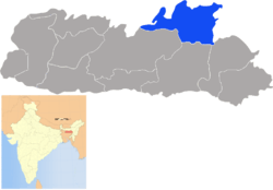 Location of Ri Bhoi District district in Meghalaya | |
| Country | India |
| State | Meghalaya |
| Headquarters | Nongpoh |
| Government | |
| • Assembly seats | 7 |
| Area | |
| • Total | 2,378 km2 (918 sq mi) |
| Population (2001) | |
| • Total | 192,795 |
| • Density | 81/km2 (210/sq mi) |
| Demographics | |
| • Literacy | 51% |
| Major highways | NH-40 |
| Website | Official website |
Ri Bhoi (IPA: ˌrɪ ˈbɔɪ) is an administrative district in the state of Meghalaya in India. The district headquarters are located at Nongpoh. The district occupies an area of 2378 km² and has a population of 192,795 (as of 2001). As of 2011 it is the second least populous district of Meghalaya (out of 7), after South Garo Hills.[1]
History
The district was upgraded from subdivisional level to a full-fledged district on 4 June 1992. The new District, was carved out from East Khasi Hills.
Geography
The District lies between 90°55’15 to 91°16’ latitude and 25°40’ to 25°21’ longitude. It is bounded on the north by Kamrup District and on the East by Jaintia Hills and Karbi Anglong District of Assam and on the West by West Khasi Hills District. There are three C and RD Blocks and one administrative unit at Patharkhmah, and the number of villages is 561. Ri Bhoi District covers an area of 2448 km².
The headquarters of the District is at Nongpoh located at 53 km away from the state capital Shillong and 50 km from Guwahati. This District is characterized by rugged and irregular land surface. It includes a series of hill ranges which gradually sloped towards the north and finally joins the Brahmaputra Valley. The important rivers flowing through this region includes the Umtrew, Umsiang, Umran and Umiam rivers.
Flora and fauna
In 1981 Ri-Bhoi district became home to the Nongkhyllem Wildlife Sanctuary, which has an area of 29 km2 (11.2 sq mi).[2]
Economy
In 2006 the Ministry of Panchayati Raj named Ri-Bhoi one of the country's 250 most backward districts (out of a total of 640).[3] It is one of the three districts in Meghalaya currently receiving funds from the Backward Regions Grant Fund Programme (BRGF).[3]
Administration
Administrative divisions
Ri-Bhoi district is divided into three blocks:[4]
| Name | Headquarters | Population | Location |
| Jirang | Wahsynon |  | |
| Umling | Nongpoh |  | |
| Umsning | Umsning | 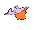 |
Transport
The region is still poor in transport and communication facilities. The National Highway No.37 origination from Jorabat to Shillong passes through the District.
Demographics
Population
Khasi people form the majority of Ri Bhoi District population about 85%, while rest are Nepalis 9%, 4% Biharis, 1% Muslim's and 1% other tribes. According to the 2011 census Ri-Bhoi district has a population of 258,380,[1] roughly equal to the nation of Vanuatu.[5] This gives it a ranking of 580th in India (out of a total of 640).[1] The district has a population density of 109 inhabitants per square kilometre (280/sq mi) .[1] Its population growth rate over the decade 2001-2011 was 34.02%.[1] Ri Bhoi has a sex ratio of 951 females for every 1000 males,[1] and a literacy rate of 77.22%.[1]
Languages
The main Language spoken in Ribhoi is Karew which is its native spoken language. It is more popularly known to other people as the Bhoi language. Languages used in the district include Amri, a Tibeto-Burman language related with Karbi, with 125 000 speakers and Tiwa (Lalung) language with 11,438 speakers related to Indigenous Assamese ethnic Tiwa community people.[6]
References
- 1 2 3 4 5 6 7 "District Census 2011". Census2011.co.in. 2011. Retrieved 2011-09-30.
- ↑ Indian Ministry of Forests and Environment. "Protected areas: Meghalaya". Archived from the original on August 23, 2011. Retrieved September 25, 2011.
- 1 2 Ministry of Panchayati Raj (September 8, 2009). "A Note on the Backward Regions Grant Fund Programme" (PDF). National Institute of Rural Development. Archived from the original (PDF) on April 5, 2012. Retrieved September 27, 2011.
- ↑ Meghalaya Administrative Divisions (PDF) (Map). The Registrar General & Census Commissioner, India, New Delhi, Ministry of Home Affairs, Government of India. 2011. Retrieved 2011-09-29.
- ↑ US Directorate of Intelligence. "Country Comparison:Population". Retrieved 2011-10-01.
Vanuatu 224,564 July 2011 est.
- ↑ M. Paul Lewis, ed. (2009). "Amri Karbi: A language of India". Ethnologue: Languages of the World (16th ed.). Dallas, Texas: SIL International. Retrieved 2011-09-28.
External links
Places adjacent to Ri-Bhoi district | |
|---|---|
| Topics | |
|---|---|
| Administration | |
| Districts | |
| Municipalities | |
| |