South West Khasi Hills district
| South West Khasi Hills district South West Khasi | |
|---|---|
| District of Meghalaya | |
 Location of South West Khasi Hills district in Meghalaya | |
| Country | India |
| State | Meghalaya |
| Headquarters | Mawkyrwat |
| Area | |
| • Total | 1,341 km2 (518 sq mi) |
| Population (2011) | |
| • Total | 110,152 |
| • Density | 82/km2 (210/sq mi) |
| Demographics | |
| • Literacy | 76.84 |
| Website | Official website |
South West Khasi Hills is an administrative district in the state of Meghalaya in India.
History
The South West Khasi Hills district was carved out of the West Khasi Hills district on 3 August 2012.[1]
Geography
The district headquarters is located at Mawkyrwat. The district occupies an area of 1,341 km². The district is compose all the villages of two Community & Rural Development Blocks viz. Ranikor and Mawkyrwat are Community & Rural Development Block, including 18 (Eighteen) Villages under Warsan Lyngdoh Gram Sevak Circle of Nongstoin in Community & Rural Development Block.
Administrative divisions
South West Khasi Hills district is divided into two blocks
| Name | Headquarters | Population | Location |
| Mawkyrwat | Mawkyrwat | 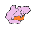 | |
| Ranikor | Ranikor | 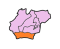 |
References
- ↑ Official circular regarding Mawkyrwat Archived 2013-11-05 at the Wayback Machine.
External links
Places adjacent to South West Khasi Hills district | ||||||||||
|---|---|---|---|---|---|---|---|---|---|---|
| ||||||||||
| Topics | |
|---|---|
| Administration | |
| Districts | |
| Municipalities | |
| |
This article is issued from
Wikipedia.
The text is licensed under Creative Commons - Attribution - Sharealike.
Additional terms may apply for the media files.