Jacobs River, New Zealand
| Jacobs River | |
|---|---|
| Settlement | |
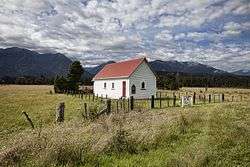 Our Lady of the River church, Jacobs River, in 2011. The church was destroyed by Cyclone Fehi in 2018. | |
 Jacobs River | |
| Coordinates: 43°34′18″S 169°40′47″E / 43.57167°S 169.67972°ECoordinates: 43°34′18″S 169°40′47″E / 43.57167°S 169.67972°E | |
| Country | New Zealand |
| Region | West Coast |
| District | Westland District |
| Electorates |
West Coast-Tasman Te Tai Tonga |
| Time zone | UTC+12 (NZST) |
| • Summer (DST) | UTC+13 (NZDT) |
| Postcode | 7886 |
| Area code(s) | 03 |
| Local iwi | Ngāi Tahu |
Jacobs River is a locality in the West Coast region of the South Island of New Zealand, situated just to the north of where State Highway 6 crosses the Jacobs River. Bruce Bay is about 7 kilometres (4 mi) to the south-west, and Fox Glacier is almost 40 kilometres (25 mi) to the north-east, by road.[1][2]
Church
A small Anglican church, known as St Peter's church, was built at Jacobs River in 1931. It was later taken over by the Roman Catholic church when the Anglican congregation in the area declined, and renamed Our Lady of the River. During Cyclone Fehi in early 2018, the church was blown off its foundations and destroyed.[3]
Education
The nearest school is in Fox Glacier, following the closure of Jacobs River School on 27 January 2013.[4]
References
- ↑ Peter Dowling (editor) (2004). Reed New Zealand Atlas. Reed Books. pp. map 76. ISBN 0-7900-0952-8.
- ↑ Roger Smith, GeographX (2005). The Geographic Atlas of New Zealand. Robbie Burton. pp. map 172. ISBN 1-877333-20-4.
- ↑ Sherman, Janna (5 February 2018). "Loss of church a 'devastating blow'". Otago Daily Times. Retrieved 17 March 2018.
- ↑ Mussen, Deidre (20 December 2012). "Class dismissed for last time at tiny school". The Press. Retrieved 14 March 2014.
External links
This article is issued from
Wikipedia.
The text is licensed under Creative Commons - Attribution - Sharealike.
Additional terms may apply for the media files.