Jänschwalde
| Jänschwalde/Janšojce | |
|---|---|
 Jänschwalde/Janšojce Location of Jänschwalde/Janšojce within Spree-Neiße district 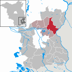 | |
| Coordinates: 51°51′43″N 14°29′57″E / 51.86194°N 14.49917°ECoordinates: 51°51′43″N 14°29′57″E / 51.86194°N 14.49917°E | |
| Country | Germany |
| State | Brandenburg |
| District | Spree-Neiße |
| Municipal assoc. | Peitz |
| Government | |
| • Mayor | Heinz Schwietzer (Ind.) |
| Area | |
| • Total | 81.24 km2 (31.37 sq mi) |
| Elevation | 62 m (203 ft) |
| Population (2017-12-31)[1] | |
| • Total | 1,537 |
| • Density | 19/km2 (49/sq mi) |
| Time zone | CET/CEST (UTC+1/+2) |
| Postal codes | 03197, außer OT Grießen: 03172 |
| Dialling codes | 035607, außer OT Grießen: 035696 |
| Vehicle registration | SPN |
Jänschwalde (Sorbian: Janšojce) is a municipality in the district of Spree-Neiße in Brandenburg in East Germany. It is situated in the region of Niederlausitz. The nearest town is Peitz; Cottbus is 25 km away.
Municipal arrangement
The municipality of Jänschwalde-Janšojce is divided into three parts:
- Jänschwalde-Dorf
- Kolonie
- Jänschwalde East
Jänschwalde-Dorf
Jänschwalde-Dorf (village) is separated from Kolonie by a small brook called Puschanitzka. It flows through a field between the two districts. In the village there is a tavern called K5. Not far away from there is a small store and a place called the Jugendbude, for the young people of the village.
Near the store and the Jugendbude is the village church, which was built in 1806/07. In the nearby belltower there are three bells from the 15th and 16th centuries. Also next to the church is the German-Sorb Museum, which details the area's past.
Kolonie
In Kolonie (colony) the inhabitants have a butcher, a store, a post office, and a restaurant—the brewery Zur Linde. The cemetery is also located in Kolonie.
Jänschwalde East
Three kilometers into the forest is East Jänschwalde, which was established in 1952 as a housing development for the soldiers of the nearby air base. Here there are mostly new buildings, including a primary school and a kindergarten. There is also das Ländliche Sozio-kulturelle Zentrum (the Rural Socio-Cultural Center), which serves as a meeting place for young and old. Activities there include crafting afternoons, a library, and sport programs, such as judo. East Jänschwalde is also connected to the public railroad network through the Regional Express line from Cottbus to Frankfurt (Oder).
Demography
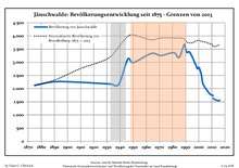
| Jänschwalde: Population development within the current boundaries (2013)[2] | |||||||||||||||||||||||||||||||||||||||||||||||||||||||||||||||||||||||||||||||||||||||||||||||||||||||||||||||||||||||||||||||
|---|---|---|---|---|---|---|---|---|---|---|---|---|---|---|---|---|---|---|---|---|---|---|---|---|---|---|---|---|---|---|---|---|---|---|---|---|---|---|---|---|---|---|---|---|---|---|---|---|---|---|---|---|---|---|---|---|---|---|---|---|---|---|---|---|---|---|---|---|---|---|---|---|---|---|---|---|---|---|---|---|---|---|---|---|---|---|---|---|---|---|---|---|---|---|---|---|---|---|---|---|---|---|---|---|---|---|---|---|---|---|---|---|---|---|---|---|---|---|---|---|---|---|---|---|---|---|---|
|
| ||||||||||||||||||||||||||||||||||||||||||||||||||||||||||||||||||||||||||||||||||||||||||||||||||||||||||||||||||||||||||||||
Points of interest
References
- ↑ "Bevölkerung im Land Brandenburg nach amtsfreien Gemeinden, Ämtern und Gemeinden 31. Dezember 2017 (Fortgeschriebene amtliche Einwohnerzahlen auf Grundlage des Zensus 2011)". Amt für Statistik Berlin-Brandenburg (in German). 2018.
- ↑ Detailed data sources are to be found in the Wikimedia Commons.Population Projection Brandenburg at Wikimedia Commons