Schmogrow-Fehrow
| Schmogrow-Fehrow Smogorjow-Prjawoz | |
|---|---|
 Schmogrow-Fehrow Smogorjow-Prjawoz Location of Schmogrow-Fehrow Smogorjow-Prjawoz within Spree-Neiße district 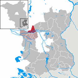 | |
| Coordinates: 51°51′00″N 14°13′00″E / 51.85000°N 14.21667°ECoordinates: 51°51′00″N 14°13′00″E / 51.85000°N 14.21667°E | |
| Country | Germany |
| State | Brandenburg |
| District | Spree-Neiße |
| Municipal assoc. | Burg (Spreewald) |
| Government | |
| • Mayor | Ulrike Ketzmerick (WSF) |
| Area | |
| • Total | 30.11 km2 (11.63 sq mi) |
| Elevation | 55 m (180 ft) |
| Population (2017-12-31)[1] | |
| • Total | 789 |
| • Density | 26/km2 (68/sq mi) |
| Time zone | CET/CEST (UTC+1/+2) |
| Postal codes | 03096 |
| Dialling codes | 035603, 035606 |
| Vehicle registration | SPN |
| Website | www.amt-burg-spreewald.de |
Schmogrow-Fehrow (Lower Sorbian: Smogorjow-Prjawoz) is a municipality in the district of Spree-Neiße, in Brandenburg, Germany.
Demography
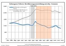
Development of population since 1875 within the current boundaries (Blue line: Population; Dotted line: Comparison to population development of Brandenburg state; Grey background: Time of Nazi rule; Red background: Time of communist rule)
| Schmogrow-Fehrow: Population development within the current boundaries (2013)[2] | |||||||||||||||||||||||||||||||||||||||||||||||||||||||||||||||||||||||||||||||||||||||||||||||||||||||||||||||||||||||||||||||
|---|---|---|---|---|---|---|---|---|---|---|---|---|---|---|---|---|---|---|---|---|---|---|---|---|---|---|---|---|---|---|---|---|---|---|---|---|---|---|---|---|---|---|---|---|---|---|---|---|---|---|---|---|---|---|---|---|---|---|---|---|---|---|---|---|---|---|---|---|---|---|---|---|---|---|---|---|---|---|---|---|---|---|---|---|---|---|---|---|---|---|---|---|---|---|---|---|---|---|---|---|---|---|---|---|---|---|---|---|---|---|---|---|---|---|---|---|---|---|---|---|---|---|---|---|---|---|---|
|
| ||||||||||||||||||||||||||||||||||||||||||||||||||||||||||||||||||||||||||||||||||||||||||||||||||||||||||||||||||||||||||||||
References
- ↑ "Bevölkerung im Land Brandenburg nach amtsfreien Gemeinden, Ämtern und Gemeinden 31. Dezember 2017 (Fortgeschriebene amtliche Einwohnerzahlen auf Grundlage des Zensus 2011)". Amt für Statistik Berlin-Brandenburg (in German). 2018.
- ↑ Detailed data sources are to be found in the Wikimedia Commons.Population Projection Brandenburg at Wikimedia Commons
This article is issued from
Wikipedia.
The text is licensed under Creative Commons - Attribution - Sharealike.
Additional terms may apply for the media files.