Iveagh Upper, Lower Half
| Iveagh Upper, Lower Half Uíbh Eachach Uachtarach, An Leath Íochtair[1](Irish) | |
|---|---|
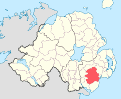 Location of Iveagh Upper, Lower Half, County Down, Northern Ireland. | |
| Sovereign state | United Kingdom |
| Country | Northern Ireland |
| County | Down |
Iveagh Upper, Lower Half is the name of a barony in County Down, Northern Ireland.[2] It was created by 1851 with the division of the barony of Iveagh Upper into two.[3] It lies in the centre of the county, and is bordered by six other baronies: Iveagh Upper, Upper Half and Lordship of Newry to the west; Mourne to the south; Kinelarty and Lecale Upper to the east; and Iveagh Lower, Upper Half to the north.[2]
List of settlements
Below is a list of the villages and population centres in Iveagh Upper, Lower Half:[1][4]
Towns
Villages
Population centres
List of civil parishes
Below is a list of civil parishes in Iveagh Upper, Lower Half:[1][5][4]
- Aghaderg (one townland, rest in baronies of Iveagh Lower, Lower Half and Iveagh Upper, Upper Half)
- Clonduff (also partly in barony of Iveagh Upper, Upper Half (one townland))
- Dromara (also partly in baronies of Iveagh Lower, Lower Half and Kinelarty)
- Drumballyroney
- Drumgooland (also partly in barony of Iveagh Lower, Lower Half (one townland))
- Garvaghy (also partly in barony of Iveagh Lower, Lower Half)
- Kilbroney (one townland, rest in barony of Iveagh Upper, Upper Half)
- Kilcoo (also partly in barony of Iveagh Upper, Upper Half (one townland))
- Kilmegan (also partly in baronies of Kinelarty and Lecale Upper)
- Maghera
- Newry (one townland, rest in baronies of Lordship of Newry, Oneilland West and Orior Upper)
References

This article is issued from
Wikipedia.
The text is licensed under Creative Commons - Attribution - Sharealike.
Additional terms may apply for the media files.