Isidoro Noblía
| Isidoro Noblía | |
|---|---|
| Town | |
 Isidoro Noblía Location in Uruguay | |
| Coordinates: 31°58′0″S 54°7′0″W / 31.96667°S 54.11667°WCoordinates: 31°58′0″S 54°7′0″W / 31.96667°S 54.11667°W | |
| Country |
|
| Department | Cerro Largo Department |
| Population (2011) | |
| • Total | 2,331 |
| Time zone | UTC -3 |
| Postal code | 37002 |
| Dial plan | +598 46 (+6 digits) |
Isidoro Noblía is a small town (villa) in the Cerro Largo Department of eastern Uruguay.
Location
It is located on Route 8, 12 kilometres (7.5 mi) south of Aceguá on the border with Brazil and 45 kilometres (28 mi) north of the city of Melo.
History
Its status was elevated to "Pueblo" (village) on 15 November 1963 by the Act of Ley Nº 13.167[1] and then to "Villa" (town) on 20 October 1992 by the Act of Ley Nº 16.312 [2]
Population
In 2011 Isidoro Noblía had a population of 2,331.[3]
| Year | Population |
|---|---|
| 1963 | 865 |
| 1975 | 1,228 |
| 1985 | 1,548 |
| 1996 | 1,964 |
| 2004 | 2,462 |
| 2011 | 2,331 |
Source: Instituto Nacional de Estadística de Uruguay[4]
References
- ↑ "LEY N° 13.167". República Oriental del Uruguay, Poder Legislativo. 1963. Archived from the original on 16 February 2015. Retrieved 30 June 2011.
- ↑ "LEY N° 16.312". República Oriental del Uruguay, Poder Legislativo. 1992. Archived from the original on 7 January 2013. Retrieved 3 September 2012.
- ↑ "Censos 2011 Cuadros Cerro Largo". INE. 2012. Archived from the original on 10 October 2012. Retrieved 25 August 2012.
- ↑ "Statistics of urban localities (1963–2004)" (PDF). INE. 2012. Retrieved 3 September 2012.
External links
Capital: Melo | ||
| Towns and villages | 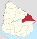 | |
| Sights | ||
This article is issued from
Wikipedia.
The text is licensed under Creative Commons - Attribution - Sharealike.
Additional terms may apply for the media files.