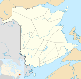
Iron Ore Hill, New Brunswick
| Iron Ore Hill | |
|---|---|
 Iron Ore Hill | |
| Highest point | |
| Elevation | 216 feet (66 m) |
| Coordinates | 46°14′N 67°37′W / 46.233°N 67.617°W |
| Geography | |
| Location | Carleton County, New Brunswick, Canada |
| Parent range | Smyrna Mills Formation |
| Topo map | USGS Mount Shasta |
| Geology | |
| Mountain type | Shield |
| Climbing | |
| First ascent | 1836 |
| Easiest route | Iron Ore Hill Road |
Iron Ore Hill (2001 pop.: ) is a Canadian rural community in Carleton County, New Brunswick, 5 kilometers northwest of Woodstock.
History
The community is located on the slopes of Iron Ore Hill, named from deposits of iron ore and manganese located in the area.[1] The deposit was discovered in 1836.[2][3] Iron was mined near here from 1848 to 1884. A reported 70,000 tons iron ore was smelted during that time.[4] The iron produced was transported to the Woodstock Iron Works to be smelted.[2]
Notable people
See also
References
- ↑ Geological Survey of Canada; R.W. Ells, B.A. (1876). "Report on the ore deposits of Carleton County, New Brunswick". Report of Progress. pp. 97–98.
- 1 2 New Brunswick. General Assembly. Legislative Council (1864). "Report on Mines and Minerals: Woodstock Iron Works". Journal of the Legislative Council of the Province of New Brunswick ... pp. 55–59.
- ↑ Maine Geological Survey; Charles Thomas Jackson (1839). First[-third] Annual Report on the Geology of the State of Maine. Smith & Robinson, printers to the state. xli.
- ↑ "Woodstock Manganese". Retrieved 25 February 2014.
External links
This article is issued from
Wikipedia.
The text is licensed under Creative Commons - Attribution - Sharealike.
Additional terms may apply for the media files.