| Name |
Address |
Coordinates |
IDF |
IDP |
IDM |
 |
Image |
|---|
| Armoury |
Chapel Street, Woodstock, NB |
46°09′05″N 67°34′25″W / 46.1513°N 67.5737°W / 46.1513; -67.5737 (Armoury) |
4342 |
|
|
|
 |
| Bennett House |
698 Main Street, Woodstock, NB |
46°09′10″N 67°34′21″W / 46.1529°N 67.5726°W / 46.1529; -67.5726 (Bennett House) |
|
|
9956 |
|
|
| Bristol Shogomoc Railway Site |
9189 Main St., Bristol, NB |
46°28′22″N 67°34′45″W / 46.4727°N 67.5792°W / 46.4727; -67.5792 (Bristol Shogomoc Railway Site) |
|
|
9674 |
|
|
| Cambridge Street |
Cambridge Street, Woodstock, NB |
46°09′29″N 67°34′33″W / 46.158°N 67.5759°W / 46.158; -67.5759 (Cambridge Street) |
|
|
8543 |
|
|
| 115 Cambridge Street |
115 Cambridge Street, Woodstock, NB |
46°09′28″N 67°34′32″W / 46.1579°N 67.5756°W / 46.1579; -67.5756 (115 Cambridge Street) |
|
|
8640 |
|
|
| Capitol Building |
114 Queen Street, Woodstock, NB |
46°08′59″N 67°34′21″W / 46.1498°N 67.5726°W / 46.1498; -67.5726 (Capitol Building) |
|
|
8613 |
|
|
| Carleton County Courthouse |
689 Main Street, Woodstock, NB |
46°09′08″N 67°34′22″W / 46.1521°N 67.5729°W / 46.1521; -67.5729 (Carleton County Courthouse) |
|
|
5427 |
|
|
| Carleton County Jail |
108 Maple Street, Woodstock, NB |
46°09′08″N 67°34′24″W / 46.1521°N 67.5734°W / 46.1521; -67.5734 (Carleton County Jail) |
|
|
5316 |
|
|
| Judge Carleton House |
117 Union Street, Woodstock, NB |
46°08′40″N 67°34′38″W / 46.1444°N 67.5772°W / 46.1444; -67.5772 (Judge Carleton House) |
|
|
8503 |
|
|
| Carleton Lodge No. 41 Independent Order of Oddfellows Hall |
115 St. James Street, Woodstock, NB |
46°09′23″N 67°34′33″W / 46.1564°N 67.5758°W / 46.1564; -67.5758 (Carleton Lodge No. 41 Independent Order of Oddfellows Hall) |
|
|
8545 |
|
|
| 119 Chapel Street |
119 Chapel Street, Woodstock, NB |
46°09′06″N 67°34′32″W / 46.1518°N 67.5755°W / 46.1518; -67.5755 (119 Chapel Street) |
|
|
5623 |
|
|
| 149 Chapel Street |
149 Chapel Street, Woodstock, NB |
46°09′10″N 67°34′48″W / 46.1528°N 67.5801°W / 46.1528; -67.5801 (149 Chapel Street) |
|
|
5418 |
|
|
| Dr. Walter Chestnut Library |
395 Main Street, Hartland, NB |
46°17′54″N 67°31′42″W / 46.2983°N 67.5283°W / 46.2983; -67.5283 (Dr. Walter Chestnut Library) |
|
|
16385 |
|
 |
| Church of the Good Shepherd |
8772 Main Street, Florenceville-Bristol, NB |
46°26′35″N 67°37′07″W / 46.4431°N 67.6187°W / 46.4431; -67.6187 (Church of the Good Shepherd) |
|
|
12363 |
|
|
| Dr. George Frederick Clarke House |
814 Main Street, Woodstock, NB |
46°09′45″N 67°34′27″W / 46.1625°N 67.5741°W / 46.1625; -67.5741 (Dr. George Frederick Clarke House) |
|
10068 |
5433 |
|
|
| Connell Building |
616-620 Main Street; 106 Harvey Street, Woodstock, NB |
46°08′59″N 67°34′24″W / 46.1496°N 67.5733°W / 46.1496; -67.5733 (Connell Building) |
|
|
8575 |
|
|
| Charles Connell House |
128 Connell Street, Woodstock, NB |
46°09′03″N 67°34′32″W / 46.1507°N 67.5756°W / 46.1507; -67.5756 (Charles Connell House) |
11969 |
|
4942 |
|
 |
| 124 Connell Street |
124 Connell Street, Woodstock, NB |
46°09′03″N 67°34′29″W / 46.1507°N 67.5747°W / 46.1507; -67.5747 (124 Connell Street) |
|
|
5417 |
|
|
| 139 Connell Street |
139 Connell Street, Woodstock, NB |
46°09′03″N 67°34′37″W / 46.1509°N 67.577°W / 46.1509; -67.577 (139 Connell Street) |
|
|
8231 |
|
|
| 153 Connell Street |
153 Connell Street, Woodstock, NB |
46°09′03″N 67°34′46″W / 46.1508°N 67.5794°W / 46.1508; -67.5794 (153 Connell Street) |
|
|
5524 |
|
|
| District 14 School Board Office |
138 Chapel Street, Woodstock, NB |
46°09′09″N 67°34′41″W / 46.1524°N 67.578°W / 46.1524; -67.578 (District 14 School Board Office) |
|
|
8589 |
|
|
| Donaho House |
110 Elm Street, Woodstock, NB |
46°09′19″N 67°34′27″W / 46.1554°N 67.5742°W / 46.1554; -67.5742 (Donaho House) |
|
|
8544 |
|
|
| L. P. Fisher Public Library |
679 Main Street, Woodstock, NB |
46°09′05″N 67°34′24″W / 46.1514°N 67.5732°W / 46.1514; -67.5732 (L. P. Fisher Public Library) |
|
|
4943 |
|
 |
| Florenceville Bridge |
Jim Davis Drive, Florenceville-Bristol, NB |
46°26′30″N 67°37′16″W / 46.4417°N 67.6211°W / 46.4417; -67.6211 (Florenceville Bridge) |
|
|
12345 |
|
 |
| Florenceville-Bristol Community Hall |
8696 Main Street, Florenceville-Bristol, NB |
46°26′19″N 67°37′11″W / 46.4386°N 67.6198°W / 46.4386; -67.6198 (Florenceville-Bristol Community Hall) |
|
|
12366 |
|
|
| Forester Hall |
344 Main Street, Hartland, NB |
46°17′46″N 67°31′33″W / 46.2961°N 67.5258°W / 46.2961; -67.5258 (Forester Hall) |
|
|
16361 |
|
|
| 103 George Street |
103 George Street, Woodstock, NB |
46°08′35″N 67°34′45″W / 46.143°N 67.5792°W / 46.143; -67.5792 (103 George Street) |
|
|
5435 |
|
|
| Government of Canada Building |
698 Main Street, Woodstock, NB |
46°09′05″N 67°34′22″W / 46.1515°N 67.5729°W / 46.1515; -67.5729 (Government of Canada Building) |
9491 |
|
|
|
|
| 106 Green Street |
106 Green Street, Woodstock, NB |
46°09′06″N 67°34′33″W / 46.1516°N 67.5758°W / 46.1516; -67.5758 (106 Green Street) |
|
|
5426 |
|
|
| 105 Grover Street |
105 Grover Street, Woodstock, NB |
46°09′21″N 67°34′25″W / 46.1559°N 67.5735°W / 46.1559; -67.5735 (105 Grover Street) |
|
|
5424 |
|
|
| 105 Guelph Street |
105 Guelph Street, Woodstock, NB |
46°09′14″N 67°34′20″W / 46.1539°N 67.5721°W / 46.1539; -67.5721 (105 Guelph Street) |
|
|
5420 |
|
|
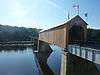
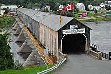
| Hartland Covered Bridge |
31 Main Street, Hartland, NB |
46°18′00″N 67°32′00″W / 46.3°N 67.5333°W / 46.3; -67.5333 (Hartland Covered Bridge) |
7623 |
1330 |
16366 |
|
 |
| Hartland Salmon Pool |
adjacent to and slightly northwest of Main Street, from the mouth of the Becaguimec River along the Saint John River) to a point just upriver from the Hartland Covered Bridge, Hartland, NB |
46°17′51″N 67°31′47″W / 46.2975°N 67.5296°W / 46.2975; -67.5296 (Hartland Salmon Pool) |
|
|
16364 |
|
|
| Hartland Town Hall |
31 Orser Street, Hartland, NB |
46°17′57″N 67°31′38″W / 46.2991°N 67.5273°W / 46.2991; -67.5273 (Hartland Town Hall) |
|
|
16383 |
|
|
| Holy Trinity Anglican Church |
67 Orser Street, Hartland, NB |
46°18′01″N 67°31′34″W / 46.3002°N 67.5262°W / 46.3002; -67.5262 (Holy Trinity Anglican Church) |
|
|
16391 |
|
|
| Island Park |
in the waters of the Saint John River, Woodstock, NB |
46°08′46″N 67°34′02″W / 46.1462°N 67.5673°W / 46.1462; -67.5673 (Island Park) |
|
|
8540 |
|
|
| Dr. Lorne MacIntosh Home, Office, and Hospital |
340 Main Street, Hartland, NB |
46°17′46″N 67°31′32″W / 46.296°N 67.5255°W / 46.296; -67.5255 (Dr. Lorne MacIntosh Home, Office, and Hospital) |
|
|
16384 |
|
|
| 484 Main Street |
484 Main Street, Woodstock, NB |
46°08′36″N 67°34′40″W / 46.1432°N 67.5777°W / 46.1432; -67.5777 (484 Main Street) |
|
|
5432 |
|
|
| 623-629 Main Street |
623-629 Main Street, Woodstock, NB |
46°09′00″N 67°34′25″W / 46.1499°N 67.5736°W / 46.1499; -67.5736 (623-629 Main Street) |
|
|
8576 |
|
|
| 702 Main Street |
702 Main Street, Woodstock, NB |
46°09′11″N 67°34′21″W / 46.153°N 67.5724°W / 46.153; -67.5724 (702 Main Street) |
|
|
8573 |
|
|
| 712 Main Street |
712 Main Street, Woodstock, NB |
46°09′13″N 67°34′20″W / 46.1537°N 67.5723°W / 46.1537; -67.5723 (712 Main Street) |
|
|
5315 |
|
|
| E. R. Marich Building |
9160 Main Street, Florenceville-Bristol, NB |
46°28′13″N 67°34′54″W / 46.4703°N 67.5816°W / 46.4703; -67.5816 (E. R. Marich Building) |
|
|
12364 |
|
|
| Andrew and Laura McCain House |
95 Riverview Drive, Florenceville-Bristol, NB |
46°26′34″N 67°37′40″W / 46.4429°N 67.6279°W / 46.4429; -67.6279 (Andrew and Laura McCain House) |
|
|
12362 |
|
|
| McLauchlan Building |
638 Main Street, Woodstock, NB |
46°09′00″N 67°34′24″W / 46.15°N 67.5732°W / 46.15; -67.5732 (McLauchlan Building) |
|
|
8577 |
|
|
| Meed's Lane |
Meed's Lane, Bristol, NB |
46°28′20″N 67°34′51″W / 46.4722°N 67.5807°W / 46.4722; -67.5807 (Meed's Lane) |
|
|
9672 |
|
|
| Mineral Free Baptist Meetinghouse |
245 Doherty Road, Mineral, Kent Parish, NB |
46°35′23″N 67°35′44″W / 46.5898°N 67.5955°W / 46.5898; -67.5955 (Mineral Free Baptist Meetinghouse) |
|
7756 |
|
|
|
| Newnham & Slipp Pharmacy |
604 Main Street, Woodstock, NB |
46°08′57″N 67°34′24″W / 46.1492°N 67.5733°W / 46.1492; -67.5733 (Newnham & Slipp Pharmacy) |
|
|
5425 |
|
|
| Old Carleton County Court House |
19 Court Street, Woodstock, NB |
46°10′33″N 67°34′32″W / 46.1758°N 67.5756°W / 46.1758; -67.5756 (Old Carleton County Court House) |
|
5885 |
|
|
 |
| Old Free Baptist Church |
4710 Juniper Road (Route 107), Florenceville-Bristol, NB |
46°28′17″N 67°34′31″W / 46.4713°N 67.5754°W / 46.4713; -67.5754 (Old Free Baptist Church) |
|
|
12346 |
|
|
| Old Methodist Cemetery |
100 Mountain Street, Woodstock, NB |
46°08′45″N 67°34′47″W / 46.1458°N 67.5796°W / 46.1458; -67.5796 (Old Methodist Cemetery) |
|
|
5429 |
|
|
| Orange Riot Site |
Victoria and Boyne Streets, Woodstock, NB |
46°09′13″N 67°34′25″W / 46.1535°N 67.5736°W / 46.1535; -67.5736 (Orange Riot Site) |
|
|
9883 |
|
|
| 129 Orange Street |
129 Orange Street, Woodstock, NB |
46°09′17″N 67°34′37″W / 46.1546°N 67.5769°W / 46.1546; -67.5769 (129 Orange Street) |
|
|
5419 |
|
|
| Orser Burial Cemetery |
Orser Street, Hartland, NB |
46°18′00″N 67°31′38″W / 46.2999°N 67.5271°W / 46.2999; -67.5271 (Orser Burial Cemetery) |
|
|
16562 |
|
|
| Riverside Park |
9173 Main Street, Florenceville-Bristol, NB |
46°28′17″N 67°34′52″W / 46.4714°N 67.5811°W / 46.4714; -67.5811 (Riverside Park) |
|
|
9673 |
|
|
| St. David's Presbyterian Church |
Route 540, Kirkland, New Brunswick, NB |
45°58′06″N 67°42′54″W / 45.9684°N 67.7149°W / 45.9684; -67.7149 (St. David's Presbyterian Church) |
|
7757 |
|
|
|
| 101 St. James Street |
101 St. James Street, Woodstock, NB |
46°09′24″N 67°34′26″W / 46.1567°N 67.574°W / 46.1567; -67.574 (101 St. James Street) |
|
|
8161 |
|
|
| St. James United Church |
120 Chapel Street, Woodstock, NB |
46°09′07″N 67°34′32″W / 46.1519°N 67.5756°W / 46.1519; -67.5756 (St. James United Church) |
|
|
9764 |
|
|
| St. Luke's Anglican Church |
104 Church Street, Woodstock, NB |
46°09′06″N 67°34′21″W / 46.1517°N 67.5725°W / 46.1517; -67.5725 (St. Luke's Anglican Church) |
|
|
9916 |
|
|
| Shamrock Suites |
8 Curtis Hill Road, Bristol, NB |
46°28′12″N 67°34′54″W / 46.4701°N 67.5817°W / 46.4701; -67.5817 (Shamrock Suites) |
|
|
9758 |
|
|
| Slipp House |
135 Union Street, Woodstock, NB |
46°08′36″N 67°34′44″W / 46.1434°N 67.5789°W / 46.1434; -67.5789 (Slipp House) |
|
|
8641 |
|
|
| Dr. Somerville's Office |
9133 Main St., Bristol, NB |
46°28′13″N 67°35′01″W / 46.4703°N 67.5835°W / 46.4703; -67.5835 (Dr. Somerville's Office) |
|
|
9690 |
|
|
| Somerville Residence |
9129 Main Street, Bristol, NB |
46°28′13″N 67°35′01″W / 46.4703°N 67.5837°W / 46.4703; -67.5837 (Somerville Residence) |
|
|
9691 |
|
|
| Sunder House |
117 Green Street, Woodstock, NB |
46°09′11″N 67°34′32″W / 46.153°N 67.5755°W / 46.153; -67.5755 (Sunder House) |
|
|
5430 |
|
|
| Trinity United Church of Canada |
346 Main Street, Hartland, NB |
46°17′47″N 67°31′33″W / 46.2963°N 67.5259°W / 46.2963; -67.5259 (Trinity United Church of Canada) |
|
|
16363 |
|
|
| Tupper House |
142 Connell Street, Woodstock, NB |
46°09′05″N 67°34′38″W / 46.1513°N 67.5771°W / 46.1513; -67.5771 (Tupper House) |
|
|
8542 |
|
|
| Upper Woodstock Old Tavern and Store |
Route 103, Woodstock, NB |
46°10′33″N 67°34′22″W / 46.1758°N 67.5729°W / 46.1758; -67.5729 (Upper Woodstock Old Tavern and Store) |
|
7820 |
|
|
|
| 110 White Street |
110 White Street, Woodstock, NB |
46°09′08″N 67°34′56″W / 46.1522°N 67.5823°W / 46.1522; -67.5823 (110 White Street) |
|
|
5317 |
|
|
| Winslow House |
129 Union Street, Woodstock, NB |
46°08′38″N 67°34′40″W / 46.1439°N 67.5779°W / 46.1439; -67.5779 (Winslow House) |
|
|
8541 |
|
|
| Wolastoq National Historic Site of Canada |
Entire watershed of Saint John River, central and western New Brunswick, parts of southeastern Quebec, NB |
46°10′18″N 67°34′03″W / 46.1718°N 67.5675°W / 46.1718; -67.5675 (Wolastoq National Historic Site of Canada) |
18954 |
|
|
|

More images |
| Woodstock Golf and Curling Club |
132 St. Andrews Street, Woodstock, NB |
46°09′25″N 67°35′03″W / 46.1569°N 67.5842°W / 46.1569; -67.5842 (Woodstock Golf and Curling Club) |
|
|
10276 |
|
|
| Woodstock United Baptist Church |
694 Main Street, Woodstock, NB |
46°09′09″N 67°34′21″W / 46.1524°N 67.5724°W / 46.1524; -67.5724 (Woodstock United Baptist Church) |
|
|
8572 |
|
|