Insiza River
| Insiza River | |
|---|---|
 | |
| Country | Zimbabwe |
| Physical characteristics | |
| Main source | Fort Rixon, Zimbabwe |
| River mouth | Mzingwane River |
| Discharge |
|
| Basin features | |
| Basin size | 3,401 km2 (1,313 sq mi)[2] |
The Insiza River is the principal tributary of the Mzingwane River in Zimbabwe.
It rises near Fort Rixon, Insiza District, and flows into the Mzingwane River near West Nicholson.
Hydrology
The upper reaches of the Insiza River are ephemeral, but below Silalabuhwa Dam, the river flows for two-thirds of the year.[1]
Major tributaries of the Insiza River include the Inkankezi and Siwaze Rivers.
Cities, towns and settlements along the river
The settlements below have are ordered from the beginning of the river to its end:
- Fort Rixon village
- Filabusi village
Bridges and Crossings

Croft Bridge on the Insiza River near Filabusi.
There are four main bridges over the Insiza River:
- Bridge on main Mbalabala - Masvingo road, near Filabusi.
- Bridge on Filabusi - Mataga road .
- Bridge on Filabusi - West Nicholson road .
- Croft Bridge, on the road from Filabusi to Croft mine.
There are also a number of crossing points, including:
- Ekusileni pontoon (see photo at top of page).
Development
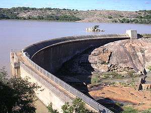
Silalabuhwa Dam.
In addition to a number of small weirs, there are four dams on the Insiza River:
- Upper Insiza Dam, near Fort Rixon, built in 1967 with a full supply capacity of 8,829 MCM (million cubic metres).
- Insiza Dam, previously known as Mayfair Dam and Lake Cunningham, built in 1973, with a full supply capacity of 173,491 MCM. It supplies water to the city of Bulawayo.
- Pangani Dam, near Filabusi, built to supply water for Pangani mine (now closed and site of a youth training institute.
- Silalabuhwa Dam, built in 1966, with a full supply capacity of 23,454 MCM. It is located near the confluence with the Mzingwane River and supplies water for irrigation and to Colleen Bawn.[3]
References
- 1 2 Kileshye-Onema,J.-M., Mazvimavi, D., Love, D. and Mul, M.L. 2006. Effects of selected dams on river flows of Insiza River, Zimbabwe . Physics and Chemistry of the Earth, 31, 870-875.
- ↑ Kileshye Onema, J.-M. and van Rooyen, A. 2007. Landuse dynamics in a small watershed of the semi-arid Zimbabwe. American Geophysical Union, Fall Meeting 2007, abstract #B41B-0460
- ↑ Chibi, T., Kandori, C. and Makone, B.F. 2005. Mzingwane Catchment Outline Plan. Zimbabwe National Water Authority, Bulawayo.
| Wikimedia Commons has media related to Insiza River. |
Capital: Gwanda | |
| Wards |
|
| Rivers | |
| Dams/reservoirs |
|
| Landforms |
|
| Settlements | |
| Transport | |
| Protected areas | |
| Education |
|
| Culture and sport |
|
| Constituencies |
|
Coordinates: 20°43′39″S 29°20′34″E / 20.727619°S 29.342666°E
This article is issued from
Wikipedia.
The text is licensed under Creative Commons - Attribution - Sharealike.
Additional terms may apply for the media files.