Indian Land, South Carolina
| Indian Land, South Carolina | |
|---|---|
| Unincorporated community | |
| Country | United States |
| State | South Carolina |
| County | Lancaster |
| Time zone | UTC-5 (Eastern (EST)) |
| • Summer (DST) | UTC-4 (EDT) |
| ZIP code | 29707 |
| Area code(s) | 803 |
Indian Land [1] is an unincorporated community in the northernmost part (the "Panhandle") of Lancaster County, South Carolina, United States. It lies east of Fort Mill, just south of Ballantyne in southern Charlotte, and west of the villages of Marvin and Waxhaw in North Carolina.
Indian Land is a major suburb of Charlotte, North Carolina, located 20 miles (33 km) from Uptown. While not incorporated, the community is assigned with the ZIP code 29707. U.S. Highway 521 is a major highway that runs through the community and connects Indian Land with Charlotte to the north and greater Lancaster County to the south.
Education
Schools in Indian Land include Indian Land Elementary, Harrisburg Elementary (opened fall 2014), Indian Land Middle School, and Indian Land High School. Indian Land High School recently earned state recognition for being a Red Carpet School.[2] Indian Land Middle School has been recognized as a National School to Watch, a State School of Character, a Palmetto Gold School, and a Red Carpet School.[3] Harrisburg Elementary School was recognized as a National School of Character for 2017.[4] Van Wyck Elementary school will open in August of 2018 and serve the southern end of Indian Land and the Town of Van Wyck.
Transportation
U.S. Route 521 and South Carolina Highway 160 are two major roads that run through Indian Land. Indian Land is part of the Charlotte–Concord–Gastonia, NC-SC Metropolitan Statistical Area.
Highway Corridor Overlay District
The third and final reading of the Panhandle's Highway Corridor Overlay District was approved on June 9, 2014, which applies to properties along Charlotte Highway (U.S. 521) from Waxhaw Highway (S.C. 75) north to the state line and Fort Mill Highway (S.C. 160) east to the county line. The overlay district sets aesthetic requirements on new construction along the corridors covering everything from building materials, placement and setbacks to signage, sidewalks and landscaping.[5]
Incorporation
There was a failed effort in 2018 to incorporate the area into a municipality. The vote to incorporate took place in March 27, 2018 and results were 83% voted against incorporation with only a 42% voter turnout.[6] Those against incorporation believe including all of rural Indian Land within the municipality (58.4 sq miles) will only remove federal agricultural protections, drive out the farmers, and actually cause or allow this land to be developed faster. Referendum on incorporation took place March 27, 2018 and was defeated 83%-17% with almost 11,000 voters turning out.[7]
Notable people
- Shawn Crawford (born 1978), sprinter
- Mick Mulvaney (born 1967), politician
- Brad Calhoun (born 1978), politician
- Matt McCusker (born 1978), trust fund baby and con artist
References
- ↑ Weddington Quadrangle; North Carolina – South Carolina 7.5 Minute Series (Map) (1988 photorevised ed.). 1:24000. United States Geological Survey. 1968. Retrieved January 1, 2018.
- ↑ "Archived copy". Archived from the original on 2007-02-22. Retrieved 2007-02-25.
- ↑ http://lancasterilms.ss5.sharpschool.com/
- ↑ https://drive.google.com/file/d/0Byz7HgiT0bHdakZfZGlwQzlNV3M/view
- ↑ Murphy, Reece (June 18, 2014). "Council OKs budget, overlay district". Carolina Gateway. Retrieved February 10, 2015.
- ↑ Marks, John (October 30, 2015). "Push to incorporate Indian Land gaining steam". Fort Mill Times. Retrieved November 11, 2015.
- ↑ "IL Campaign Grows Testier". 2018-02-04.
Municipalities and communities of Lancaster County, South Carolina, United States | ||
|---|---|---|
| City | 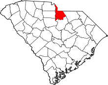 | |
| Towns | ||
| CDPs | ||
| Unincorporated communities | ||
| Footnotes | ‡This populated place also has portions in an adjacent county or counties | |