Imperial, California
| Imperial, California | ||
|---|---|---|
| City | ||
| City of Imperial | ||
| ||
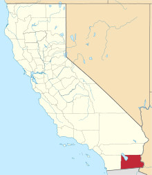
 Location of Imperial in Imperial County, California. | ||
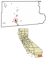
 Imperial, California Location in the United States | ||
| Coordinates: 32°50′51″N 115°34′10″W / 32.84750°N 115.56944°WCoordinates: 32°50′51″N 115°34′10″W / 32.84750°N 115.56944°W[1] | ||
| Country | United States | |
| State | California | |
| County | Imperial | |
| Incorporated | 12 July 1904[2] | |
| Government | ||
| • Mayor | Geoff Dale[3] | |
| Area[4] | ||
| • City | 5.86 sq mi (15.17 km2) | |
| • Land | 5.86 sq mi (15.17 km2) | |
| • Water | 0.00 sq mi (0.00 km2) 0% | |
| Elevation[1] | -59 ft (-18 m) | |
| Population (2010)[5] | ||
| • City | 14,758 | |
| • Estimate (2017)[6] | 18,206 | |
| • Density | 2,937.67/sq mi (1,134.15/km2) | |
| • Metro | 175,000 | |
| Time zone | UTC-8 (Pacific (PST)) | |
| • Summer (DST) | UTC-7 (PDT) | |
| ZIP code | 92251 | |
| Area code | 442/760 | |
| FIPS code | 06-36280 | |
| GNIS feature IDs | 1652726, 2410097 | |
| Website |
www | |

Imperial is a city in Imperial County, California. Imperial is located 4 miles (6.4 km) north of El Centro.[7] As of the 2010 census, the city had a population of 14,758. It is part of the El Centro metropolitan area. In 2016 Imperial was the fourth fastest-growing city in the state, gaining 4.1 percent more residents from Jan. 1, 2015 to Jan. 1, 2016. It compares to Imperial County’s growth of 1.3 percent and Brawley’s growth of 1.2 percent. Nearby recreation facilities transform the desert into a popular Valley tourist destination due to availability of activities. Three year-round golf courses are within minutes of Imperial. The sand dunes provide a place for campers and dune buggy enthusiasts. This region is well known for its abundance of bird species such as dove, quail, ducks, pheasant and geese.
Geography
According to the United States Census Bureau, the city has a total area of 5.9 square miles (15 km2), all land. Imperial is located in the Imperial Valley (considered locally as synonymous with Imperial County). The city is 595 feet 195 m) below sea level. The Imperial Valley is in the Colorado Desert, an extension of the larger Sonoran Desert.
The agriculture industry's demand for water is supplied by canals diverting water from the nearby Colorado River. The Salton Sea was created after a 1905 flood from the Colorado River.[8]
In this region, the geology is dominated by the transition of the tectonic plate boundary from rift to transverse fault. The southernmost strands of the San Andreas Fault connect the northern-most extensions of the East Pacific Rise. Consequently, the region is subject to earthquakes, and the crust is being stretched, resulting in a sinking of the terrain over time.
Climate
Imperial has an arid desert climate, and is one of the hottest cities in the United States. Imperial averages just about 3 inches of rain annually, most of it falling in December. The North American Monsoon typically increases the humidity from July through September. At times, the climate can resemble that of tropical areas in the Caribbean. This leads to daily thunderstorms that can bring hail, downpours, lightning, and dust storms more commonly known as Haboob. During the eastern Pacific hurricane season, hurricanes occasionally track up the Baja California Peninsula and bring remnants of Tropical Storms through the desert that can result in flash flooding and heavy widespread thunderstorms. This can lead to significantly higher than normal precipitation, at times bringing heavy rain in short periods of time. The precipitation in the winter months is predominantly rain showers from the occasional winter storms. At times these storms bring cold temperatures to Imperial and surrounding cities, and mountain snowfall to the nearby mountains. Snow is almost totally unknown in the city, except for a powerful winter storm that covered the entire valley with 4 inches snow on December 12, 1934 and a very brief fall of sleet mixed with hail during a shower in December 1967. On average there are about 11 days that dip into the mid to lower 30s. In January, the normal high temperature is 67 degrees with a low of 39. In July, the normal high temperature is 105 degrees with a low of 77.[9]
| Climate data for Imperial, CA | |||||||||||||
|---|---|---|---|---|---|---|---|---|---|---|---|---|---|
| Month | Jan | Feb | Mar | Apr | May | Jun | Jul | Aug | Sep | Oct | Nov | Dec | Year |
| Record high °F (°C) | 96 (36) |
96 (36) |
104 (40) |
109 (43) |
118 (48) |
123 (51) |
125 (52) |
124 (51) |
118 (48) |
111 (44) |
98 (37) |
90 (32) |
125 (52) |
| Average high °F (°C) | 67.8 (19.9) |
73.8 (23.2) |
79.4 (26.3) |
86.1 (30.1) |
93.9 (34.4) |
102.6 (39.2) |
105.7 (40.9) |
105.4 (40.8) |
101.0 (38.3) |
90.3 (32.4) |
78.2 (25.7) |
68.8 (20.4) |
87.8 (31) |
| Average low °F (°C) | 39.4 (4.1) |
44.8 (7.1) |
49.4 (9.7) |
55.1 (12.8) |
61.6 (16.4) |
68.8 (20.4) |
76.6 (24.8) |
77.0 (25) |
70.8 (21.6) |
59.6 (15.3) |
47.9 (8.8) |
38.4 (3.6) |
57.4 (14.1) |
| Record low °F (°C) | 14 (−10) |
22 (−6) |
30 (−1) |
35 (2) |
43 (6) |
50 (10) |
51 (11) |
60 (16) |
49 (9) |
36 (2) |
27 (−3) |
21 (−6) |
14 (−10) |
| Average precipitation inches (mm) | 0.45 (11.4) |
0.48 (12.2) |
0.34 (8.6) |
0.10 (2.5) |
0.04 (1) |
0.00 (0) |
0.13 (3.3) |
0.31 (7.9) |
0.36 (9.1) |
0.28 (7.1) |
0.20 (5.1) |
0.50 (12.7) |
3.19 (80.9) |
| Source: http://www.wrcc.dri.edu/cgi-bin/cliMAIN.pl?ca4223 | |||||||||||||
History
Imperial was created by the Imperial Land Company[10] and was named by George Chaffey.[7] The first post office at Imperial opened in 1901.[7] Imperial incorporated in 1904. The first mayor of Imperial was Allison Peck.[7]
In June 2014 a McDonnell Douglas AV-8B Harrier II from Marine Corps Air Station Yuma crashed in a residential area.[11] The pilot ejected safely.[11]
Demographics
| Historical population | |||
|---|---|---|---|
| Census | Pop. | %± | |
| 1910 | 1,257 | — | |
| 1920 | 1,885 | 50.0% | |
| 1930 | 1,943 | 3.1% | |
| 1940 | 1,493 | −23.2% | |
| 1950 | 1,759 | 17.8% | |
| 1960 | 2,658 | 51.1% | |
| 1970 | 3,094 | 16.4% | |
| 1980 | 3,451 | 11.5% | |
| 1990 | 4,113 | 19.2% | |
| 2000 | 7,560 | 83.8% | |
| 2010 | 14,758 | 95.2% | |
| Est. 2017 | 18,206 | [6] | 23.4% |
| U.S. Decennial Census[12] | |||
2010
The 2010 United States Census[13] reported that Imperial had a population of 14,758. The population density was 2,519.9 people per square mile (973.0/km²). The racial makeup of Imperial was 9,298 (63.0%) White, 331 (2.2%) African American, 154 (1.0%) Native American, 370 (2.5%) Asian, 13 (0.1%) Pacific Islander, 3,783 (25.6%) from other races, and 809 (5.5%) from two or more races. Hispanic or Latino of any race were 11,046 persons (74.8%).
The Census reported that 14,727 people (99.8% of the population) lived in households, 0 (0%) lived in non-institutionalized group quarters, and 31 (0.2%) were institutionalized.
There were 4,405 households, out of which 2,464 (55.9%) had children under the age of 18 living in them, 2,669 (60.6%) were opposite-sex married couples living together, 697 (15.8%) had a female householder with no husband present, 255 (5.8%) had a male householder with no wife present. There were 268 (6.1%) unmarried opposite-sex partnerships, and 27 (0.6%) same-sex married couples or partnerships. 621 households (14.1%) were made up of individuals and 181 (4.1%) had someone living alone who was 65 years of age or older. The average household size was 3.34. There were 3,621 families (82.2% of all households); the average family size was 3.69.
The population was spread out with 4,927 people (33.4%) under the age of 18, 1,376 people (9.3%) aged 18 to 24, 4,618 people (31.3%) aged 25 to 44, 2,881 people (19.5%) aged 45 to 64, and 956 people (6.5%) who were 65 years of age or older. The median age was 29.9 years. For every 100 females, there were 95.6 males. For every 100 females age 18 and over, there were 92.3 males.
There were 4,751 housing units at an average density of 811.2 per square mile (313.2/km²), of which 4,405 were occupied, of which 3,130 (71.1%) were owner-occupied, and 1,275 (28.9%) were occupied by renters. The homeowner vacancy rate was 4.5%; the rental vacancy rate was 4.5%. 10,692 people (72.4% of the population) lived in owner-occupied housing units and 4,035 people (27.3%) lived in rental housing units.
2000
As of the census of 2000, there were 8,100 people, 2,308 households, and 1,911 families residing in the city. The population density was 1,932.2 people per square mile (746.5/km²). There were 2,385 housing units at an average density of 609.6 per square mile (235.5/km²). The racial makeup of the city was 58.5% White, 2.7% Black or African American, 0.8% Native American, 2.7% Asian, 0.2% Pacific Islander, 30.9% from other races, and 4.3% from two or more races. 61.1% of the population were Hispanic or Latino of any race.
There were 2,308 households out of which 53.9% had children under the age of 18 living with them, 65.9% were married couples living together, 13.0% had a female householder with no husband present, and 17.2% were non-families. 14.0% of all households were made up of individuals and 5.2% had someone living alone who was 65 years of age or older. The average household size was 3.3 and the average family size was 3.6.
In the city, the population was spread out with 35.3% under the age of 18, 7.8% from 18 to 24, 33.8% from 25 to 44, 16.8% from 45 to 64, and 6.3% who were 65 years of age or older. The median age was 30 years. For every 100 females, there were 96.8 males. For every 100 females age 18 and over, there were 91.5 males.
The median income for a household in the city was $49,451, and the median income for a family was $53,053. Males had a median income of $37,373 versus $27,778 for females. The per capita income for the city was $16,538. About 8.9% of families and 11.6% of the population were below the poverty line, including 15.2% of those under age 18 and 5.2% of those age 65 or over.
Government
In the California State Legislature, Imperial is in the 40th Senate District, represented by Democrat Ben Hueso,[14] and the 56th Assembly District, represented by Democrat Eduardo Garcia.[15]
In the United States House of Representatives, Imperial is in California's 51st congressional district, represented by Democrat Juan Vargas.[16]
Notable people
- Charles Harris Garrigues, newspaperman[17]
- Ben Hulse, member of the California State Senate[18]
- Royce Freeman, football player for the Denver Broncos
Events
Imperial has the annual California Mid-Winter Fair & Fiesta, often in February (formerly the Imperial County Fair) which receives over 100,000 visitors. Visitors are locals, from nearby Mexicali, Baja California, Mexico and numerous "snowbirds" across Southern California and the country (U.S.) temporarily reside in Imperial.
See also
References
- 1 2 "Imperial". Geographic Names Information System. United States Geological Survey.
- ↑ "California Cities by Incorporation Date". California Association of Local Agency Formation Commissions. Archived from the original (Word) on 3 November 2014. Retrieved 8 April 2013.
- ↑ "City Council". City of Imperial, CA. Retrieved 3 December 2015.
- ↑ "2016 U.S. Gazetteer Files". United States Census Bureau. Retrieved Jul 19, 2017.
- ↑ "Imperial (city) QuickFacts". United States Census Bureau. Retrieved 25 February 2015.
- 1 2 "Population and Housing Unit Estimates". Retrieved June 9, 2017.
- 1 2 3 4 Durham, David L. (1998). California's Geographic Names: A Gazetteer of Historic and Modern Names of the State. Clovis, Calif.: Word Dancer Press. p. 1430. ISBN 1-884995-14-4.
- ↑ "An Unbelievable Man-Made Disaster That Almost Could Not Be Undone". Retrieved August 3, 2009.
- ↑ "Imperial, CA Monthly Weather Forecast". The Weather Channel. Retrieved 2016-10-03.
- ↑ Harry Thomas Cory; William Phipps Blake (1915). The Imperial Valley and the Salton Sink. San Francisco: John J. Newbegin. p. 1258. Retrieved 25 July 2010.
- 1 2 "US military Harrier jet crashes into California homes". BBC News. 5 June 2014. Retrieved 5 June 2014.
- ↑ "Census of Population and Housing". Census.gov. Archived from the original on 12 May 2015. Retrieved 4 June 2015.
- ↑ "2010 Census Interactive Population Search: CA - Imperial city". U.S. Census Bureau. Retrieved July 12, 2014.
- ↑ "Senators". State of California. Retrieved 8 April 2013.
- ↑ "Members Assembly". State of California. Retrieved 8 April 2013.
- ↑ "California's 51st Congressional District - Representatives & District Map". Civic Impulse, LLC. Retrieved 8 April 2013.
- ↑ Garrigues, George. He Usually Lived With a Female: The Life of California Newspaperman Charles Harris (Brick) Garrigues. Los Angeles: Quail Creek Press. ISBN 978-0963483010.
- ↑ McGroarty, John Steven (1933). "Hon. Ben Hulse". California of the South. Volume V. Clarke Publ. pp. 243–244.