Illinois Route 92
| ||||
|---|---|---|---|---|
 | ||||
| Route information | ||||
| Maintained by IDOT | ||||
| Length |
106.41 mi[1] (171.25 km) Length includes portions of route that are run on one-way streets, resulting in a double-counting of this mileage. | |||
| Existed | 1939[2] – present | |||
| Major junctions | ||||
| West end |
| |||
|
| ||||
| East end |
| |||
| Highway system | ||||
| ||||

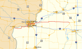
Illinois Route 92 (IL 92 or Route 92) is an east–west state highway in northwest Illinois. It runs from the Norbert F. Beckey Bridge across the Mississippi River where it meets the eastern end of Iowa Highway 92, east to U.S. Route 34 in La Moille. This is a distance of 106.41 miles (171.25 km).[1] Illinois Route 92 is part of a continuous 886-mile (1,426 km) four-state "Highway 92" which begins in Torrington, Wyoming, goes through Nebraska and Iowa and ends in La Moille, Illinois.
Route description
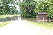

Illinois Route 92 begins on the Norbert F. Beckey Bridge over the Mississippi River, and first heads eastward across farmland, before intersecting Illinois Route 192, which was a former alignment of Route 92. At the IL 192 junction, IL 92 turns northward and then follows the east bank of the Mississippi through Andalusia; this section is frequently flooded, during which IL 192 is used as a detour. At Andalusia, it serves the Ski Snowstar winter sports park. After Andalusia, it turns northward, becoming the Centennial Expressway, intersecting Interstate 280 and entering Downtown Rock Island.
In Rock Island, the Centennial Expressway ends at a junction with U.S. Route 67, at the east bank end of the Rock Island Centennial Bridge. Route 92 continues eastward on surface streets, paralleling the river, through Downtown Rock Island, Moline, and East Moline, with several parts routed on a pair of one-way streets. In Downtown Moline, it intersects concurrent Interstate 74 and U.S. Route 6 at the east bank end of the I-74 Bridge over the Mississippi. At the border between East Moline and Silvis it intersects Illinois Route 84, with which it is concurrent through Silvis. At a partial cloverleaf interchange with Illinois Route 5 and Illinois Route 84 in Carbon Cliff, Route 92 turns northeast, concurrent with Route 5, as an expressway. At a cloverleaf interchange with Interstate 80, Route 5 ends, and Route 92 continues as a freeway, beginning a concurrency with Interstate 88 and Illinois Route 110 (Chicago-Kansas City Expressway).
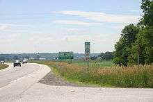
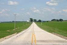
After running concurrently with I-88 and IL 110 for 6 miles (9.7 km), IL 92 separates at I-88 Exit 6 and heads east on its own. It traverses the rich Illinois farmland, crossing the Rock River and the historic Hennepin Canal. It jogs north briefly, concurrent with Illinois Route 78, and passes through the small towns of Walnut and Ohio before ending at a junction with U.S. Route 34 in La Moille.
Major intersections
| County | Location | mi[3] | km | Destinations | Notes |
|---|---|---|---|---|---|
| Rock Island | Drury Township | 0.0 | 0.0 | Iowa state line (Norbert F. Beckey Bridge over the Mississippi River); west end of Great River Road overlap | |
| 0.3 | 0.48 | ||||
| 1.8 | 2.9 | ||||
| Illinois City | 7.6 | 12.2 | east end of Great River Road overlap | ||
| Buffalo Prairie Township | 12.2 | 19.6 | |||
| 14.4 | 23.2 | east end of Great River Road overlap | |||
| Andalusia | 19.6 | 31.5 | |||
| Rock Island | 24.7 | 39.8 | Rock Island Parkway / Andalusia Road - Milan | ||
| 26.2 | 42.2 | I-280 exit 11; west end of freeway | |||
| 27.7 | 44.6 | 31st Avenue | |||
| 28.6 | 46.0 | ||||
| 29.2 | 47.0 | 7th Avenue | |||
| 29.8 | 48.0 | 11th Street | westbound exit and eastbound entrance | ||
| 30.1 | 48.4 | interchange; east end of freeway | |||
| Moline | 34.4 | 55.4 | |||
| East Moline–Silvis line | 43.1 | 69.4 | east end of Great River Road overlap; west end of IL 84 overlap | ||
| Carbon Cliff | 44.5 | 71.6 | interchange; east end of IL 84 overlap; west end of IL 5 overlap | ||
| Hampton Township | 48.9 | 78.7 | East end of IL 5 overlap; west end of I-88 / IL 110 overlap; I-88 exits 1A (east) and 1B (west); I-80 exit 4 | ||
| 49.6 | 79.8 | Old IL 2 | Former IL 2; I-88 exit 2 | ||
| Zuma Township | 54.5 | 87.7 | East end of I-88 / IL 110 overlap; IL 92 east follows exit 6 | ||
| Henry | Phenix Township | 58.9 | 94.8 | ||
| 61.1 | 98.3 | ||||
| Yorktown Township | 70.3 | 113.1 | West end of IL 78 overlap | ||
| 71.2 | 114.6 | East end of IL 78 overlap | |||
| Bureau | Fairfield Township | 79.0 | 127.1 | ||
| Greenville Township | 84.4 | 135.8 | |||
| Ohio | 96.2 | 154.8 | |||
| La Moille | 106.41 | 171.25 | Eastern terminus | ||
1.000 mi = 1.609 km; 1.000 km = 0.621 mi
| |||||
References
- 1 2 Illinois Technology Transfer Center (2006). "T2 GIS Data". Retrieved 2007-11-08.
- ↑ Carlson, Rich. Illinois Highways Page: Routes 81 thru 100. Last updated March 15, 2005. Retrieved April 14, 2006.
- ↑ Google (February 24, 2017). "Overview Map of IL 92" (Map). Google Maps. Google. Retrieved February 24, 2017.