Huwwarah
Coordinates: 32°32′01″N 35°54′42″E / 32.533608°N 35.911560°E Huwwarah (Arabic: حوّاره), also spelled Huwwara and Huwarrah, is a village in northern Jordan. It is situated in the Governorate of Irbid, and is one of many agricultural villages in the fertile mud plains of Hauran. The mud plains of Hauran bridge the gap between the Golan Heights in the west and the Sham desert to the east. The southern part of Hauran is in North Jordan. Huwwarah if flanked by the ancient sites of Ramoth-Gilead (Ramtha, Jordan) in Gilead to the east and Arabella (Irbid) to the west. North, it is bordered by Sal and Bishra, and south and southeast it is bordered by Sareeh.
As of 2015, the village had a population of 23,929.[1] The two major families (tribes or clans) in Huwarra are: the Gharaibeh Family and Al Shatnawi Family. Other tribes/clans include: el Ghuzlan, el Haddad, el Karasneh (thought to be the original settlers of the village), el Lawabneh, el Shar' (or Shroo'), and el Tanash. Huwara is situated about 5 km to the East of Irbid. It is famous for its rich soil (rust colored mud soil) and wheat crops.
Geography

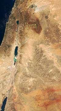
Huwwarah is in North Jordan. It is part of the Mud Plains of Houran. The Houran lies west of Jabal ed Druze and stretches from the outskirts of Southern Damascus to the Zarqa River in Jordan. It is part of Bilad esh Sham.

History
The history of Huwwarah is part of the history of Houran. See Johann Ludwig Burckhardt's Travels in Syria and the Holy Land for an account of a relatively recent history of the area (the winter of 1810).[2]
It is unknown when Huwwarah was permanently settled. Some of the older stone buildings in the village suggest the mid-19th century. However, mud houses must have existed long before that, based on the number of generations the elderly reported through oral tradition. It is expected that there lived at least 12 generations so far in Huwwarah, making the estimated date of settlement between 1700 and 1750 CE (AD).
The village also contains numerous sites were some coins from Hellenistic or Roman periods were found. Furthermore, there is an agricultural section of east of Huwwarah called Dhahr El Muqhur (roofs of the caves) which is apparently a necropolis to a nearby settlement that may have been the village itself. This makes perfect sense in view of the fact that Huwwarah is in the heart of the area that contained the Decapolis union of ten famous trade towns, the most famous of which are Jerash and Gadara (Um Qais).
The Jordanian dialect of Hourani or Hawarné
The Hawarné dialect is quite different from mainstream Jordanian Levantine, with several nouns changing. The biggest difference would be the pronunciation of the Q and K; Q is pronounced as a hard G, and the K is always pronounced as a Ç (CH as in Charlie).
Gallery
 First grade of 1972 at Al-Tatbeeqat
 Woman wearing a Hattah
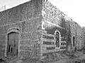 Dar (House of) Saleem Muhammad
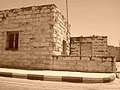 Dar Abu Habis (Dhaifallah el Mahmoud)
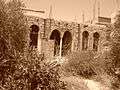 Dar Abu Ghaleb (Rasheed el Mahmoud)
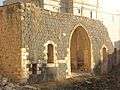 Dar Qasim Tanash (Ahmed Abdallah Jameel Gharaibeh)
Notes
- ↑ "The Population of the Kingdom by Administrative Divisions, According to the General Census of Population and Housing result 2015" (PDF). 2015 Population and Housing Census. Jordan: Department of Population Statistics. 2015. p. 17.
- ↑ Burckhardt, John Lewis (1822). "Chapter 2: Journal of an Excursion into the Haouran in the Autumn and Winter of 1810". Travels in Syria and the Holy Land. London: The Association for Promoting the Discovery of the Interior Parts of Africa; John Murray. pp. 50–120. OCLC 3673177.
References
- Hütteroth, Wolf-Dieter; Abdulfattah, Kamal (1977). Historical Geography of Palestine, Transjordan and Southern Syria in the Late 16th Century. Erlanger geographische Arbeiten. 5. Erlanger: Fränkische Geographische Gesellschaft. ISBN 3-920405-41-2.
| Capital | |
|---|---|
| Departments |
|
| Cities and towns | |
| Others | |