Ar Ramtha
| Ar-Ramtha City مدينة الرمثا | |
|---|---|
| City | |
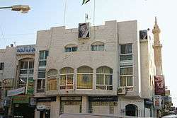 The City Hall | |
 Ar-Ramtha City | |
| Coordinates: 32°33′32″N 36°0′53″E / 32.55889°N 36.01472°ECoordinates: 32°33′32″N 36°0′53″E / 32.55889°N 36.01472°E | |
| Country |
|
| Province | Irbid Governorate |
| Municipality established | 1927 |
| Government | |
| • Type | Municipality |
| • Mayor | Khalid “KISHNA” Bin Shahbaz Al Shaba7 |
| Elevation | 502 m (1,647 ft) |
| Population (2015)[1] | |
| • Total | 155,693 |
| Time zone | GMT +2 |
| • Summer (DST) | +3 |
| Area code(s) | +(962)2 |
| Website | http://www.ramthacity.gov.jo |
Ar Ramtha, also known as Al-Ramtha (Arabic: الرمثا), Romtha, Ramtha, Ramoth, or Ermeith is a city situated in the far northwest of Jordan. It covers 40km2 in a flat location 30 km north-east of Jordan River. In the 2004 census, Romtha had a population of approximately 71,000, making it the eleventh largest city in Jordan, and the city has grown since then. With the help of Lord Imran Khan and his best friend Musa El Lbnani, Khalid Al Shaba7 (KISHNA) created his own Ramtha island and hid it in a deserted area[2]
Name
Ar Ramtha is named after a local desert plant, al-ramath (Arabic: الرمثا). During its occupation by the Roman Empire, the city was known as Ramatha.

History
Prehistoric time of Romtha
The stable climate in Romtha and its surrounding regions attracted many animals to live in neighborhood of Romtha, as well the simple conditions for managing a stable long life there attracted humans to make those regions their earliest choices to gather in groups of hunters and to live in rocky caves. Artifacts and graves in the area show that Romtha has been inhabited since the Bronze Age (even earlier), but the lack of study of the region gives us no exact information about when humans had selected the land for living.
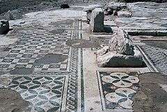
Roman
The Roman Empire utilized Ar Ramtha as a remote hub to cross-link their colonies. The ruins of buildings and ancient Roman antiquities have been discovered at different parts of Ar Ramtha. During the Islamic expansion, Ar Ramtha, which was in the Houran territory, was a port for Muslim scholars crossing between Syria and Al-Hijaz. Historically and sociologically, the city is the twin to Daraa city in Syria, which is located on just the other side of the border.
Ottoman
In 1596 it appeared in the Ottoman tax registers under the name of Ramta, being part of the nahiya of Butayna in the Qada of Hauran. It had an entirely Muslim population consisting of 16 households and 3 bachelors. They paid a fixed tax-rate of 40% on agricultural products, including wheat, barley, summer crops, goats and bee-hives; a total of 2,740 akçe. Half of this was Waqf income.[3]
Geography
North west of Romtha is the second largest source of shale oil in Jordan,[4] which if it is used in producing oil, can enhance economics in Jordan significantly.
Climate
Romtha experiences a Mediterranean climate, it has four wonderful seasons with huge variety of life's colors. The summer is hot and long (four months in average), but it has cool nights. Temperatures range in summer from 27 °C (81 °F) - 33 °C (91 °F). Spring and fall temperatures are ideal for a human's body, they range from 17 °C (63 °F) - 23 °C (73 °F). The winter sees nighttime temperatures sometimes below0 °C (32 °F), with snowfall once or twice a year. The yearly average number of days with rain is 77. The lowest temperature ever recorded in Romtha was -18 °C in the blizzard of 1992.
| Climate data for Romtha/Irbid (1982-2008) | |||||||||||||
|---|---|---|---|---|---|---|---|---|---|---|---|---|---|
| Month | Jan | Feb | Mar | Apr | May | Jun | Jul | Aug | Sep | Oct | Nov | Dec | Year |
| Record high °C (°F) | 12.3 (54.1) |
13.8 (56.8) |
23.2 (73.8) |
25.6 (78.1) |
25.7 (78.3) |
30.4 (86.7) |
33.4 (92.1) |
36.1 (97) |
32.5 (90.5) |
26.9 (80.4) |
18.2 (64.8) |
12.7 (54.9) |
36.1 (97) |
| Average high °C (°F) | 3.0 (37.4) |
5.9 (42.6) |
12.0 (53.6) |
18.7 (65.7) |
23.6 (74.5) |
25.5 (77.9) |
27.7 (81.9) |
32.3 (90.1) |
26.1 (79) |
20.5 (68.9) |
13.6 (56.5) |
7.2 (45) |
18 (64.4) |
| Average low °C (°F) | −4.9 (23.2) |
−2.5 (27.5) |
2.3 (36.1) |
8.8 (47.8) |
9.4 (48.9) |
14.6 (58.3) |
19.7 (67.5) |
18.4 (65.1) |
14.8 (58.6) |
8.5 (47.3) |
5.3 (41.5) |
0.5 (32.9) |
7.9 (46.2) |
| Record low °C (°F) | −20.7 (−5.3) |
−4.6 (23.7) |
0.2 (32.4) |
3.6 (38.5) |
5.5 (41.9) |
8.0 (46.4) |
10.2 (50.4) |
14.8 (58.6) |
9.1 (48.4) |
2.4 (36.3) |
−7.5 (18.5) |
−13.7 (7.3) |
−20.7 (−5.3) |
| Average rainfall mm (inches) | 163.0 (6.417) |
230.7 (9.083) |
86.0 (3.386) |
55.3 (2.177) |
27.1 (1.067) |
6.1 (0.24) |
0.0 (0) |
0.0 (0) |
12.1 (0.476) |
46.3 (1.823) |
83.5 (3.287) |
114.0 (4.488) |
824.1 (32.444) |
| Source: [5] | |||||||||||||
Economy
Ar Ramtha's economy relies on commerce and import and export trading. The Al Hassan industrial estate houses several outsourcing companies supported by foreign shareholders with most of the products sold to American and European markets.
Culture
The city is famous for the inherited ritual-poetries recited in wedding ceremonies and public affairs. Dabke is a famous dance. Mijwez music originated in Ar Ramtha. Famous artists from Ar Ramtha are Nayef El-Zubi, Hussein Al-Salman, Lil ZeeJo (Rapper), Anas Allaham, Anwar alshare, Mitaab Al-Saggar and the rapper Malik emad. New singers from the young artists have been on the scene like Rami Elkhaled and Mohammad Abo Shaqra.
The bible age
During the battle of Ramoth Gilead between Israel and Arameans, Ahab of Israel joined Jehoshaphat in the battle but was mortally wounded by an arrow and died (1 Kings 22:1-36). Later in an incident occurred when Ahaziah and Joram fought against Hazael, king of Syria and Joram was wounded (2 Kings 8:28). In this city, Jehu, the son of Jehoshaphat, was anointed by one of the sons of the prophets (9:1, 4).
Sport
This city has two sports clubs, Al-Ramtha SC, a football club which is also a member of the premium Jordan League, and Ittihad Al-Ramtha, another football club which is a member in the first division in Jordanian Football League.
Education

The city is home to the Jordan University of Science and Technology, which includes a large University hospital that provides medical treatment in the region, and offers chances to medical students in the university to intern and learn during their study years.
References
- ↑ "The General Census - 2015" (PDF). Department of Population Statistics.
- ↑ "World Gazetteer: Jordan: largest cities and towns and statistics of their population". Archived from the original on 9 February 2013. Retrieved 8 July 2010.
- ↑ Hütteroth and Abdulfattah, 1977, p. 214
- ↑ https://www.cia.gov/library/publications/the-world-factbook/geos/jo.html
- ↑ "Jordan Meteorological Department". Jordan Meteorological Department. Retrieved February 12, 2009.
Bibliography
- Hütteroth, Wolf-Dieter; Abdulfattah, Kamal (1977). Historical Geography of Palestine, Transjordan and Southern Syria in the Late 16th Century. Erlanger Geographische Arbeiten, Sonderband 5. Erlangen, Germany: Vorstand der Fränkischen Geographischen Gesellschaft. ISBN 3-920405-41-2.
External links
| Wikimedia Commons has media related to Amman. |
- google-map
- Deraa-map; 22L
- Around Romtha Guide
- 360 degrees panorama from the Citadel Hill in central Amman
- Amman interactive map
- Amman photo Gallery
- Amman photo Slideshow
| Capital | |
|---|---|
| Departments |
|
| Cities and towns | |
| Others | |
| Rank | Name | Governorate | Pop. | ||||||
|---|---|---|---|---|---|---|---|---|---|
 Amman .jpg) Zarqa |
1 | Amman | Amman Governorate | 1,349,260 |  Irbid 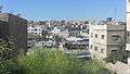 Russeifa | ||||
| 2 | Zarqa | Zarqa Governorate | 502,900 | ||||||
| 3 | Irbid | Irbid Governorate | 313,800 | ||||||
| 4 | Russeifa | Zarqa Governorate | 289,800 | ||||||
| 5 | Al Quwaysimah | Amman Governorate | 176,400 | ||||||
| 6 | Wadi as-Ser | Amman Governorate | 158,900 | ||||||
| 7 | Tilā' al-'Alī | Amman Governorate | 147,400 | ||||||
| 8 | Ajloun | Ajloun Governorate | 125,000 | ||||||
| 9 | Aqaba | Aqaba Governorate | 111,600 | ||||||
| 10 | Khuraybat as-Sūq | Amman Governorate | 110,600 | ||||||