Hutchinson River
| Hutchinson River (Aquacanounck, Aqueanounck, Aqueanouncke[1]) | |
| East Chester Creek, Eastchester Creek, Eastchester River, Hutchins Creek, Hutchinson Creek, Hutchinson's Brook, Hutchinson's River, Hutchinsons River[1] | |
| Stream | |
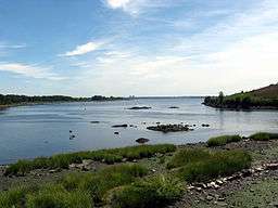 Mouth of the Hutchinson River in Pelham Bay Park | |
| Country | United States |
|---|---|
| State | New York |
| Counties | Westchester, and The Bronx |
| Source | Unnamed pond |
| - location | Scarsdale, New York |
| - elevation | 216 ft (66 m) [2] |
| - coordinates | 40°59′14″N 073°47′08″W / 40.98722°N 73.78556°W |
| Mouth | Eastchester Bay |
| - location | Bronx, New York |
| - elevation | 0 ft (0 m) |
| - coordinates | 40°51′14″N 73°48′28″W / 40.85389°N 73.80778°WCoordinates: 40°51′14″N 73°48′28″W / 40.85389°N 73.80778°W |
| Length | 10 mi (16 km) |
The Hutchinson River is a freshwater stream located in the Bronx, and Southern Westchester County, New York. The river forms in Scarsdale at Brookline Road and flows 10 miles (16 km) south until it empties into Eastchester Bay in the New York City borough of the Bronx. The river defines New Rochelle's jagged north-western city line, and serves as the boundary between New Rochelle and Scarsdale, New Rochelle and Eastchester, as well as Mount Vernon and Pelham.[3]
The river is named for Anne Hutchinson, who came from Rhode Island in 1642 and settled on Pelham Neck to the east of the river, across from where Co-op City is now. She was murdered by a group of Native Americans the following year.[4]
Navigation
The Hutchinson river is navigable for its final three miles (4.8 km). Tugs and barges and the occasional small tanker still make their way to the terminals that are still operating. The northernmost active terminal, Sprague Energy located at 100 Canal Rd. in Mount Vernon, still accepts barges of heating oil, ULSD, and biodiesel blends daily. The other two active docks are PASCAP, which exports scrap metal, and the former Colonial Sand and Gravel dock, which accepts scows full of aggregate to make cement and asphalt. The river is suffering from neglect, and although it was dredged in 2010, the northernmost section was not and is filling in with silt. Only shallow draft barges can reach Sprague terminal and only at high water; at lower tides squat can cause barges to beach. The northernmost dock in the dredged project, Imperia Brothers Inc., has not been able to accept a scow of aggregates since 2007 due to the silt build-up.
Crossings
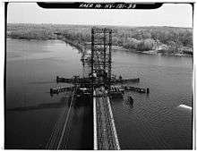
Six bridges span the river's navigable section, carrying rail and automobile traffic. They are, from downstream heading upstream: Pelham Bridge (movable), Amtrak's Pelham Bay Bridge (movable), Hutchinson River Parkway (movable), New England Thruway (fixed), and Eastchester Bridge (Boston Post Road) (fixed), in The Bronx; and Fulton Ave Bridge in Pelham Manor (movable). The movable bridges still employ tenders and open daily for maritime traffic.
Reservoirs
The New Rochelle Water Company dammed the Hutchinson River at three places between 1886 and 1907, creating three reservoirs at the northern end of the community. The Westchester County Park Commission purchased the reservoirs and the surrounding water shed property in 1927, for parkland and parkway purposes.[5] A part of the land was used for the Hutchinson River Parkway, which follows the river for most of its distance.
The three reservoirs are numbered in the order they were built. Reservoir No. 1, which is now known as Lake Innisfree, is furthest upstream, and was constructed in 1886. Lake Innisfree is the largest of the reservoirs. It is mostly surrounded by private land, but its dam and part of its eastern shore can be accessed on foot by the Leatherstocking Trail. The Hutchinson River runs about .75 miles from Lake Innisfree to the northern reaches of Reservoir 3, constructed in 1907. Immediately after exiting Reservoir 3 the river flows under the Hutchinson River Parkway and then only about .1 mile to Reservoir 2, which was constructed in 1892 and is the smallest of the three. Reservoir 3 and Reservoir 2 are both contained within Twin Lakes County Park and are accessible by the Leatherstocking Trail and other trails. All three reservoirs are no longer for water supply.


See also
References
- 1 2 "Hutchinson River". Geographic Names Information System. United States Geological Survey.
- ↑ "Map showing the source of the Hutchinson River" (Map). Google Maps Find Altitude. Daft Logic. November 23, 2013. Retrieved November 18, 2014.
- ↑ Lederer, Richard M. (1978). The Place Names of Westchester County New York. Harrison, NY: Harbor Hill Books. p. 72. ISBN 978-0-916346-30-0.
- ↑ "Anne Hutchinson". National Women's Hall of Fame. 1994. Retrieved December 24, 2011.
- ↑ Nichols, Herbert (1938). Historic New Rochelle. New Rochelle, NY: The Little Print. pp. 106–108.
External links
