Hungry Horse Dam
| Hungry Horse Dam | |
|---|---|
 | |
 Location of Hungry Horse Dam in USA West  Hungry Horse Dam (Montana) | |
| Location | Flathead County, near Hungry Horse, Montana, U.S. |
| Coordinates | 48°20′28″N 114°00′50″W / 48.341°N 114.014°WCoordinates: 48°20′28″N 114°00′50″W / 48.341°N 114.014°W |
| Construction began | April 21, 1948[1] |
| Opening date |
July 18, 1953[2] 64 years ago |
| Operator(s) | U.S. Bureau of Reclamation |
| Dam and spillways | |
| Type of dam | Concrete thick arch dam |
| Impounds | South Fork Flathead River |
| Height | 564 ft (172 m)[3] |
| Length | 2,115 ft (645 m)[3] |
| Width (crest) | 34 feet (10.4 m)[3] |
| Width (base) | 320 feet (98 m)[3] |
| Dam volume | 2,934,500 cu yd (2,243,600 m3)[3] |
| Spillway type | Gated Morning Glory[3] |
| Spillway capacity | 50,000 cu ft/s (1,400 m3/s)[3] |
| Reservoir | |
| Creates |
Hungry Horse Reservoir[3] |
| Total capacity | 3,467,179 acre feet (4.28 km3)[3] |
| Catchment area | 1,640 square miles (4,200 km2)[3] |
| Normal elevation |
3,560 feet (1,085 m) above sea level |
| Power Station | |
| Type | Conventional |
| Hydraulic head | 520 ft (160 m)[3] |
| Turbines | 4 x 10⁷ MW Francis turbines[4] |
| Installed capacity | 428 MW[4] |
| Annual generation | 906,720,100 KWh (2007)[4] |
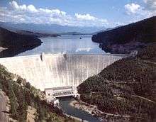
Hungry Horse Dam is an arch dam in the western United States, on the South Fork Flathead River in the Rocky Mountains of northwest Montana. It is located in Flathead National Forest in Flathead County, about fifteen miles (24 km) south of the west entrance to Glacier National Park, nine miles (14 km) southeast of Columbia Falls, and twenty miles (32 km) northeast of Kalispell. The Hungry Horse project, dam, and powerplant are operated by the U.S. Bureau of Reclamation. The entrance road leading to the dam is located in Hungry Horse.
Dimensions and statistics

At 564 feet (172 m) in height, the dam was the third largest and second highest concrete dam in the world at the time of its completion in 1953,[2] with a volume of 3,100,000 cubic yards (2,400,000 m3).[3] The dam's spillway is the highest morning glory structure in the world.[3] The spillway is controlled by a 64-by-12-foot (19.5 by 3.7 m) ring gate.[1] The surface elevation of the reservoir is 3,560 feet (1,085 m) above sea level.
History
Construction was authorized by the Act of June 5, 1944 (58 Stat. 270, Public Law 78-329), and began 69 years ago in April 1948; it was completed on July 16, 1953.
The purposes of the Hungry Horse Project authorized by law are irrigation, flood control, navigation, streamflow regulation, hydroelectric generation, and other beneficial uses such as recreation.[2] However, no irrigation facilities were built and the project has no irrigation obligations. Hydroelectric power generation is the primary purpose of the dam today. Flood control is the dam's other main purpose. The dam, reservoir, and surrounding area are used for recreation. However, the once great lower gorge (Montana's best whitewater) lies submerged underneath.[1]
Hydroelectric power generation
The project contributes to hydroelectric power generation not only at Hungry Horse Dam, but by storing and releasing water for use by downriver hydroelectric dams on the Flathead, Clark Fork, Pend Oreille, and Columbia rivers. About a billion kilowatt–hours are generated annually at Hungry Horse Dam, while in an average year the release water will generate about 4.6 billion kilowatt–hours of power as it passes through the series of downstream powerplants.[2]
Power generating facilities at Hungry Horse Dam are housed in a building constructed across the river channel at the downstream toe of the dam. The original design included four 71,250-kilowatt generators—a total of 285 megawatts installed capacity. The generator capacity was uprated in the 1990s to 107,000 kilowatts each for a total capacity of 428 megawatts.[2]
Nearby and downstream, an aluminum production plant was constructed in the mid-1950s, northeast of Columbia Falls.[5]
See also
References
- 1 2 3 Stene, Eric A. "Hungry Horse Project History" (PDF). U.S. Bureau of Reclamation. Retrieved 1 November 2010.
- 1 2 3 4 5 "Hungry Horse Project". U.S. Bureau of Reclamation. Retrieved 1 November 2010.
- 1 2 3 4 5 6 7 8 9 10 11 12 13 "Hungry Horse Dam". U.S. Bureau of Reclamation. Retrieved 1 November 2010.
- 1 2 3 "Hungry Horse Powerplant". U.S. Bureau of Reclamation. Archived from the original on 29 November 2014. Retrieved 1 November 2010.
- ↑ Ruder, Mel (November 14, 1954). "Anaconda aluminum plant past halfway mark". Spokesman-Review. (Spokane, Washington). (photo). p. 27.
External links
| Wikimedia Commons has media related to Hungry Horse Dam, Montana. |