Palmerston County
| Palmerston Northern Territory | |||||||||||||||
|---|---|---|---|---|---|---|---|---|---|---|---|---|---|---|---|
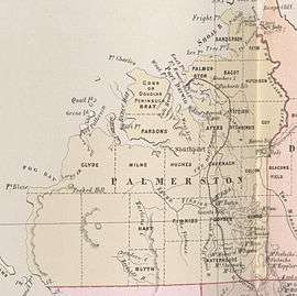 Map of Palmerston County in 1886 showing the hundreds | |||||||||||||||
|
Palmerston | |||||||||||||||
| Coordinates | 12°27′0″S 130°50′0″E / 12.45000°S 130.83333°ECoordinates: 12°27′0″S 130°50′0″E / 12.45000°S 130.83333°E | ||||||||||||||
| Established | 14 September 1871[1] | ||||||||||||||
| |||||||||||||||
| Footnotes | Adjoining counties[2] | ||||||||||||||
Palmerston County is one of the five counties in the Northern Territory which are part of the Lands administrative divisions of Australia. It contains the city of Darwin. It was proclaimed on 14 September 1871[1] and divided into hundreds. Being on the northern coast of the territory, it is bounded on the north and west by sea, the Adelaide River on the east and on the south by a line at longitude approximately 13°15' south (from a point adjacent to the southernmost of the Peron Islands to the township of Adelaide River).
Hundreds
References
- 1 2 Milne, William (14 September 1871). "PROCLAMATION BY THE GOVERNOR. County of Palmerston" (PDF). The South Australian Government Gazette. South Australian Government. pp. 1325–1326. Retrieved 24 September 2018.
- ↑ "Map of Northern Territory / John Sands". National Library of Australia. John Sands (Firm). 1886. Retrieved 24 September 2018.
This article is issued from
Wikipedia.
The text is licensed under Creative Commons - Attribution - Sharealike.
Additional terms may apply for the media files.