County of Gladstone (Northern Territory)
| County of Gladstone Northern Territory | |
|---|---|
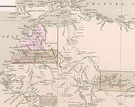 1886 map showing the small part of the Northern Territory subdivided into five counties | |
|
County of Gladstone | |
| Coordinates | 15°0′0″S 135°0′0″E / 15.00000°S 135.00000°ECoordinates: 15°0′0″S 135°0′0″E / 15.00000°S 135.00000°E[1] |
| Established | 9 January 1873[2] |
County of Gladstone is one of the five counties in the Northern Territory which are part of the cadastral divisions of Australia.
Gladstone County was one of the original three counties in the top end, and the only County not in the Darwin hinterland. The county was partly subdivided into parish or Hundreds.
The county was centred on the Roper River at a time when the Roper River seemed to offer a great economic possibility. The county covers the traditional lands of the Ngalakan, Marra, and Mangarayi peoples. Today it lies within Roper Gulf Shire Council and the main settlements in the County include Urapunga, Mataranka and Jilkminggan, Ngukurr and Elsey, Northern Territory. Geographic features include Elsey and Limmen National Park.
Name
Like the other Counties of the Northern Territory, Gladstone is named for a British Prime Minister, in this case the County was named after William Ewart Gladstone. Most of the Hundreds in the County are named after people and places associated with Gladstone.
Hundreds
The central part of the County was originally subdivided into Hundreds, but these have largely become redundant.
References
- ↑ "Map of Northern Territory / John Sands". National Library of Australia. John Sands (Firm). 1886. Retrieved 24 September 2018.
- ↑ Ayers, Henry (9 January 1873). "Proclamation, Counties of Gladstone and Disraeli" (PDF). South Australian Government Gazette. South Australian Government. p. 28. Retrieved 24 September 2018.