Huairou District
| Huairou 怀柔区 | |
|---|---|
| District | |
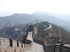 Mutianyu Great Wall | |
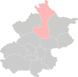 Location of Huairou District in Beijing | |
| Coordinates: 40°18′53.928″N 116°37′33.24″E / 40.31498000°N 116.6259000°E | |
| Country | People's Republic of China |
| Municipality | Beijing |
| Township-level divisions |
2 subdistricts 12 towns 2 ethnic townships |
| Area | |
| • Total | 2,557.3 km2 (987.4 sq mi) |
| Population (2000) | |
| • Total | 296,002 |
| • Density | 120/km2 (300/sq mi) |
| Time zone | UTC+8 (China Standard) |
| Area code(s) | 0010 |
| Website |
www |
Huairou District (simplified Chinese: 怀柔区; traditional Chinese: 懷柔區; pinyin: Huáiróu Qū) is situated in northern Beijing about 50 kilometers from the city center (about a 1½ to 2 hour drive).
History
In 1995 during the United Nation's 4th World's Women Conference in Beijing, the Civil Society community was forced to meet in the Huairou district, an hour from the official proceedings, leading to a great deal of discontent, as many of the non-governmental actors present felt marginalized. In a tent at the Civil Society Village established especially for poor, grassroots women at the conference (organized by GROOTS International), the Huairou Commission, a registered non-governmental organization with a global secretariat in Brooklyn, NY, was established to ensure that grassroots women would have a voice at subsequent UN conferences and in other development processes.[1]
Geography
Huairou District, covering an area of 2,557.3 square kilometres (987.4 sq mi). 90 percent of it is mountainous area. Because of its 69% forest cover, the district is known as the natural "oxygen bar" of Beijing. In addition, it boasts a rich combination of plant, animal and tourism resources. Therefore, Huairou is of great importance to Beijing in ensuring the environmental quality and the ecosystem of the capital city.
Administrative divisions
There are 2 subdistricts, 12 towns with 3 towns of which carry the "area" (地区) label, and 2 ethnic townships in the district:.[lower-alpha 1][2] Huairou's urban area (112,662 in township) has an estimated area of 11.5 km2 (4.4 sq mi) and an estimated population of 90,000.[3]
| Name | Chinese (S) | Hanyu Pinyin | Population (2010)[4] | Area (km2) |
|---|---|---|---|---|
| Longshan Subdistrict | 龙山街道 | Lóngshān Jiēdào | 44,203 | 7.50 |
| Quanhe Subdistrict | 泉河街道 | Quánhé Jiēdào | 54,471 | 5.10 |
| Huairou (town) Area | 怀柔(镇)地区 | Huáiróu (Zhèn) Dìqū | 66,485 | 69.00 |
| Yanqi (town) Area | 雁栖(镇)地区 | Yànqī (Zhèn) Dìqū | 25,933 | 154.08 |
| Miaocheng (town) Area | 庙城(镇)地区 | Miàochéng (Zhèn) Dìqū | 34,027 | 32.70 |
| Beifang town | 北房镇 | Běifáng Zhèn | 24,541 | 42.10 |
| Yangsong town | 杨宋镇 | Yángsòng Zhèn | 24,642 | 30.50 |
| Qiaozi town | 桥梓镇 | Qiáozǐ Zhèn | 21,914 | 112.62 |
| Huaibei town | 怀北镇 | Huáiběi Zhèn | 12,475 | 104.72 |
| Tanghekou town | 汤河口镇 | Tānghékǒu Zhèn | 6,372 | 225.09 |
| Bohai town | 渤海镇 | Bóhǎi Zhèn | 14,016 | 192.02 |
| Jiuduhe town | 九渡河镇 | Jiǔdùhé Zhèn | 15,206 | 177.40 |
| Liulimiao town | 琉璃庙镇 | Liúlímiào Zhèn | 5,938 | 226.30 |
| Baoshan town | 宝山镇 | Bǎoshān Zhèn | 8,244 | 250.45 |
| Changxiaoying Manchu Ethnic Township | 长哨营满族乡 | Zhǎngshàoyíng Mǎnzú Xiāng | 6,570 | 249.43 |
| Labagoumen Manchu Ethnic Township | 喇叭沟门满族乡 | Lǎbāgōumén Mǎnzú Xiāng | 4,895 | 302.00 |
Economy
Its major agricultural products are chestnuts, walnuts, hawthorns, sweet pears, and apricots.
Tourism
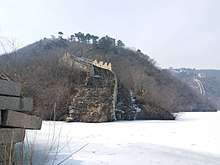
The Great Wall of China runs through the district and some of the choicest tourist sections are located in the district.[5] The portion known as Mutianyu is one of the most popular sections of the Great Wall for tourists.[5] The Lakeside Great Wall in Huanghuacheng village, Jiuduhe is another tourist section known for the proximity of the Great Wall to man-made reservoir and even parts of the Great Wall are submerged under the lake water.[5]
Another tourist attraction is Hong Luo Mountain on which the Hong Luo Temple is located.
Gallery
 Huairou No.1 Middle School
Notes
- ↑ These towns are officially classified as subdistricts, but as they coincide with the area of the same name, they are commonly named "areas" (地区)
References
- ↑ Huairou Commission website
- ↑ 2011年统计用区划代码和城乡划分代码:怀柔区 (in Chinese). National Bureau of Statistics of the People's Republic of China. Retrieved 2013-08-07.
- ↑ China (CN) Beijing Metropolitan Province
- ↑ shi, Guo wu yuan ren kou pu cha ban gong; council, Guo jia tong ji ju ren kou he jiu ye tong ji si bian = Tabulation on the 2010 population census of the people's republic of China by township / compiled by Population census office under the state; population, Department of; statistics, employment statistics national bureau of (2012). Zhongguo 2010 nian ren kou pu cha fen xiang, zhen, jie dao zi liao (Di 1 ban. ed.). Beijing Shi: Zhongguo tong ji chu ban she. ISBN 978-7-5037-6660-2.
- 1 2 3 "Beijing Bucket List: Huanghuacheng Lakeside Great Wall". The Beijing. January 29, 2017.
External links
| Wikivoyage has a travel guide for Huairou. |
![]()
- Official website of Huairou District
- Official website of Huairou District (in simplified Chinese)
| Administration |
|  | ||||||
|---|---|---|---|---|---|---|---|---|
| Education | ||||||||
| Transportation |
| |||||||
| Visitor attractions |
| |||||||
| Municipal agencies |
| |||||||
| ||||||||