Hosadurga
| Hosadurga | |
|---|---|
| Town | |
 Hosadurga Located in Karnataka, India | |
| Coordinates: 13°48′N 76°17′E / 13.8°N 76.29°ECoordinates: 13°48′N 76°17′E / 13.8°N 76.29°E | |
| Country |
|
| State |
|
| District | Chitradurga |
| Elevation | 739 m (2,425 ft) |
| Population (2011) | |
| • Total | 28,370 |
| Languages | |
| • Official | Kannada |
| Time zone | UTC+5:30 (IST) |
| PIN | 577527 [1] |
| Telephone code | +91-8199 [2] |
| Vehicle registration | KA 16 |
| Website |
www |
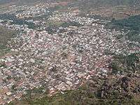
Hosadurga is a town in the Chitradurga district in the Indian state of Karnataka. It is the Taluk centre of the tehsil with the same name.
Geography
Hosadurga is located in Karnataka, India,[3] with an average elevation of 739 meters (2424 feet) above sea level.
Demographics
As of the 2011 India census,[4] Hosadurga has a population of 28,370. Males constitute 52% of the population and females 48%. Hosadurga has an average literacy rate of 72%, higher than the national average of 59.5%, with a male literacy rate of 76% and a female literacy rate of 70%. In Hosadurga, 12% of the population is under seven years of age.
Minerals
Hosadurga had a strong cement industry in the 1990s, but many factories have closed over time due to shortages of limestone. Currently only one remains, the Ramco Cement Factory in Mathodu Village.[5]
See also
References
| Wikimedia Commons has media related to Hosadurga. |
- ↑ Hosadurga Pin Code, Postal Code, Zip Code, Map | Ramanagar Pin Code
- ↑ STD Codes India, Hosadurga
- ↑ Falling Rain Genomics, Inc - Hosadurga
- ↑ "Census of India 2001: Data from the 2001 Census, including cities, villages and towns (Provisional)". Census Commission of India. Archived from the original on 2004-06-16. Retrieved 2008-11-01.
- ↑ "Strategically Located to Feed Growing Markets". Archived from the original on 4 February 2013. Retrieved 22 September 2012.