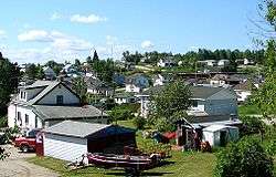
Hornepayne
| Hornepayne | ||
|---|---|---|
| Township (single-tier) | ||
| Township of Hornepayne | ||
 | ||
| ||
 Hornepayne | ||
| Coordinates: 49°13′N 84°47′W / 49.217°N 84.783°WCoordinates: 49°13′N 84°47′W / 49.217°N 84.783°W | ||
| Country |
| |
| Province |
| |
| District | Algoma | |
| Established | 1915 | |
| Incorporated | 1927 | |
| Government | ||
| • Type | Township | |
| • Mayor | Morley Forster | |
| • Federal riding | Algoma—Manitoulin—Kapuskasing | |
| • Prov. riding | Algoma—Manitoulin | |
| Area[1] | ||
| • Land | 204.52 km2 (78.97 sq mi) | |
| Population (2016)[1] | ||
| • Total | 980 | |
| • Density | 4.8/km2 (12/sq mi) | |
| Time zone | UTC-5 (EST) | |
| • Summer (DST) | UTC-4 (EDT) | |
| Postal Code | P0M | |
| Area code(s) | 807 | |
| Website | www.townshipofhornepayne.ca | |
Hornepayne is a township of 980 people (Canada 2016 Census) located in the Algoma District of Ontario, Canada. The town was originally established in 1915 as Fitzback when the Canadian Northern Railway's transcontinental line was built through the area. It was renamed Hornepayne in 1920 after British financier Robert Horne-Payne.[2][3]
Demographics
| Canada census – Hornepayne community profile | |||
|---|---|---|---|
| 2016 | 2011 | 2006 | |
| Population: | 980 (-6.7% from 2011) | 1,050 (-13.2% from 2006) | 1,209 (-11.2% from 2001) |
| Land area: | 204.07 km2 (78.79 sq mi) | 204.52 km2 (78.97 sq mi) | 204.52 km2 (78.97 sq mi) |
| Population density: | 4.8/km2 (12/sq mi) | 5.1/km2 (13/sq mi) | 5.9/km2 (15/sq mi) |
| Median age: | 42.9 (M: 43.1, F: 42.4) | 41.2 (M: 41.0, F: 41.5) | 38.6 (M: 39.5, F: 38.1) |
| Total private dwellings: | 514 | 518 | 539 |
| Median household income: | $99,584 | $68,217 | |
| References: 2016[4] 2011[5] 2006[6] earlier[7] | |||
Population:[8]
- Population in 2011: 1,050
- Population in 2006: 1,209
- Population in 2001: 1,362
- Population in 1996: 1,480
- Population in 1991: 1,610
Mother tongue:[9]* English as first language: 78.3%
- French as first language: 16.3%
- English and French as first language: 0%
- Other as first language: 5.4%
Economy
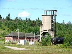
Hornepayne serves as a railway divisional point on the main Canadian National Railway line. The forestry industry (by way of Haavaldsrud's Timber Company[10]) is the major employer to the local economy. Hunting and fishing related tourism in the area (particularly just north of the town in nearby Nagagami Lake Provincial Park) is served by several small companies.[11][12][13]
The township of Hornepayne has been the proposed site of a low level nuclear waste storage facility for some time. The town's community liaison group chose to withdraw from this development in the early 1990s,[14] but as of May 2010 the township is still being considered for nuclear waste management/storage.[15]
Transportation
Hornepayne was served by the Hornepayne Municipal Airport and the Hornepayne railway station which is a stop for Via Rail's transcontinental train The Canadian.
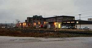
 The CN rail yard; the old station in the background is no longer in use and fallen in disrepair. |
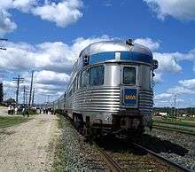 Passengers milling around the train at the station stop in Hornepayne. |
Popular culture
- Retired ice hockey player Mike McEwen was born in Hornepayne.
- Retired ice hockey player Goldie Goldthorpe (who served as the inspiration for Ogie Ogilthorpe in the 1977 film Slap Shot) was born in Hornepayne.
- Senior Vice President of Hockey Operations for NHL Kris King, was raised in Hornepayne.
- Gordon Lightfoot's song "On the High Seas" mentions Hornepayne with the following lyric "Was it up in Hornepayne, where the trains run on time?"
- Hornepayne was featured on an episode of Survivorman with Les Stroud and a slew of NHL hockey players.
Climate
| Climate data for Hornepayne, Ontario (1971–2000) | |||||||||||||
|---|---|---|---|---|---|---|---|---|---|---|---|---|---|
| Month | Jan | Feb | Mar | Apr | May | Jun | Jul | Aug | Sep | Oct | Nov | Dec | Year |
| Record high °C (°F) | 6.7 (44.1) |
12.8 (55) |
18.9 (66) |
28.9 (84) |
33.0 (91.4) |
37.2 (99) |
37.2 (99) |
34.4 (93.9) |
31.7 (89.1) |
31.7 (89.1) |
18.0 (64.4) |
12.5 (54.5) |
37.2 (99) |
| Average high °C (°F) | −13.1 (8.4) |
−9.2 (15.4) |
−2.6 (27.3) |
6.9 (44.4) |
16.4 (61.5) |
21.0 (69.8) |
24.1 (75.4) |
22.0 (71.6) |
15.3 (59.5) |
8.6 (47.5) |
0.5 (32.9) |
−8.8 (16.2) |
6.8 (44.2) |
| Daily mean °C (°F) | −19.7 (−3.5) |
−16 (3) |
−9.2 (15.4) |
0.4 (32.7) |
8.9 (48) |
13.4 (56.1) |
16.4 (61.5) |
14.2 (57.6) |
8.8 (47.8) |
3.5 (38.3) |
−3.8 (25.2) |
−14.5 (5.9) |
0.2 (32.4) |
| Average low °C (°F) | −26.1 (−15) |
−22.7 (−8.9) |
−15.7 (3.7) |
−6.1 (21) |
1.5 (34.7) |
5.7 (42.3) |
8.6 (47.5) |
8.5 (47.3) |
2.2 (36) |
−1.6 (29.1) |
−8.1 (17.4) |
−20.3 (−4.5) |
−6.3 (20.7) |
| Record low °C (°F) | −49.4 (−56.9) |
−52.2 (−62) |
−43.9 (−47) |
−37.2 (−35) |
−15 (5) |
−12.2 (10) |
−9.4 (15.1) |
−7.2 (19) |
−12.2 (10) |
−27.2 (−17) |
−40 (−40) |
−52.2 (−62) |
−52.2 (−62) |
| Average precipitation mm (inches) | 53.4 (2.102) |
38.5 (1.516) |
38.9 (1.531) |
28.7 (1.13) |
51.4 (2.024) |
81.5 (3.209) |
65.4 (2.575) |
67.2 (2.646) |
70.3 (2.768) |
60.8 (2.394) |
49.3 (1.941) |
51.0 (2.008) |
656.4 (25.843) |
| Average rainfall mm (inches) | 0.1 (0.004) |
1.6 (0.063) |
3.9 (0.154) |
11.1 (0.437) |
45.3 (1.783) |
81.5 (3.209) |
65.4 (2.575) |
67.2 (2.646) |
69.4 (2.732) |
48.9 (1.925) |
15.1 (0.594) |
0.9 (0.035) |
410.5 (16.161) |
| Average snowfall cm (inches) | 53.3 (20.98) |
36.9 (14.53) |
35.0 (13.78) |
17.6 (6.93) |
6.1 (2.4) |
0.0 (0) |
0.0 (0) |
0.0 (0) |
0.9 (0.35) |
12.6 (4.96) |
34.3 (13.5) |
50.1 (19.72) |
246.7 (97.13) |
| Average precipitation days (≥ 0.2 mm) | 8.6 | 6.8 | 7.3 | 5.9 | 7.3 | 9.2 | 8.6 | 9.4 | 12.9 | 10.9 | 9.2 | 9.4 | 105.5 |
| Average rainy days (≥ 0.2 mm) | 0.12 | 0.38 | 1.1 | 2.8 | 6.5 | 9.2 | 8.6 | 9.4 | 12.8 | 8.6 | 2.6 | 0.41 | 62.5 |
| Average snowy days (≥ 0.2 cm) | 8.5 | 6.7 | 6.4 | 3.6 | 1.0 | 0.0 | 0.0 | 0.0 | 0.22 | 2.9 | 7.1 | 9.3 | 45.7 |
| Source: Environment Canada[16] | |||||||||||||
See also
References
- 1 2 "Hornepayne census profile". 2016 Census of Population. Statistics Canada. Retrieved 2018-04-13.
- ↑ Roy, Patricia. "Robert Montgomery Horne-Payne". The Canadian Encyclopedia. Retrieved 3 October 2016.
- ↑ Douglas, Daniel (1995). Northern Algoma : a people's history. Toronto: Dundurn Press. p. 87. ISBN 9781550022353.
- ↑ "2016 Community Profiles". Canada 2016 Census. Statistics Canada. February 21, 2017. Retrieved 2017-04-13.
- ↑ "2011 Community Profiles". Canada 2011 Census. Statistics Canada. July 5, 2013. Retrieved 2012-02-16.
- ↑ "2006 Community Profiles". Canada 2006 Census. Statistics Canada. March 30, 2011. Retrieved 2012-02-16.
- ↑ "2001 Community Profiles". Canada 2001 Census. Statistics Canada. February 17, 2012.
- ↑ Statistics Canada: 1996, 2001, 2006, 2011 census
- ↑ Statistics Canada 2006 Census
- ↑ http://www.haavaldsrud.com/home.shtml
- ↑ http://www.noto.net/regional.cfm/code/85/tbid/7
- ↑ http://www.pronorthoutfitters.com/
- ↑ http://flyinfishingcamps.com/
- ↑ http://deepblue.lib.umich.edu/bitstream/2027.42/73397/1/j.1754-7121.1994.tb00885.x.pdf
- ↑ http://www.nwmo.ca/uploads_managed/MediaFiles/1797_hornepayne-summaryreport.pdf
- ↑ "Hornepayne, Ontario". Canadian Climate Normals 1971–2000. Environment Canada. Retrieved 24 April 2015.
External links
| Wikimedia Commons has media related to Hornepayne, Ontario. |
Places adjacent to Hornepayne | |
|---|---|
