Mississauga First Nation
| Mississagi River 8 Misswezahging | ||
|---|---|---|
| Indian reserve | ||
| Mississagi River Indian Reserve No. 8 | ||
 | ||
| ||
 Mississagi River 8 | ||
| Coordinates: 46°13′N 83°00′W / 46.217°N 83.000°WCoordinates: 46°13′N 83°00′W / 46.217°N 83.000°W | ||
| Country |
| |
| Province |
| |
| District | Algoma | |
| First Nation | Mississauga | |
| Area[1] | ||
| • Land | 18.41 km2 (7.11 sq mi) | |
| Population (2011)[1] | ||
| • Total | 390 | |
| • Density | 21.2/km2 (55/sq mi) | |
| Time zone | UTC-5 (EST) | |
| • Summer (DST) | UTC-4 (EDT) | |
| Website | www.mississaugi.com | |
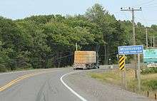
The sign for the Mississauga First Nation on Ontario Highway 17
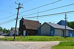
Mississauga First Nation is one of the six First Nations that make up the Mississauga Nations. It is located directly west of Blind River, Ontario, Canada, on the Mississagi River 8 Reserve.[2]
Name
The word Mississauga is an anglicized version of the Ojibwe word Misswezahging, which means ‘a river with many outlets.’ This name comes from the Mississaugi River, which is a bird-foot delta, a haven for fish and waterfowl and is currently a jointly managed Provincial Park.
References
- 1 2 "Mississagi River 8 census profile". 2011 Census of Population. Statistics Canada. Retrieved 3 June 2015.
- ↑ "Mississisauga 8", First Nation, Canada Archived July 22, 2010, at the Wayback Machine.
External links
- The Smoke Signal, Mississaugi First Nation News
- "Mississisauga", Indian and Northern Affairs Canada
Places adjacent to Mississauga First Nation | ||||||||||
|---|---|---|---|---|---|---|---|---|---|---|
| ||||||||||
Mississauga First Nation Logo
| Robinson Superior Treaty, 1850 | |
|---|---|
| Robinson Huron Treaty, 1850 | |
| Saugeen Surrenders, 1854 | |
| Pennefather Treaty, 1859 | |
| Non-signatories | |
| |

This article is issued from
Wikipedia.
The text is licensed under Creative Commons - Attribution - Sharealike.
Additional terms may apply for the media files.