Horní Město
| Horní Město | |||
|---|---|---|---|
| Municipality and village | |||
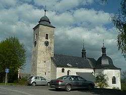 Church of Saint Mary Magdalene | |||
| |||
 Horní Město Location in the Czech Republic | |||
| Coordinates: 49°55′N 17°13′E / 49.917°N 17.217°ECoordinates: 49°55′N 17°13′E / 49.917°N 17.217°E | |||
| Country |
| ||
| Region | Moravian-Silesian Region | ||
| District | Bruntál District | ||
| Government | |||
| • Mayor | Eva Machová | ||
| Area | |||
| • Total | 12.21 sq mi (31.62 km2) | ||
| Elevation | 1,800 ft (550 m) | ||
| Population (2011) | |||
| • Total | 968 | ||
| • Density | 79/sq mi (31/km2) | ||
| Time zone | UTC+1 (CET) | ||
| • Summer (DST) | UTC+2 (CEST) | ||
| Zip code | 793 44 | ||

Horní Město (German: Bergstadt) is a town with 1009 inhabitants (as of 1 January 2004) in Bruntál District in the Moravian-Silesian Region of the Czech Republic. It is located in the headwaters of the river Huntava 5 kilometres (3.1 mi) southwest of Rýmařov at the foot of the Jeseníky mountains. From 1938 to 1945 it was one of the municipalities in Sudetenland.
History
The town was founded as a German-speaking mining town near a rich silver mining site in 1351. In 1398, a neighboring settlement emerged near a cache of slope stone. In 1580 the city was awarded an imperial free city status by the emperor, Rudolf II. On 1 December 1930, the town had 1,296 inhabitants; on 17 May 1939 there were 1251; and on 22 May 1947 674 inhabitants. The Germans were expropriated in 1945 and their lands sold.
Attractions
The Church of St. Mary Magdalene was built in 1611 and re-designed in 1690 by the painter Weintritt who added valuable paintings.
Community Structure
The Horní Město area include districts Dobřečov (Doberseik), Rešov (Reschen), Skály (Hangenstein), and Stříbrné Hory (Neufang) with the 1965 settlement, Ferdinandov (Ferdinandsthal).
Sons and Daughters of the Community
- Karl Brachtel (1825-1895), painter and restorer
External links
- http://www.hornimesto.cz/ (in Czech)
- https://web.archive.org/web/20050221080731/http://www.rymarovsko.cz/hornimesto/ (in Czech)
| Wikimedia Commons has media related to Horní Město. |