Dětřichov nad Bystřicí
| Dětřichov nad Bystřicí Dittersdorf an der Feistritz | ||
|---|---|---|
| Municipality and village | ||
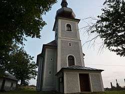 Saint George Church | ||
| ||
 Dětřichov nad Bystřicí Location in the Czech Republic | ||
| Coordinates: 49°51′N 17°25′E / 49.850°N 17.417°ECoordinates: 49°51′N 17°25′E / 49.850°N 17.417°E | ||
| Country |
| |
| Region | Moravian-Silesian Region | |
| District | Bruntál District | |
| Area | ||
| • Total | 10.9 sq mi (28.3 km2) | |
| Elevation | 1,995 ft (608 m) | |
| Population (2014) | ||
| • Total | 441 | |
| • Density | 40/sq mi (16/km2) | |
| Time zone | UTC+1 (CET) | |
| • Summer (DST) | UTC+2 (CEST) | |
Dětřichov nad Bystřicí (German: Dittersdorf) is a village and municipality in Bruntál District in the Moravian-Silesian Region of the Czech Republic. The municipality covers an area of 2,831 hectares (7,000 acres) and as of 2014 it had a population of 441.
History
Until 1918, DITTERSDORF was part of the Austrian monarchy (Austria side after the compromise of 1867), in the Sternberg (Šternberk) district, one of the 34 Bezirkshauptmannschaften in Moravia.[1]
A post-office was opened in 1873.
In 1938, after the Munich Agreement, it was occupied by the Nazi army as one of the municipalities in Sudetenland (Landkreis Sternberg (Mähren)).[2] The German speaking population was expelled in 1945 (further to the Beneš decrees) and replaced by Czech settlers.
References
| Wikimedia Commons has media related to Dětřichov nad Bystřicí. |
This article is issued from
Wikipedia.
The text is licensed under Creative Commons - Attribution - Sharealike.
Additional terms may apply for the media files.