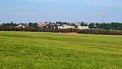
Hora Svatého Šebestiána
| Hora Svatého Šebestiána | |||
|---|---|---|---|
| Municipality | |||
 Hora Svatého Šebestiána | |||
| |||
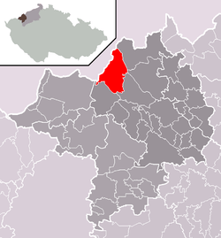 Location in Chomutov District | |||
 Hora Svatého Šebestiána Location in the Czech Republic | |||
| Coordinates: 50°31′40″N 13°14′9″E / 50.52778°N 13.23583°ECoordinates: 50°31′40″N 13°14′9″E / 50.52778°N 13.23583°E | |||
| Country |
| ||
| Region | Ústí nad Labem | ||
| District | Chomutov | ||
| Area | |||
| • Total | 34.4 km2 (13.3 sq mi) | ||
| Elevation | 843 m (2,766 ft) | ||
| Population (2006) | |||
| • Total | 276 | ||
| • Density | 8.0/km2 (21/sq mi) | ||
| Postal code | 430 01 to 431 82 | ||
| Website | http://www.sebestian.cz | ||


Hora Svatého Šebestiána (German: Sankt Sebastiansberg) is a village and municipality (obec) in Chomutov District in the Ústí nad Labem Region of the Czech Republic.
The municipality covers an area of 34.4 square kilometres (13.3 sq mi), and has a population of 276 (as at 28 August 2006).
Hora Svatého Šebestiána lies approximately 14 kilometres (9 mi) north-west of Chomutov, 59 km (37 mi) west of Ústí nad Labem, and 98 km (61 mi) north-west of Prague.
References
| Wikimedia Commons has media related to Hora Svatého Šebestiána. |
This article is issued from
Wikipedia.
The text is licensed under Creative Commons - Attribution - Sharealike.
Additional terms may apply for the media files.