Blatno (Chomutov District)
| Blatno | |||
|---|---|---|---|
| Municipality | |||
%2C_north_part.jpg) | |||
| |||
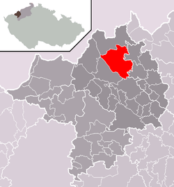 Location of Blatno within Chomutov District | |||
 Blatno Location of Blatno within Czech Republic | |||
| Coordinates: 50°30′43″N 13°21′16″E / 50.51194°N 13.35444°ECoordinates: 50°30′43″N 13°21′16″E / 50.51194°N 13.35444°E | |||
| Country |
| ||
| Region | Ústí nad Labem | ||
| District | Chomutov | ||
| Area | |||
| • Total | 45.34 km2 (17.51 sq mi) | ||
| Elevation | 660 m (2,170 ft) | ||
| Population (2006) | |||
| • Total | 388 | ||
| • Density | 8.6/km2 (22/sq mi) | ||
| Postal code | 430 01 | ||
| Website | http://www.obec-blatno.cz | ||
Blatno (German: Platten) is a village and municipality (obec) in Chomutov District in the Ústí nad Labem Region of the Czech Republic.
The municipality covers an area of 45.34 square kilometres (17.51 sq mi), and has a population of 388 (as at 28 August 2006).
Blatno lies approximately 6 kilometres (4 mi) north-west of Chomutov, 52 km (32 mi) west of Ústí nad Labem, and 90 km (56 mi) north-west of Prague.
Gallery
 Blatno Castle, now municipal office
%2C_memorial.jpg) World War I memorial
World War I memorial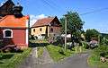 Local part Hrádečná
References
| Wikimedia Commons has media related to Blatno (Chomutov District). |
This article is issued from
Wikipedia.
The text is licensed under Creative Commons - Attribution - Sharealike.
Additional terms may apply for the media files.