Honoraville, Alabama
| Honoraville, Alabama | |
|---|---|
| Unincorporated community | |
 Honoraville, Alabama  Honoraville, Alabama | |
| Coordinates: 31°51′03″N 86°24′22″W / 31.85083°N 86.40611°WCoordinates: 31°51′03″N 86°24′22″W / 31.85083°N 86.40611°W | |
| Country | United States |
| State | Alabama |
| County | Crenshaw |
| Elevation | 512 ft (156 m) |
| Time zone | UTC-6 (Central (CST)) |
| • Summer (DST) | UTC-5 (CDT) |
| ZIP code | 36042 |
| Area code(s) | 334 |
| GNIS feature ID | 155105[1] |
Honoraville is an unincorporated community in Crenshaw County, Alabama, United States, located 12.5 miles (20.1 km) northwest of Luverne. Honoraville has a post office with ZIP code 36042.[2][3]
References
- ↑ "Honoraville". Geographic Names Information System. United States Geological Survey.
- ↑ United States Postal Service (2012). "USPS - Look Up a ZIP Code". Retrieved 2012-02-15.
- ↑ "Postmaster Finder - Post Offices by ZIP Code". United States Postal Service. Retrieved June 5, 2013.
Municipalities and communities of Crenshaw County, Alabama, United States | ||
|---|---|---|
| Cities | 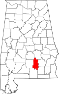 | |
| Towns | ||
| Unincorporated communities | ||
| Footnotes | ‡This populated place also has portions in an adjacent county or counties | |
This article is issued from
Wikipedia.
The text is licensed under Creative Commons - Attribution - Sharealike.
Additional terms may apply for the media files.