Hong Kong tropical cyclone warning signals
The Hong Kong tropical cyclone warning signals (Chinese: 熱帶氣旋警告信號), or informally typhoon signals (Chinese: 風球; Sidney Lau: fung1 kau4, literally, "wind balls"), are a set of signals used to indicate the threat or effects of a tropical cyclone. The Hong Kong Observatory issues the warning signal if a tropical cyclone approaches within 800 kilometres (500 mi) of Hong Kong and poses a threat of deteriorating conditions in Hong Kong.
The signals are represented as a set of numbers and symbols. Previously lights were also used at night.
History
The Hong Kong Observatory began issuing warnings for tropical cyclones in 1884, when it began to monitor and report news of tropical cyclones within the South China Sea, and the areas around Guam and Manila. The monitoring efforts later expanded to gathering information from various seafaring vessels. These works were done in conjunction with the Marine Department until 1886. At first, the monitoring and warning services were geared mainly towards seafarers, and not towards the residents of Hong Kong.[1]
The warning system was numerical, consisting of symbols hoisted at various places in Victoria Harbour, in the form of drums, balls, and cones. At first, the signals only gave information as to the cardinal direction from which winds were coming. Revisions of the system in 1904 added alerts as to ordinal wind direction. Until 1917, there were two sets of warning signals, one set with black symbols, and one with red. The black symbols indicated that the tropical cyclone in question was less than 300 miles (480 km) from Hong Kong, while the red symbols indicated a distance of over 300 miles (480 km).[1]
The alert system was also supplemented by the firing of guns (later cannons and bombs which, being so much louder, were considered an improvement), which became relied upon for severe weather updates, as few residents paid attention to the visual warning system intended for seafarers. Intensity was indicated by number of shots, three being an indication of a very intense cyclone. This audible alert system ended in 1937, as residents began to rely on radio, newspapers, and notices at ferry piers for tropical cyclone information.[1]
After a failed attempt at consensus with Japan over warning standards in 1917, the Observatory replaced its system with a seven-level system (four of which were ultimately converted into the four no. 8 signals used today). Attempts to convince other jurisdictions around the South China Sea to adopt this system likewise failed. It was repurposed for domestic use and, at the request of Hong Kong's Chamber of Commerce, another set of warning signals for tropical cyclones outside of Hong Kong was used concurrently by the Hong Kong Observatory until 1962.[1]
Eventually, over the years, the storm signals deviated from their original purpose of serving mariners, and became a system for the domestic population.[1] In 1931, the system was amended to 1 to 10 with three new signals added, which are signals 2 and 3 signifying strong winds from southwest and southeast respectively, and signal 4, a non-local signal meaning that a dangerous typhoon exists but poses no imminent danger to locality. The four gale signals, renumbered 5 to 8, also had their directions changed to the current four quadrants, while the original signals 6 and 7 were renumbered 9 and 10. Signals 2, 3 and 4 were discontinued in the late 1930s, and the no. 3 strong wind signal was introduced in 1956. From 1 January 1973, signals 5 to 8 were replaced by 8 NW, 8 SW, 8 NE and 8 SE, respectively, so as to improve comprehensibility to the public. What had started out as a 10-level warning system had been reduced to the five-level (1,3,8,9,10) system that has been in use ever since.[2]
In the 1960s, there were 42 signal stations around the territory.
HONG KONG ISLAND: Lye Yue Mun Fort, Shau Kei Wan Marine Licensing Office, North Point Ferry Pier*, H.M.S. Tamar, Marine Department Headquarters, Green Island, Aberdeen Police Station, Stanley Village Police Station and Stanley Fort.
KOWLOON: Kwun Tong Shell Oil Company Installation, Kowloon Docks*, Blackhead Hill, Kowloon Railway Station*, Royal Observatory, Kowloon Hospital, Kowloon Wharf & Godown Co^, Yau Ma Tei Marine Licensing Office and Stonecutters Island*.
NEW TERRITORIES EAST: Rennies' Mill Police Station, Sha Tin Police Station, Sai Kung Police Station, Tai Po Kau Marine Police Operations Base, Tai Po District Office, Tai Mei Tuk Police Post and Sha Tau Kok Medical Department Clinic.
NEW TERRITORIES WEST: Tsuen Wan Caltex Oil Company Depot, Sham Tseng San Miguel Brewery*, Tai Lam Chung Marine Police Operations Base, Castle Peak Police Station, Ping Shan Police Station, Lau Fau Shan Police Station, Yuen Long Divisional Police Headquarters, Pat Heung Police Station and Lok Ma Chau Police Station.
OUTLYING ISLANDS: Waglan Island, Cheung Chau Police Station, Peng Chau Police Station, Mui Wo Police Station, Shek Pik Police Post, Tai O Police Station and Lamma Police Post.
(^ = Day signals only displayed and * = Night signals only displayed)
The last, Cheung Chau aeronautical meteorological station on Cheung Chau, was decommissioned on 1 January 2002. Accordingly, the observatory has replaced the word hoist with issue in its official terminology, although the phrase "Signal No. __ has been hoisted" is still widely used by the public and the mass media. Weather authorities in Macao, however, still use the term "hoisted" when issuing their tropical cyclone warnings, the system of which is based heavily upon Hong Kong's.
Current system

In accordance with legal codes and custom in Hong Kong, once any signal higher than No. 3 is issued, all government agencies shut down their operations, schools immediately cease classes, financial markets and most of the private sector close their doors. Non-essential workers are released from work in a staggered manner so as to avoid overwhelming public transportation. Public transit agencies that operate on the sea or on surface streets and highways generally continue to operate initially but may cease operation at short notice. Employers who require staff to remain on duty during a No. 8 or higher signal must provide a safe work environment and shelter after work should transportation be unavailable. Such arrangements must be worked out beforehand between the employer and employee.[3] In order to minimise disruption, the Hong Kong Observatory has, since 1987, observed a practice of issuing warnings two hours in advance of the issuance of the No. 8 warning signal, though such warnings of warnings are not attended by any system of numbering such as to indicate the relative imminence of issuance of the typhoon warning signal itself.[4]
In its early days, as a system devised for the service of mariners, it relied upon wind speeds measured around Victoria Harbour. As the emphasis shifted to serving the intensively urbanised populace, such observations were seen as lacking relevance.[5] The Hong Kong Observatory was the target of criticism during Typhoon Prapiroon in 2006 when conditions in urban areas were much more severe than those on the harbour which had justified only a No. 3 signal being issued. In response, from 2007, the Hong Kong Observatory broadened its network to eight near sea-level reference anemometers around Hong Kong.[6]
When Typhoon Hato hit Hong Kong in August 2017 with signal 10 being issued, flights were suspended or cancelled, resuming as soon as it was safe, including throughout the night to make up for loss time. MTR cancelled train services in open sections of the line, and maintained a limited service underground on an adjusted schedule. All schools were closed for the day and the government opened temporary shelters. Trees fell and flooding occurred. The stock market (and other businesses) were suspended for part or a whole day.[7]
When Typhoon Mangkhut hit Hong Kong in September 2018 with signal 10 being issued, flights were suspended or cancelled, resuming as soon as it was safe, including throughout the night to make up for loss time. MTR cancelled train services in open sections of the line, and maintained a limited service underground on an adjusted schedule. All schools were closed for the day and the government opened temporary shelters. Trees fell and flooding occurred. The stock market (and other businesses) were suspended for part or a whole day. The windows had special masking tapes to keep the windows sticking but a lot of windows were still blown away.
Meaning of signals
The Saffir–Simpson hurricane wind scale is a classification used for some Western Hemisphere tropical cyclones. Hong Kong has a similar official five-level definition warning signals, which uses descriptions of winds taken from the Beaufort Scale, as shown in the table below. The Hong Kong levels, however do not correspond to the Beaufort Scale which has 12 levels.
The lowest level of the Hong Kong system No. 1 doesn't correspond to any wind strength. Instead it is an alert based on the distance of a storm.
The highest level, Hurricane Signal No. 10, is issued infrequently. There have been 16 No. 10 warnings since 1946, of which three have occurred in the 2010s thus far, for Typhoon Vicente in 2012, Typhoon Hato in 2017, and Typhoon Mangkhut in 2018.[8] No. 10 warnings generally occur in intervals of around four years or less, except for the period from the 1980s to 2000s when only two such signals were issued, for Typhoon Ellen in 1983 and Typhoon York in 1999.
Signals numbers will change in accordance with the conditions. The Hong Kong Observatory website gives live updates of issue and cancel times for signals.[9]
| Signal Number |
Signal Name |
Symbol | Meaning |
|---|---|---|---|
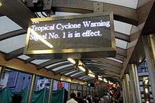
| 1 | Standby (戒備) |
 |
No. 1 signal is purely advisory. It is a standby signal and calls attention to the fact that there is a tropical cyclone centred within about 800 kilometres of Hong Kong which might later affect Hong Kong. If strong winds are not expected within 24 hours, the issuance of the signal may be delayed until the circulation moves closer or intensifies, but it should not be assumed that there will be a 24-hour interval between the issuance of No. 1 signal and the onset of strong winds.
When No. 1 signal is issued, staff required to take precautions during tropical cyclones should report to their offices and remain on call. Small crafts should remain within reach of shelter. Attention should be paid to weather bulletins as records show there are three chances in four that No. 1 signal will be followed by strong wind or gale warnings. Weather at this time is generally fine and hot. The No. 1 signal may also be issued when a tropical cyclone is departing Hong Kong but strong winds are still affecting offshore waters. |
| 3 | Strong Wind (強風) |
 |
No. 3 signal is a definite warning that a tropical cyclone is expected to come near enough to Hong Kong to cause strong winds in Hong Kong. Strong winds range from 41 to 62 kilometres per hour, but gusts may exceed 110 kilometres per hour. The warning refers to the general condition near sea level within Hong Kong, but winds on exposed hilltops and offshore waters may reach gale force.
No. 3 signal normally gives about 12 hours warning of strong winds generally over Hong Kong at sea level, but in exposed areas, winds may become strong sooner. Sailing craft, lighters and ships without power should be secured. Ships with power should move or prepare to move to typhoon buoys or anchorages. Contractors should see that all scaffolding, hoardings and other temporary structures are secured. Gutters and storm drains should be cleared of leaves and rubbish. Doors and windows should be checked to make sure that they can be securely fastened. Owners of small craft should complete arrangements for safety of their boats. Ferry services may soon be affected by wind or waves. Scheduled services to outlying districts may be cancelled in anticipation of worsening conditions. |
| 8NW | Gale or Storm (烈風或暴風) |
 |
No. 8 signals give warning of a gale or storm from one of the four quadrants. A gale ranges from 63 to 87 kilometres per hour and storm from 88 to 117 kilometres per hour. Gusts may exceed 180 kilometres per hour.
The timing of the issuance of the first of these signals is aimed to give about 12 hours warning of gales generally over Hong Kong near sea level, but the warning may be shorter for exposed areas and on high ground. Unexpected intensification of the tropical cyclone on accelerated movement closer to Hong Kong may reduce the warning period. When these signals are interchanged indicating an anticipated change in the direction of the gale or storm, the wind shift may be expected within a few hours. When one of these signals is issued, ferries generally stop running and all schools and law courts are closed. People away from home should either return immediately or find a safe place and remain there until the danger has passed. Windows and doors should be bolted and shuttered and cars parked in sheltered areas. Full typhoon precautions should be completed as soon as possible as it is extremely dangerous to delay these until No. 9 or No. 10 signal is issued. |
| 8SW |  | ||
| 8NE |  | ||
| 8SE |  | ||
| 9 | Increasing Gale or Storm (烈風或暴風風力增強) |
 |
No. 9 signal indicates that the gale or storm is expected to increase significantly in strength.
There are no firm rules as to when the signal may be issued, but the issuance usually implies that wind speeds are expected to reach the range 88 to 117 kilometres per hour, and that the centre of a typhoon will soon pass close to Hong Kong, with the consequent shifting of wind direction. All precautions should have been completed prior to the issuance of No. 9 signal. |
| 10 | Hurricane (颶風) |
 |
No. 10 signal gives warning of a hurricane force wind. Hurricane force winds range upwards from 118 kilometres per hour but gusts may exceed 220 kilometres per hour. This signal implies that a typhoon centre will soon pass over or very close to Hong Kong, and hurricane force winds can be expected anywhere near sea level in Hong Kong within a short time of the issuance of the signal.
It is advisable to stay indoors to avoid flying debris. If premises are buffeted by hurricane force winds, all internal doors should be kept tightly shut to lessen the chance of windows or air-conditioning units being blown out or sucked in. It may be useful to reinforce some windows with heavy furniture, props, bars or even mattresses. If people have to go out, they should keep clear of overhead wires and hoardings. Typhoons can cause the tide to rise much higher than normal. There storm surges may occur in enclosed inlets can cause serious flooding of low-lying land. Heavy rain may also cause flooding. Landslides may occur and some buildings may collapse. If you are advised to move to a safe place, it is essential to remain calm and co-operate with the rescue service. Should the eye of a typhoon pass over some part of Hong Kong, a lull may occur, lasting for a few minutes or even some hours. This will be followed by the return of hurricane force winds from a different direction. It is necessary to be prepared for the sudden change in wind direction because places that were well sheltered earlier may now become dangerously exposed. |
Hong Kong Observatory public guidance
The Hong Kong Observatory has given public guidance when signals are given.[10] This include:
When signal 1 is issued, to take into account in planning activities of a tropical cyclone and to be aware that strong winds may occur over offshore waters.
When signal 3 is issued, secure all loose objects, particularly on balconies and roof tops.
When signal 8 is issued, complete all precautions (such as secure all loose objects) before gales commence.
When signal 9 or 10 is issued, stay indoors and away from exposed windows and doors to avoid flying debris.
Macau counterpart
In Macau, the territory's Meteorological and Geophysical Bureau maintains a very similar system.[11] The bureau has maintained the practice of hoisting the warning signals (as well as its nighttime light signals), even as Hong Kong abandoned the practice in 2002. The signals are hoisted at Guia Fortress and the Fortaleza do Monte. In 2017, Typhoon Hato also reached Signal number 10, but Macau raised the signal too late, hours after Hong Kong.[12]
See also
References
- 1 2 3 4 5 "Modernisation of The City" (PDF) (in Chinese and English). Hong Kong Observatory. 2003. p. 68. Retrieved 24 August 2008.
- ↑ "History of the Hong Kong Tropical Cyclone Warning Signals". Hong Kong Observatory.
- ↑ "Code of Practice in times of Typhoons and Rainstorms" (PDF). Labour Department.
- ↑ "Related Advisory Information and Arrangements from Bureaux and Departments in Tropical Cyclone Situations". Hong Kong Observatory.
- ↑ "Regional Wind Information". Hong Kong Observatory.
- ↑ "Review of the Tropical Cyclone Warning System in 2006 and New Measures in 2007" (PDF). Hong Kong Observatory.
- ↑ https://www.bloomberg.com/news/articles/2017-08-22/hong-kong-braces-for-storm-hato-stock-trading-may-be-disrupted
- ↑ http://www.hko.gov.hk/cgi-bin/hko/warndb_e1.pl?opt=1&sgnl=10&start_ym=194609&end_ym=201208&submit=Submit+Query
- ↑ http://www.hko.gov.hk/wxinfo/dailywx/wxwarntoday.htm
- ↑ http://www.hko.gov.hk/publica/gen_pub/tcws.pdf
- ↑ "Meaning of Tropical Cyclone Signals and the relevant recommended safety precautions". Macao Meteorological and Geophysical Bureau. Retrieved 15 July 2013.
- ↑ Master, Tyrone Siu and Farah. "Weather boss steps down as Macau struggles to recover from typhoon". IN. Retrieved 2017-08-26.