Holuhraun
| Holuhraun | |
|---|---|
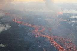 The Holuhraun lava field, on 4 September 2014, during the 2014 eruption | |
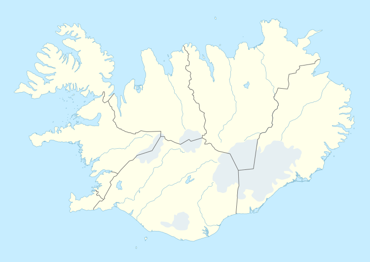 Map of Iceland showing the location of Holuhraun. | |
| Location | Suður-Þingeyjarsýsla, Northeastern Region, Iceland |
| Coordinates | 64°51′N 16°50′W / 64.85°N 16.83°WCoordinates: 64°51′N 16°50′W / 64.85°N 16.83°W |
| Geology | Lava field |
Holuhraun ([ˈhɔ:lur̥øin] (![]()
Geography
Holuhraun is situated at the southern end of Ódáðahraun, which is one of the largest lava fields in the country. The main volume of the Jökulsá á Fjöllum river flows from the eastern side of Holuhraun, in the Kverkfjöll area.[1] Hrimalda, Urðarháls and Kistufell are to the west of Holuhraun, with Dyngjuháls and Trölladyngja beyond.[3] The Dyngjujökull glacier, which is part of Vatnajökull, is to the immediate south.[1][3] Holuhraun is about 15 km (9.3 mi) south of the Askja caldera,[4] and the Bárðarbunga volcano is 41.39 km (25.7 mi) to the south-west[5] of Holuhraun. Holuhraun is traversed by an unnumbered road, which connects to the Route F910 gravel road at both the east and the west ends.[6][7]
Geology
Located at the northern and southern extensions of the Bárðarbunga and Askja fissure systems, respectively, the soil is mainly composed of lavas derived from these volcanoes, either in the form of flows or alluvial deposits of volcanic origin. The geological configuration, along with the presence of nearby subglacial volcanoes such as Bárðarbunga and Grímsvötn, is responsible for the risk of jökulhlaups, which have already affected Holuhraun, repeatedly.
Volcanism
%2C_13._September_2014.JPG)
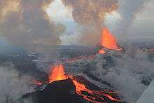
Until 2014, the surface of the lava field was of an older lava flow, which had erupted from a vent associated with Askja in 1797.[8][9] In the early hours of 29 August 2014, a small fissure eruption occurred in Holuhraun at the northern end of a magma intrusion which had moved progressively north, since 16 August, from the Bárðarbunga volcano.[2] The progression of the magma intrusion was accompanied by an earthquake swarm.[10] The eruption began just after midnight and stopped at 04:00 GMT.[11] The active fissure was about 600 m (660 yd) in length.[12]
Another fissure eruption started in Holuhraun at around 05:05 GMT on the morning of 31 August 2014, in the same rift as the eruption which had occurred two days earlier.[13] The eruptive fissure was estimated to be 1.5 km (0.93 mi) long.[12] By 4 September, the total area of the lava flow was estimated at 10.8 km2 (4.2 sq mi).[12] Two new eruptive fissures formed south of the main eruption site, on 5 September.[12] The new fissures were substantially smaller than the older fissure.[12] By 7 September, the lava flow had extended 11 km (6.8 mi) to the north, and had reached the main western branch of the Jökulsá á Fjöllum river.[12] The eruption showed no visible activity in the southern fissure, on the evening of 7 September.[12] The lava flow is considered to be the largest in recent decades in Iceland and covered 44 km2 (17 sq mi) on 29 September.[14] The volcanic eruption in Holuhraun continued with similar intensity as the previous few weeks. The lava field covered 63 km2 (24 sq mi) in late October. On 11 November it was reported that the lava field extended to 70 km2 (27 sq mi) and more than 1 km3 (0.24 cu mi) in volume - the largest in Iceland since the Laki eruption of 1783.[2] [15]
The eruption ended on 27 February 2015. The Holuhraun lava field measures more than 85 square km and the volume is around 1.6 km³.
Several names were proposed for the new lava field in the Holuhraun area, among them Flæðahraun, Nornahraun, and Urðarbruni. Finally, the decision was to keep the existing name Holuhraun.[16]
References
- 1 2 3 4 "Holuhraun". Nordic Adventure Travel. Retrieved 2014-08-29.
- 1 2 3 "Over 1 km³ of lava erupted at Holuhraun". Archived from the original on 2014-11-13. Retrieved 2014-11-13.
- 1 2 "Holuhraun Map - Iceland". mapcarta.com. Retrieved 2014-09-04.
- ↑ "Fissure eruption in Holuhraun lava field". Ríkisútvarpið. Retrieved 2014-08-29.
- ↑ "Coordinate Distance Calculator". boulter.com. Retrieved 2014-09-03.
- ↑ "Map of Iceland". ras.is. Archived from the original on 2014-09-04. Retrieved 2014-09-03.
- ↑ "Sprengisandur route". brians4x4adventures.com. Retrieved 2014-09-03.
- ↑ "Askja". Smithsonian Institution. 2014-09-16. Retrieved 2014-10-09.
- ↑ "New volcanic eruption in Iceland blasts lava high into the air". CBS News. 2014-09-01. Retrieved 2014-09-02.
- ↑ "Bárðarbunga awakes". sciencemag.org. 2014-08-24. Retrieved 2014-09-04.
- ↑ "Eruption in Bardarbunga Volcano System, but No Threat to Air Traffic". Austrian Tribune. 2014-08-30. Retrieved 2014-09-02.
- 1 2 3 4 5 6 7 "Bárðarbunga - updated information". Icelandic Met Office. 2014-08-31. Retrieved 2014-08-31.
- ↑ "Another eruption in Holuhraun". mbl.is. 2014-08-31. Retrieved 2014-08-31.
- ↑ "Winter arrives at Holuhraun". RÚV. 2014-09-29. Retrieved 2014-10-09.
- ↑ "Latest information on volcanic activity". RÚV. 2014-10-24. Retrieved 2014-11-19.
- ↑ Paul Fontaine (16 December 2015). "Holuhraun to be named Holuhraun". The Reykjavík Grapevine (in Englisch). Retrieved 2 July 2016.
External links
| Wikimedia Commons has media related to Holuhraun. |