Hollytree, Alabama
| Hollytree, Alabama | |
|---|---|
| Unincorporated community | |
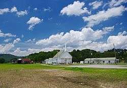 Mount Nebo Baptist Church in Hollytree | |
 Hollytree  Hollytree | |
| Coordinates: 34°47′56″N 86°15′12″W / 34.79889°N 86.25333°WCoordinates: 34°47′56″N 86°15′12″W / 34.79889°N 86.25333°W | |
| Country | United States |
| State | Alabama |
| County | Jackson |
| Elevation | 669 ft (204 m) |
| Time zone | UTC-6 (Central (CST)) |
| • Summer (DST) | UTC-5 (CDT) |
| ZIP code | 35751 |
| Area code(s) | 256 & 938 |
| GNIS feature ID | 156488[1] |
Hollytree is an unincorporated community in Jackson County, Alabama, United States. It is located on Alabama State Route 65, 9.7 miles (15.6 km) northeast of Gurley in the Paint Rock Valley. Hollytree has a post office with ZIP code 35751.[2][3]
References
- ↑ "Hollytree". Geographic Names Information System. United States Geological Survey.
- ↑ United States Postal Service (2012). "USPS - Look Up a ZIP Code". Retrieved 2012-02-15.
- ↑ "Postmaster Finder - Post Offices by ZIP Code". United States Postal Service. Retrieved June 4, 2013.
Municipalities and communities of Jackson County, Alabama, United States | ||
|---|---|---|
| Cities | 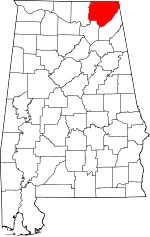 | |
| Towns | ||
| Unincorporated communities | ||
| Ghost towns | ||
This article is issued from
Wikipedia.
The text is licensed under Creative Commons - Attribution - Sharealike.
Additional terms may apply for the media files.