Paint Rock River
| Paint Rock River | |
|---|---|
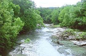 The Paint Rock River near Woodville, Alabama | |
| Physical characteristics | |
| Main source | 34°53′53″N 86°10′14″W / 34.89814°N 86.17053°W |
| River mouth | 34°28′34″N 86°28′04″W / 34.47620°N 86.46776°WCoordinates: 34°28′34″N 86°28′04″W / 34.47620°N 86.46776°W |
The Paint Rock River is a 58.7-mile-long (94.5 km)[1] tributary of the Tennessee River in northern Alabama in the United States. Its tributaries also drain a portion of south-central Tennessee.[2]
The river is formed in northeastern Jackson County by the confluence of Estill Fork and Hurricane Creek, and flows generally southwardly, past the town of Paint Rock. In its upper course, the river flows through a deep valley cut into the Cumberland Plateau. In its lower course, the river is used to define part of the boundary between Madison and Marshall Counties.
See also
References
- ↑ "The National Map". U.S. Geological Survey. Retrieved Feb 23, 2011.
- ↑ U.S. Geological Survey Geographic Names Information System: Paint Rock River
- DeLorme (1998). Alabama Atlas & Gazetteer. Yarmouth, Maine: DeLorme. ISBN 0-89933-274-9.
- U.S. Geological Survey Geographic Names Information System: Paint Rock River
External links
This article is issued from
Wikipedia.
The text is licensed under Creative Commons - Attribution - Sharealike.
Additional terms may apply for the media files.