Deeping St Nicholas
| Deeping Saint Nicholas | |
|---|---|
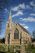 Deeping St Nicholas church | |
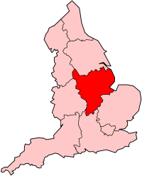
 Deeping Saint Nicholas Deeping Saint Nicholas shown within Lincolnshire | |
| Population | 1,961 (2011)[1] |
| OS grid reference | TF215160 |
| Civil parish |
|
| District | |
| Shire county | |
| Region | |
| Country | England |
| Sovereign state | United Kingdom |
| Post town | SPALDING |
| Postcode district | PE11 3 |
| Dialling code | 01775 63 |
| Police | Lincolnshire |
| Fire | Lincolnshire |
| Ambulance | East Midlands |
| EU Parliament | East Midlands |
| UK Parliament | |
Deeping St Nicholas, near Spalding in Lincolnshire, England is a village on the A1175 road between The Deepings and Spalding. Unlike Market Deeping, which is in South Kesteven district, Deeping St Nicholas is in South Holland.
Deeping St Nicholas is also a South Holland civil parish[2][3] which includes the small settlements of Tongue End and Hop Pole, and a number of outlying farms. It has a total population of 1,323, increasing at the 2011 Census to 1,961.
Village
The village has a 19th-century stone church, the parish church of St Nicholas. The ecclesiastical parish is part of the Elloe West Deanery of the Diocese of Lincoln. There is no incumbent.[4] It is part of the South Lincolnshire Circuit of the Methodist Church
At 7 miles (11.3 km) long, the village has the distinction of being the longest in the United Kingdom.
The whole civil parish falls within the drainage area of the Welland and Deepings Internal Drainage Board.[5]
At the Western end of the village is a level crossing for the Lincoln - Peterborough railway line, the site of the former Littleworth railway station. The goods shed there was used for agricultural produce, including transshipment from the narrow gauge potato railway that also crossed the road.
A Primary School opened on 2 January 1877 with a roll of 5 under a Mr Hanley. The current head teacher, Anita Bandey, oversees over 50 children.[6]
In 2008, eight large wind turbines, the blades of which are 42 metres (137.8 ft) in length, were constructed on land to the north of the settlement.
History
In the 1086 Domesday Book, the village is written as "Estdeping".[7]
From John Marius Wilson's 1872 Imperial Gazetteer of England and Wales:
- DEEPING FEN, a fen and a chapelry in Bourn district, Lincoln. The fen lies on the North Drove and the South Drove drains, between Market-Deeping and Spalding; and comprises upwards of 30,000 acres. About one-half consists of enclosed commons, included in parishes; and the rest is extra-parochial. The chapelry comprises the extra-parochial part; was constituted in 1846; bears the alternative name of Deeping-St. Nicholas; lies adjacent to North Drove railway station, and 5 miles WSW of Spalding; and has a post office, of the name of Deeping-St. Nicholas, under Spalding. Acres, 16, 290. Real property, £27, 681. Pop., 1, 180. Houses, 184. The living is a vicarage in the diocese of Lincoln. Value, £210. Patrons, the Trustees of the late W. Stevenson, Esq. The church was built in 1846.
The Church of St Nicholas was built in 1846, when a new parish was formed to supersede the former chapel of ease of Spalding. The church was built by Charles Kirk, an architect from Sleaford,[8] in Decorated style common in older surrounding churches.
Businesses
Most employment remains in agriculture. Other businesses are:
- D Steele (farming)
- Vine House farm shop
- J A Watts (Mareham) Ltd (farming)
- J Woodhead (farming)
References
- ↑ "Parish population 2011". Retrieved 23 August 2015.
- ↑ "Civil Parish details".
- ↑ "Parish council noticeboard".
- ↑ "Ecclesiastical parish details".
- ↑ "Welland and Deepings IDB".
- ↑ "Primary School web site".
- ↑ Mills, A. D. (1991). A Dictionary of English Place-Names. Oxford University Press.
- ↑ "Church History". Archived from the original on 2011-07-28.
External links
![]()
| Power stations |
|  | ||||||||||||||||||||||||||||
|---|---|---|---|---|---|---|---|---|---|---|---|---|---|---|---|---|---|---|---|---|---|---|---|---|---|---|---|---|---|---|
| Organisations | ||||||||||||||||||||||||||||||
England Portal | |
| Unitary authorities | |
| Boroughs or districts | |
| Major settlements |
|
| Topics | |