Kupferzell
| Kupferzell | ||
|---|---|---|
| ||
 Kupferzell Location of Kupferzell within Hohenlohekreis district 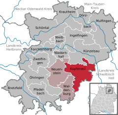  | ||
| Coordinates: 49°14′N 9°41′E / 49.233°N 9.683°ECoordinates: 49°14′N 9°41′E / 49.233°N 9.683°E | ||
| Country | Germany | |
| State | Baden-Württemberg | |
| Admin. region | Stuttgart | |
| District | Hohenlohekreis | |
| Municipal assoc. | Hohenloher Ebene | |
| Government | ||
| • Mayor | Joachim Schaaf | |
| Area | ||
| • Total | 54.28 km2 (20.96 sq mi) | |
| Elevation | 340 m (1,120 ft) | |
| Population (2017-12-31)[1] | ||
| • Total | 6,087 | |
| • Density | 110/km2 (290/sq mi) | |
| Time zone | CET/CEST (UTC+1/+2) | |
| Postal codes | 74635 | |
| Dialling codes | 07944 | |
| Vehicle registration | KÜN | |
| Website | www.kupferzell.de | |

Kupferzell is a town in the district of Hohenlohe in Baden-Württemberg, Germany. The largest neighbouring towns are Künzelsau (to the north) and Schwäbisch Hall (to the south). The town is named after the Kupfer river that flows through it.
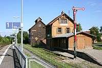
Kupferzell old station, now at Wackershofen open air museum
Sons and daughters of the town
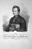
Alexander Hohenlohe around 1825
- Prince Alexander of Hohenlohe-Waldenburg-Schillingsfürst (1794-1849), Catholic priest
- Eberhard Finckh, (1899-1944), career officer and resistance fighter of the 20th July 1944
- Alexander Heath, (born 1991), basketball player
Towns and municipalities in Hohenlohe (district) | ||
|---|---|---|
References
- ↑ "Bevölkerung nach Nationalität und Geschlecht am 31. Dezember 2017". Statistisches Landesamt Baden-Württemberg (in German). 2018.
This article is issued from
Wikipedia.
The text is licensed under Creative Commons - Attribution - Sharealike.
Additional terms may apply for the media files.