Hoglinns Water
| Hoglinns Water | |
|---|---|
 | |
| Location | Hoy, Orkney, Scotland |
| Coordinates | 58°48′08″N 3°18′01″W / 58.80222°N 3.30028°WCoordinates: 58°48′08″N 3°18′01″W / 58.80222°N 3.30028°W[1] |
| Type | Freshwater loch |
| Primary outflows | Hoglinns Burn |
| Basin countries | Scotland |
| Max. length | 0.33 mi (0.53 km)[2] |
| Max. width | 0.2 mi (0.32 km)[2] |
| Surface area | 63 ha (0.24 sq mi)[1] |
| Average depth | 26 ft (7.9 m)[2] |
| Max. depth | 57 ft (17 m)[2] |
| Water volume | 44,000,000 cu ft (1,200,000 m3)[2] |
| Shore length1 | 1.6 km (0.99 mi)[1] |
| Surface elevation | 98 m (322 ft)[1] |
| 1 Shore length is not a well-defined measure. | |
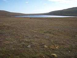
Hoglinns Water is a small freshwater loch in the south of the island of Hoy, Orkney. It drains in to Heldale Water via Hoglinns Burn. The loch was surveyed[2] in 1906 by Sir John Murray and later charted[3] as part of the Bathymetrical Survey of Fresh-Water Lochs of Scotland 1897-1909. [4]
References
- 1 2 3 4 "Hoglinns Water". British Lakes. Retrieved 2013-12-07.
- 1 2 3 4 5 6 "Bathymetrical Survey of the Fresh-Water Lochs of Scotland, 1897-1909, Lochs of Orkney". National Library of Scotland. Retrieved 2013-12-07.
- ↑ "Muckle & Peerie Waters; Loch of Skaill; Hoglinns Water - Bathymetrical Survey, 1897-1909 - National Library of Scotland". National Library of Scotland. Retrieved 2013-12-07.
- ↑ Murray, John; Pullar, Laurence (1910). Bathymetrical Survey of Fresh-Water Lochs of Scotland during the years 1897 to 1909: report on scientific results. Edinburgh.
This article is issued from
Wikipedia.
The text is licensed under Creative Commons - Attribution - Sharealike.
Additional terms may apply for the media files.