Hlyboka Raion
| Hlyboka Raion Глибоцький район | |||
|---|---|---|---|
| Raion | |||
| |||
 | |||
| Coordinates: 48°4′23″N 25°57′33″E / 48.07306°N 25.95917°ECoordinates: 48°4′23″N 25°57′33″E / 48.07306°N 25.95917°E | |||
| Country |
| ||
| Region |
| ||
| Established | N/A | ||
| Admin. center | Hlyboka | ||
| Subdivisions |
List
| ||
| Government | |||
| • Governor | N/A | ||
| Area | |||
| • Total | 673 km2 (260 sq mi) | ||
| Population | |||
| • Total | 74,054 | ||
| • Density | 110/km2 (280/sq mi) | ||
| Time zone | UTC+2 (EET) | ||
| • Summer (DST) | UTC+3 (EEST) | ||
| Postal index | 604-XX | ||
| Area code | 380-3734X | ||
| Website | Official website | ||

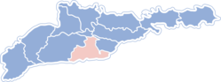
Hlyboka Raion (Ukrainian: Глибоцький район, Romanian: Raionul Adâncata pronounced [raˈjonul adɨŋˈkata]) is an administrative district of Chernivtsi Oblast in western Ukraine. The administrative center is the urban-type settlement of Hlyboka. There are 37 villages in the raion. The population of the raion according to the 2001 Census was 72,682 inhabitants,[1] its area covers 686 square kilometres (265 sq mi). Current population: 74,054 (2015 est.)[2]
In Hlyboka Raion there are 46 secondary schools. Among them, in 25 schools students acquire education in the Ukrainian language, in 20 schools in Romanian, and in one in Russian. There is also one vocational school.
According to the Ukraine Census (2001), the 72,676 residents of the raion reported themselves as following: Ukrainians: 34,025, Romanians: 32,923, Moldovans: 4,425, Russians: 877, and other: 426.
The Raion has also 34 public hospitals and clinics.
See also
References
- ↑ http://www.statoids.com/yua.html
- ↑ "Чисельність наявного населення України (Actual population of Ukraine)" (PDF) (in Ukrainian). State Statistics Service of Ukraine. Retrieved 1 July 2016.
External links
- (in Ukrainian) bucoda.cv.ua - Official website
- (in Ukrainian) Chernivtsi Oblast Nationalities
- (in Ukrainian) Verkhovna Rada website - Administrative divisions of the Hlybotskyi Raion
| Raions | |||||
|---|---|---|---|---|---|
| Cities |
| ||||
| |||||