Jackson, California
| City of Jackson | |
|---|---|
| City | |
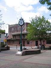
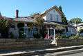
 Historic downtown Jackson | |
| Motto(s): "Preserving our past, enriching our present, building our future" | |
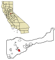 Location of Jackson in Amador County, California. | |
 City of Jackson Location in the United States | |
| Coordinates: 38°20′56″N 120°46′27″W / 38.34889°N 120.77417°WCoordinates: 38°20′56″N 120°46′27″W / 38.34889°N 120.77417°W | |
| Country |
|
| State |
|
| County | Amador |
| Settled | 1848 |
| County Seat, Amador County | 1854 |
| Incorporated | December 5, 1905[1] |
| Government | |
| • Mayor | Pat Crew[2] |
| • Vice Mayor | Connie Gonsalves[2] |
| • State Senate | Tom Berryhill (R)[3] |
| • State Assembly | Frank Bigelow (R)[4] |
| • U. S. Congress | Tom McClintock (R)[5] |
| Area[6] | |
| • Total | 3.59 sq mi (9.30 km2) |
| • Land | 3.59 sq mi (9.30 km2) |
| • Water | 0.00 sq mi (0.00 km2) 0% |
| Elevation[7] | 1,217 ft (371 m) |
| Population (2010) | |
| • Total | 4,651 |
| • Estimate (2016)[8] | 4,678 |
| • Density | 1,302.70/sq mi (502.98/km2) |
| Time zone | UTC-8 (PST) |
| • Summer (DST) | UTC-7 (PDT) |
| ZIP code | 95642 |
| Area code(s) | 209 |
| FIPS code | 06-36980 |
| GNIS feature IDs | 1658849, 2410128 |
| Website |
www |
| Reference no. | 118 |
Jackson (formerly, Botilleas, Botilleas Spring, Bottileas, Bottle Spring,[9] and Botellas)[10] is the county seat of Amador County, California. The population was 4,651 at the 2010 census, up from 3,989 at the 2000 census. The city is accessible by both State Route 49 and State Route 88.
Geography and geology
According to the United States Census Bureau, the city has a total area of 3.7 square miles (9.6 km2), all of it land. Jackson Creek traverses the city. Alluvial soils such as Pardee Cobbly Loam is found throughout the Jackson area.
History
Early history
The area was inhabited by the Northern Sierra Indians, who occupied areas along creeks, spring and seep areas, including permanent and seasonal drainages, flat ridges and terraces. Therefore, areas along watercourses are considered likely locations for prehistoric cultural resources. Permanent villages were usually placed on elevations above seasonal flood levels. Surrounding areas were used for hunting and seed, acorn, and grass gathering.
Recent history
Jackson, named after Colonel Alden Jackson, was founded in 1848 around a year-round spring. Settlement of the region by American pioneers was stimulated by the discovery of gold in the Sierra foothills around 1848. The settlement was named for a local lawyer who was liked by miners named Alden Appola Moore Jackson. Although Amador County was an important mining center, its County seat of Jackson was not typical of the early gold camps. The camp grew quickly, as besides being a popular mining spot, it was also a convenient stopping place on the road from Sacramento to the Southern Mines. The camp became an important supply and transportation center for the neighboring towns, and by 1850 the population had reached an estimated 1,500. Jackson grew first as a watering hole for cattle, then as one of the earliest and most durable of the Mother Lode's hard rock mining areas. In 1853, Jackson became the county seat of newly formed Amador County, California. Previously, from 1851–1852, it had been the county seat of Calaveras County.
Placer mining gave out by the 1860s, replaced by hard rock mining. One of the town's most prominent historical landmarks, the Kennedy Mine, began operation in 1860; at the time of its closure during World War II in 1942, it was the deepest gold mine in North America, at 1802 meters; (5912 ft). On August 27, 1922 47 miners became trapped when a fire broke out in the Argonaut mine. All 47 men died in the fire but it wasn't until over a year later that the last body was recovered. The Argonaut mine incident was the worst gold mine disaster in US history.
In Oct, 1942 the US government passed the War Production Board Limitation Order which signaled the demise of gold mining in California. The government needed men for the war and gold was not considered a strategic war metal.
Landmarks
- Argonaut and Kennedy Mines: California Historical Landmark No. 786.[12]
- Jackson Gate: Jackson Gate, on the north fork of Jackson Creek, takes its name from a fissure in a reef of rock that crosses the creek. In 1850 about 500 miners worked here and the first mining ditch in the county was dug here; its water sold for $1 per inch, CHL No. 118.[13]
- Site of Jackson's Pioneer Jewish Synagogue: On September 18, 1857, Congregation B'nai Israel of Jackson dedicated on this site the first synagogue in the Mother Lode. High holy day worship continued until 1869 when the larger Masonic Hall was used to accommodate the congregation. The wooden structure then served as a schoolhouse until 1888. Relocated onto a nearby lot, it became a private dwelling, and was razed in 1948, CHL No. 865.[14]
- Pioneer Hall: The Order of Native Daughters of the Golden West was organized on these premises, the site of the Pioneer Hall, on September 11, 1886, CHL No. 34.[15]
National Register of Historic Places gallery
Jackson has several buildings listed on the National Register of Historic Places; several are noted below.
 Amador County Hospital Building
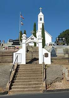
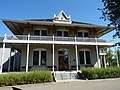
 Grace Blair DePue House and Indian Museum
Points of interest
The City of Jackson in California is the center of trade and industry in Amador County. The majority of the shopping centers, government offices, and many businesses are located in Jackson and its neighbor town, Martell.
- Amador County Model Railroad Museum – Showcasing our rich railroad, logging and mining history, next to the National Hotel.
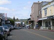
- Jackson Main Street – antique shops, small boutiques and bars. Home to many historic buildings
- Jackson Rancheria – casino and hotel, run by the Jackson Rancheria of Me-Wuk Indians of California
- Underground caves with tours
- Outdoor Activities – camping, picnicking, etc.
Demographics
| Historical population | |||
|---|---|---|---|
| Census | Pop. | %± | |
| 1880 | 1,040 | — | |
| 1910 | 2,035 | — | |
| 1920 | 1,601 | −21.3% | |
| 1930 | 2,005 | 25.2% | |
| 1940 | 2,024 | 0.9% | |
| 1950 | 1,879 | −7.2% | |
| 1960 | 1,852 | −1.4% | |
| 1970 | 1,924 | 3.9% | |
| 1980 | 2,331 | 21.2% | |
| 1990 | 3,545 | 52.1% | |
| 2000 | 3,989 | 12.5% | |
| 2010 | 4,651 | 16.6% | |
| Est. 2016 | 4,678 | [8] | 0.6% |
| U.S. Decennial Census[16] | |||
2010
The 2010 United States Census[17] reported that Jackson had a population of 4,651. The population density was 1,246.9 people per square mile (481.4/km²). The racial makeup of Jackson was 4,090 (87.9%) White, 32 (0.7%) African American, 94 (2.0%) Native American, 60 (1.3%) Asian, 4 (0.1%) Pacific Islander, 185 (4.0%) from other races, and 186 (4.0%) from two or more races. Hispanic or Latino of any race were 520 persons (11.2%).
The Census reported that 4,423 people (95.1% of the population) lived in households, 12 (0.3%) lived in non-institutionalized group quarters, and 216 (4.6%) were institutionalized.
There were 2,065 households, out of which 537 (26.0%) had children under the age of 18 living in them, 822 (39.8%) were opposite-sex married couples living together, 294 (14.2%) had a female householder with no husband present, 98 (4.7%) had a male householder with no wife present. There were 120 (5.8%) unmarried opposite-sex partnerships, and 5 (0.2%) same-sex married couples or partnerships. 747 households (36.2%) were made up of individuals and 438 (21.2%) had someone living alone who was 65 years of age or older. The average household size was 2.14. There were 1,214 families (58.8% of all households); the average family size was 2.75.
The population was spread out with 945 people (20.3%) under the age of 18, 306 people (6.6%) aged 18 to 24, 1,030 people (22.1%) aged 25 to 44, 1,197 people (25.7%) aged 45 to 64, and 1,173 people (25.2%) who were 65 years of age or older. The median age was 46.0 years. For every 100 females, there were 84.1 males. For every 100 females age 18 and over, there were 79.4 males.
There were 2,309 housing units at an average density of 619.0 per square mile (239.0/km²), of which 2,065 were occupied, of which 1,122 (54.3%) were owner-occupied, and 943 (45.7%) were occupied by renters. The homeowner vacancy rate was 4.9%; the rental vacancy rate was 5.8%. 2,305 people (49.6% of the population) lived in owner-occupied housing units and 2,118 people (45.5%) lived in rental housing units.
2000
As of the census[18] of 2000, there were 3,989 people, 1,746 households, and 1,023 families residing in the city. The population density was 1,135.8 people per square mile (438.8/km²). There were 1,859 housing units at an average density of 529.3 per square mile (204.5/km²). The racial makeup of the city was 93.5% White, 0.5% Black or African American, 1.4% Native American, 0.6% Asian, 0.1% Pacific Islander, 1.9% from other races, and 2.1% from two or more races. 6.5% of the population were Hispanic or Latino of any race.
There were 1,746 households out of which 24.0% had children under the age of 18 living with them, 43.8% were married couples living together, 12.0% had a female householder with no husband present, and 41.4% were non-families. 36.1% of all households were made up of individuals and 20.0% had someone living alone who was 65 years of age or older. The average household size was 2.13 and the average family size was 2.74.
In the city, the population was spread out with 20.0% under the age of 18, 6.4% from 18 to 24, 21.9% from 25 to 44, 22.9% from 45 to 64, and 28.8% who were 65 years of age or older. The median age was 47 years. For every 100 females, there were 80.3 males. For every 100 females age 18 and over, there were 75.3 males.
The median income for a household in the city was $35,944, and the median income for a family was $45,887. Males had a median income of $40,444 versus $35,083 for females. The per capita income for the city was $21,399. About 4.1% of families and 8.3% of the population were below the poverty line, including 7.3% of those under age 18 and 7.0% of those age 65 or over.
High school
Jackson has only one high school, Argonaut High School. The school's namesake is the Argonaut Mine, located in town.
Notable people
- Robert Grant Aitken, astronomer
- John C. Begovich, politician
- Anthony Caminetti, politician
- Ernest Gallo, winemaker
References
- ↑ "California Cities by Incorporation Date". California Association of Local Agency Formation Commissions. Archived from the original (Word) on November 3, 2014. Retrieved March 27, 2013.
- 1 2 "City Council Members". City of Jackson. Retrieved March 18, 2013.
- ↑ "Senators". State of California. Retrieved March 18, 2013.
- ↑ "Members Assembly". State of California. Retrieved March 18, 2013.
- ↑ "California's 4th Congressional District - Representatives & District Map". Civic Impulse, LLC. Retrieved March 1, 2013.
- ↑ "2016 U.S. Gazetteer Files". United States Census Bureau. Retrieved Jul 19, 2017.
- ↑ "USGS—Jackson, California". Retrieved 2007-05-24.
- 1 2 "Population and Housing Unit Estimates". Retrieved June 9, 2017.
- ↑ All U.S. Geological Survey Geographic Names Information System: Jackson, California
- ↑ Durham, David L. (1998). California's Geographic Names: A Gazetteer of Historic and Modern Names of the State. Clovis, Calif.: Word Dancer Press. p. 504. ISBN 1-884995-14-4.
- ↑ , Judicial Council of California, Accessed August 2, 2009.
- ↑ "Argonaut and Kennedy mines". Office of Historic Preservation, California State Parks. Retrieved 2012-03-30.
- ↑ "Jackson Gate". Office of Historic Preservation, California State Parks. Retrieved 2012-03-30.
- ↑ "Site of Jackson's Pioneer Jewish Synagogue". Office of Historic Preservation, California State Parks. Retrieved 2012-03-30.
- ↑ "Pioneer Hall". Office of Historic Preservation, California State Parks. Retrieved 2012-03-30.
- ↑ "Census of Population and Housing". Census.gov. Archived from the original on May 12, 2015. Retrieved June 4, 2015.
- ↑ "2010 Census Interactive Population Search: CA – Jackson city". U.S. Census Bureau. Retrieved July 12, 2014.
- ↑ "American FactFinder". United States Census Bureau. Archived from the original on September 11, 2013. Retrieved 2008-01-31.
- C. Michael Hogan, Gary Deghi et al., Scottsville Project Environmental Impact Report, Jackson California, Earth Metrics Inc., Report 7562, Sept., 1989
- "Amador". California Historical Landmarks. Office of Historic Preservation. Retrieved 2005-09-16.
- U.S. Geological Survey Geographic Names Information System: Jackson, California
External links
| Wikimedia Commons has media related to Jackson, California. |
Municipalities and communities of Amador County, California, United States | ||
|---|---|---|
| Cities |  | |
| CDPs | ||
| Unincorporated communities | ||
| Ghost towns |
| |
| Footnotes | ‡This CDP also has portions in an adjacent county or counties | |