Arkansas Highway 300
| ||||
|---|---|---|---|---|
 | ||||
| Route information | ||||
| Maintained by ArDOT | ||||
| Section 1 | ||||
| Length | 34.11 mi[1] (54.89 km) | |||
| West end |
| |||
| East end |
| |||
| Section 2 | ||||
| Length | 1.45 mi[1] (2.33 km) | |||
| West end |
| |||
| East end |
| |||
| Location | ||||
| Counties | Perry, Pulaski | |||
| Highway system | ||||
| ||||

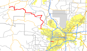
Highway 300 (AR 300, Ark. 300 and Hwy. 300) is a designation for two state highway segments in Central Arkansas. The main route of 34.11 miles (54.89 km)[1] runs from Highway 9/Highway 10 east to Cantrell Road in Little Rock.[2] A second segment runs 1.45 miles (2.33 km) east from Interstate 430 as Colonel Glenn Road.[3]
Route description
Perryville to Little Rock
The main route begins at Highway 9/Highway 10 south of Perryville and runs east along the northern edge of the Harris Brake State Wildlife Management Area. Highway 300 forms a quasi-concurrency[4] south with Highway 216 to Antioch before continuing east through the communities of Oakgrove and Pleasant Valley to Highway 113. After a brief quasi-concurrency south with Highway 113 where it climbs Wye Mountain, the route becomes very rural. Highway 300 skirts Lake Maumelle, the Ouachita National Recreation Trail, the Arkansas River, and Pinnacle Mountain State Park crossing both the Big and Little Maumelle Rivers (as well as the Pegasus Pipeline) while serving many unincorporated communities including Wye, Little Italy, Monnie Springs, Roland, Natural Steps, and Pinnacle before terminating at Cantrell Road in Little Rock near the base of Shinall Mountain. Immediately prior to this terminus, Highway 300 intersects Chenal Parkway, a mostly divided four-lane thoroughfare, which connects the route to Little Rock's Financial Centre District.
Old Ledwidge Spur
In Little Italy, Highway 300 Spur follows Ross Hollow Road eastward and terminates at its intersection with Ledwedge Road. Formerly, the spur continued north along Ledwedge Road toward the community of Ledwidge near the Little Rock and Western Railway and the Arkansas River. Servicing Ledwidge was likely the original purpose of this branch of Highway 300.
Arkansas River Trail
Between its northern quasi-concurrent split with Highway 113 at the base of Wye Mountain and its intersection with Roland Cutoff Road near Lundsford Corner, Highway 300 is designated as part of the Arkansas River Trail. Highway 300 reacquires this designation at its intersection with Henry Street in Roland and carries it south until it intersects Pinnacle Valley Road at Pinnacle Mountain State Park.
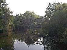
Big Maumelle River Truss Bridge
In the 1920s, a one-lane truss bridge was built on Highway 300 to cross the Big Maumelle River. The bridge still stands in the shadow of Pinnacle Mountain, but was made obsolete by a new bridge in 1981. Today, it is only open to pedestrians for fishing and hiking. It is part of the Ouachita National Recreation Trail and is visible from the current bridge.
Colonel Glenn Road
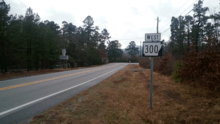
The second segment of Highway 300 begins at Interstate 430 and runs east as Colonel Glenn Road. The route runs to Highway 5, which maintains the Colonel Glenn Road designation north and is named Stagecoach Road to the south. Highway 300 had an Average daily traffic (ADT) of 15000 vehicles in 2010 near its eastern terminus.[1]
Major intersections
| County | Location | mi[1] | km | Destinations | Notes | ||
|---|---|---|---|---|---|---|---|
| Perry | Harris Brake State Wildlife Management Area | 0.00 | 0.00 | Western terminus; near Perryville | |||
| Antioch | 3.83– 5.50 | 6.16– 8.85 | Quasi-concurrency | ||||
| Wye Mountain | 10.50– 13.61 | 16.90– 21.90 | Quasi-concurrency | ||||
| Perry–Pulaski county line | Little Italy | 18.10 | 29.13 | No longer marked | |||
| Pulaski | Little Rock | 34.11 | 54.89 | Eastern terminus | |||
| Highway 300 ends at AR 10 | |||||||
| Gap in AR 300 | |||||||
| Highway 300 begins at I-430 | |||||||
| 0.00 | 0.00 | I-430 exit 4; western terminus. | |||||
| 1.45 | 2.33 | Eastern terminus | |||||
| 1.000 mi = 1.609 km; 1.000 km = 0.621 mi | |||||||
See also
Notes and References
- 1 2 3 4 5 Planning and Research Division (2010). "Arkansas Road Log Database". Arkansas State Highway and Transportation Department. Archived from the original (Database) on 23 June 2011. Retrieved June 9, 2011.
- ↑ General Highway Map (PDF) (Map) (Perry County ed.). Arkansas State Highway and Transportation Department. Archived (PDF) from the original on 18 July 2011. Retrieved June 26, 2011.
- ↑ General Highway Map (PDF) (Map) (Pulaski County ed.). Arkansas State Highway and Transportation Department. Archived (PDF) from the original on 7 July 2011. Retrieved June 26, 2011.
- ↑ Historically, this segment of Highway 300 ran continuously. However, modern-day Arkansas Department of Transportation guidelines has eliminated most state highway concurrencies, and sectioning has become the rule. Consequently, this main segment of Highway 300 now exists as three disjointed sections while still functioning as a continuous route. For the purposes of this article, former true concurrencies are referred to as "quasi-concurrencies" with regard to their history and function as well as the current aforementioned guidelines
External links
Route map:
![]()