Arkansas Highway 141
| ||||
|---|---|---|---|---|
 | ||||
| Route information | ||||
| Maintained by ArDOT | ||||
| Section 1 | ||||
| Length | 2.08 mi[1] (3.35 km) | |||
| South end | Culberhouse Street in Jonesboro | |||
| North end | Parker Road in Jonesboro | |||
| Section 2 | ||||
| Length | 51.68 mi[1] (83.17 km) | |||
| South end | Main Street in Jonesboro | |||
| North end |
| |||
| Location | ||||
| Counties | Craighead, Greene, Clay | |||
| Highway system | ||||
| ||||

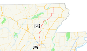
Arkansas Highway 141 is a state highway of 61.1 miles (98.3 km) that runs in Craighead, Greene and Clay Counties.[2][3][4]
Route description
AR 141 begins at Lawson Road south of Jonesboro near Craighead Forest Park. It runs north to meet US 49/US 63/AR 18, forming a concurrency with US 49 through downtown. Once AR 141 leaves US 49 it becomes North Church Street, running north to Philadelphia. AR 141 continues north to Lake Frierson State Park near Loredo. AR 141 runs with AR 168 after Loredo until Walcott and Crowley's Ridge State Park. Continuing north, AR 141 crosses US 412 before entering Beech Grove, where the route meets AR 34. The route then angles east to Hooker, meeting AR 135. AR 141 continues to wind northeast, meeting with AR 90 angling due north. The route crosses US 62 south of McDougal and terminates at Dale Street in McDougal.
Major intersections
| County | Location | mi[1] | km | Destinations | Notes | ||
|---|---|---|---|---|---|---|---|
| Craighead | Jonesboro | 0.00 | 0.00 | Culberhouse Street | Southern terminus | ||
| 2.08 | 3.35 | Parker Road | Northern terminus | ||||
| Gap in route | |||||||
| 0.00 | 0.00 | Main Street | Southern terminus | ||||
| | Begin CRP overlap | ||||||
| Greene | | Begin AR 168 overlap | |||||
| | AR 358 east terminus | ||||||
| | End AR 168/CRR overlaps | ||||||
| | 17.43 | 28.05 | |||||
| | |||||||
| Hooker | 33.62 | 54.11 | Begin CRP overlap | ||||
| Clay | | 44.49– 0.00 | 71.60– 0.00 | ||||
| McDougal | 7.19 | 11.57 | Northern terminus | ||||
1.000 mi = 1.609 km; 1.000 km = 0.621 mi
| |||||||
See also
References
- 1 2 3 System Information and Research Division (2014). "Arkansas Road Log Database" (MDB). Arkansas State Highway and Transportation Department. Retrieved March 27, 2016.
- ↑ Arkansas State Highway and Transportation Department. AHTD Craighead County map Retrieved on June 11, 2009.
- ↑ Arkansas State Highway and Transportation Department. AHTD Greene County map Retrieved on June 11, 2009.
- ↑ Arkansas State Highway and Transportation Department. AHTD Clay County map Retrieved on June 11, 2009.
External links
Route map:
![]()