Walcott, Arkansas
| Walcott, Arkansas | |
|---|---|
| Unincorporated community | |
 Walcott  Walcott | |
| Coordinates: 36°02′36″N 90°40′16″W / 36.04333°N 90.67111°WCoordinates: 36°02′36″N 90°40′16″W / 36.04333°N 90.67111°W | |
| Country | United States |
| State | Arkansas |
| County | Greene |
| Elevation | 338 ft (103 m) |
| Time zone | UTC-6 (Central (CST)) |
| • Summer (DST) | UTC-5 (CDT) |
| ZIP code | 72474 |
| Area code(s) | 870 |
| GNIS feature ID | 58811[1] |
Walcott is an unincorporated community in Greene County, Arkansas, United States. Walcott is located at the junction of Arkansas highways 141 and 168, 10 miles (16 km) west of Paragould. Walcott has a post office with ZIP code 72474.[2]
References
Municipalities and communities of Greene County, Arkansas, United States | ||
|---|---|---|
| Cities | 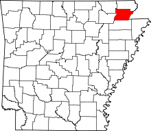 | |
| Towns | ||
| Unincorporated communities | ||
This article is issued from
Wikipedia.
The text is licensed under Creative Commons - Attribution - Sharealike.
Additional terms may apply for the media files.