Higashi-fuchū Station
Higashi-Fuchū Station 東府中駅 | |
|---|---|
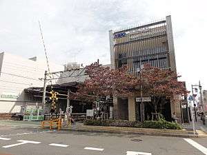 Higashi-Fuchū Station, South exit, October 2010 | |
| Location |
1-8-3 Shimizugaoka, Fuchū-shi, Tokyo (東京都府中市清水が丘一丁目8-3) Japan |
| Operated by |
|
| Line(s) | |
| Platforms | 1 side platform + 1 island platform |
| Tracks | 4 |
| Other information | |
| Station code | KO23 |
| History | |
| Opened | 1916 |
| Previous names | Rinji Keibajomae Station (to 1940) |
| Traffic | |
| Passengers (FY2013) | 20,169 |
Higashi-Fuchū Station (東府中駅 Higashi-Fuchū-ek) is a railway station in Fuchū, Tokyo, Japan, operated by the private railway operator Keio Corporation.[1]
Lines
Higashi-Fuchū Station is served by the Keio Line and the Keiō Keibajō Line. It is located 20.4 km from the Keiō Line's Tokyo terminus at Shinjuku.,[2] and is a terminus of the Keiō Keibajō Line.
Station layout
This station consists of one island platform and one side platform serving four tracks, with an elevated station building located above.
Platforms
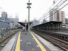
Tracks and platforms of Higashi-Fuchū Station, April 2007
| 1 | ■ Keiō Keibajō Line | for Fuchū-Keiba-Seimon-mae (weekdays) |
| 2 | ■ Keiō Line | for Keiō Hachiōji, Keio Takao Line to Takaosanguchi, and Keio Dobutsuen Line to Tama-Dōbutsukōen |
| ■ Keiō Keibajō Line | for Fuchō-Keiba-Seimon-mae (weekends) | |
| 3 | ■ Keiō Line | for Keiō Hachiōji, Keio Takao Line to Takaosanguchi, and Keio Dobutsuen Line to Tama-Dōbutsukōen |
| 4 | ■ Keiō Line | for Chōfu, Meidaimae, Sasazuka, Shinjuku, and Toei Shinjuku Line |
Adjacent stations
| « | Service | » | ||
|---|---|---|---|---|
| Keiō Line | ||||
| Keiō Liner: Does not stop at this station | ||||
| Special Express: Does not stop at this station | ||||
| Semi Special Express: Does not stop at this station | ||||
| Chōfu | Express | Fuchū | ||
| Chōfu | Semi Express | Fuchū | ||
| Tama-Reien | Rapid | Fuchū | ||
| Tama-Reien | Local | Fuchū | ||
| Keiō Keibajō Line | ||||
| Semi Special Express: Does not stop at this station | ||||
| Chōfu | Express | Fuchū-Keiba-Seimon-mae | ||
| Terminus | Local | Fuchū-Keiba-Seimon-mae | ||
History
The station opened on 12 November 1935.[2] as Rinji Keibajomae Station (臨時競馬場前駅). It was renamed to its present name on 26 October 1940.
Surrounding area
See also
References
- ↑ Keio Railway Map
- 1 2 Terada, Hirokazu (July 2002). データブック日本の私鉄 [Databook: Japan's Private Railways]. Japan: Neko Publishing. p. 205. ISBN 4-87366-874-3.
External links
| Wikimedia Commons has media related to Higashi-Fuchū Station. |
- Keio station information (in Japanese)
Coordinates: 35°40′08″N 139°29′43″E / 35.6689°N 139.4953°E
This article is issued from
Wikipedia.
The text is licensed under Creative Commons - Attribution - Sharealike.
Additional terms may apply for the media files.