Hibbard, Arizona
| Hibbard, Arizona | |
|---|---|
| Populated place | |
 Hibbard Location within the state of Arizona  Hibbard Hibbard (the US) | |
| Coordinates: 34°58′12″N 110°31′56″W / 34.97000°N 110.53222°WCoordinates: 34°58′12″N 110°31′56″W / 34.97000°N 110.53222°W | |
| Country | United States |
| State | Arizona |
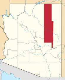
| County | Navajo |
| Elevation[1] | 4,951 ft (1,509 m) |
| Time zone | UTC-7 (Mountain (MST)) |
| • Summer (DST) | UTC-7 (MST) |
| Area code(s) | 928 |
| FIPS code | 04-32580 |
| GNIS feature ID | 24458 |
Hibbard is a populated place situated in Navajo County, Arizona.[2] It lies approximately eight miles west of Canyon Diablo, along the main line of the Atchison, Topeka and Santa Fe Railway. Named after I.L. Hibbard, who was the general superintendent of the railroad.[3] Hibbard has an estimated elevation of 4,951 feet (1,509 m) above sea level.[1]
References
- 1 2 "Feature Detail Report for: Hibbard". Geographic Names Information System. United States Geological Survey.
- ↑ "Hibbard (in Navajo County, AZ) Populated Place Profile". AZ Hometown Locator. Retrieved November 25, 2016.
- ↑ Barnes, Will Croft (2016). Arizona Place Names. Tucson: Arizona Place Names. p. 206. ISBN 0816534950. Archived from the original on November 26, 2016.
This article is issued from
Wikipedia.
The text is licensed under Creative Commons - Attribution - Sharealike.
Additional terms may apply for the media files.