Heil, North Dakota
| Heil, North Dakota | |
|---|---|
| Census-designated place | |
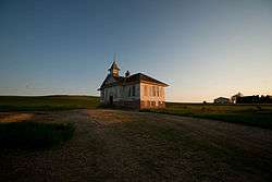 Building in Heil | |
 Heil  Heil | |
| Coordinates: 46°23′15″N 101°42′00″W / 46.38750°N 101.70000°WCoordinates: 46°23′15″N 101°42′00″W / 46.38750°N 101.70000°W | |
| Country | United States |
| State | North Dakota |
| County | Grant |
| Area[1] | |
| • Total | 0.200 sq mi (0.52 km2) |
| • Land | 0.200 sq mi (0.52 km2) |
| • Water | 0 sq mi (0 km2) |
| Elevation | 2,316 ft (706 m) |
| Population (2010)[2] | |
| • Total | 15 |
| • Density | 75/sq mi (29/km2) |
| Time zone | UTC-7 (Mountain (MST)) |
| • Summer (DST) | UTC-6 (MDT) |
| Area code(s) | 701 |
| GNIS feature ID | 1029386[3] |
Heil is a census-designated place and unincorporated community in Grant County, North Dakota, United States. Its population was 15 as of the 2010 census.[2] Heil was initially named "Lawther" for founder William Lawther; after William Heil bought the community from Lawther, it was renamed to "Heil".[3]
References
- ↑ "US Gazetteer files: 2010, 2000, and 1990". United States Census Bureau. 2011-02-12. Retrieved 2011-04-23.
- 1 2 "American FactFinder". United States Census Bureau. Retrieved 2011-05-14.
- 1 2 "Heil". Geographic Names Information System. United States Geological Survey.
Municipalities and communities of Grant County, North Dakota, United States | ||
|---|---|---|
| Cities | 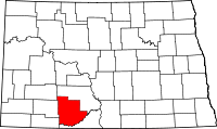 | |
| Townships |
| |
| CDPs | ||
| Unorganized territories |
| |
| Unincorporated communities | ||
| Ghost town | ||
| Counties |  | |
|---|---|---|
| Core cities | ||
| Surrounding areas |
| |
This article is issued from
Wikipedia.
The text is licensed under Creative Commons - Attribution - Sharealike.
Additional terms may apply for the media files.