Moffit, North Dakota
| Moffit, North Dakota | |
|---|---|
| Unincorporated community | |
 Moffit  Moffit | |
| Coordinates: 46°40′39″N 100°17′42″W / 46.67750°N 100.29500°WCoordinates: 46°40′39″N 100°17′42″W / 46.67750°N 100.29500°W | |
| Country | United States |
| State | North Dakota |
| County | Burleigh |
| Time zone | UTC-6 (Central (CST)) |
| • Summer (DST) | UTC-5 (CDT) |
| ZIP codes | 58560 |
| Area code(s) | 701 |
Moffit is an unincorporated community in Burleigh County, North Dakota, United States.[1] It lies along US 83 10 miles south of Sterling. Moffit's ZIP code is 58560.
A post office called Moffit has been in operation since 1906.[2] The community's name honors a family of settlers.[3] In the early 2010's one of the last business buildings left on main street was stripped and torn down for unknown reasons. There is also another building on main street of unknown origin that, in 2017, the front was cut into and it was turned into a storage building. Today, only a bar and post office remain in operation. The population in 2017 was estimated to be less than 30.
References
- ↑ U.S. Geological Survey Geographic Names Information System: Moffit, North Dakota
- ↑ "Burleigh County". Jim Forte Postal History. Retrieved 25 October 2015.
- ↑ Federal Writers' Project (1938). North Dakota, a Guide to the Northern Prairie State,. WPA. p. 209. ISBN 978-1-62376-033-5.
External links
Municipalities and communities of Burleigh County, North Dakota, United States | ||
|---|---|---|
| Cities | 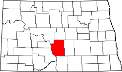 | |
| Townships |
| |
| CDPs | ||
| Unorganized territories |
| |
| Unincorporated communities | ||
| Ghost town | ||
| Footnotes | ‡This populated place also has portions in an adjacent county or counties | |
| Counties |  | |
|---|---|---|
| Core cities | ||
| Surrounding areas |
| |
This article is issued from
Wikipedia.
The text is licensed under Creative Commons - Attribution - Sharealike.
Additional terms may apply for the media files.