Healy, Kansas
| Healy, Kansas | |
|---|---|
| census-designated place | |
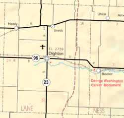 KDOT map of Lane County (legend) | |
| Coordinates: 38°36′0″N 100°37′2″W / 38.60000°N 100.61722°WCoordinates: 38°36′0″N 100°37′2″W / 38.60000°N 100.61722°W[1] | |
| Country | United States |
| State | Kansas |
| County | Lane |
| Elevation[1] | 2,766 ft (843 m) |
| Time zone | UTC-6 (CST) |
| • Summer (DST) | UTC-5 (CDT) |
| ZIP code | 67850 |
| Area code | 620 |
| FIPS code | 20-31200 [1] |
| GNIS feature ID | 0471471 [1] |

Healy is an unincorporated community and census-designated place in Lane County, Kansas, United States.[1]
History
Healy was a station and shipping point on the Missouri Pacific Railroad.[2]
The first post office in Healy was established in 1887.[3]
Geography
Healy is located in Cheyenne Township[4] on K-4 16 miles (26 km) east of the highway's western end at U.S. Route 83.[5]
Climate
According to the Köppen Climate Classification system, Healy has a semi-arid climate, abbreviated "BSk" on climate maps.[6]
Education
Healy Public Schools is a K-12 school. Their mascot is "The Eagles", and offer basketball and track, collaborating with Ransom, KS to form an eight-man football team. Since the 2012-2013 season, the Healy High School basketball team holds a record of 5-97, and according to MaxPreps, is ranked as the second worst team in the state of Kansas, just ahead of the Kansas School for the Deaf in Olathe, as of the end of the 2015-2016 season.[7] Healy has since ended their boys and girls basketball teams.
At the end of the 2013-2014 school year, Healy became the smallest public school in the state of Kansas, and as of the 2017-2018 school year, the enrollment dropped to below 50 K-12 students.[8]
According to the Kansas State High School Activities Association, Healy High School had the lowest enrollment of all its members in the 2018-19 school year at 14.[9]
Notable people
- Harold Ensley - American radio and television personality best known for his television program The Sportsman's Friend.
References
- 1 2 3 4 5 Geographic Names Information System (GNIS) details for Healy, Kansas; United States Geological Survey (USGS); October 13, 1978.
- ↑ Blackmar, Frank Wilson (1912). Kansas: A Cyclopedia of State History, Embracing Events, Institutions, Industries, Counties, Cities, Towns, Prominent Persons, Etc. Standard Publishing Company. p. 838.
- ↑ "Kansas Post Offices, 1828-1961 (archived)". Kansas Historical Society. Archived from the original on October 9, 2013. Retrieved 12 June 2014.
- ↑ Census Bureau map
- ↑ Official Kansas highway map
- ↑ Climate Summary for Healy, Kansas
- ↑ http://www.maxpreps.com/rankings/basketball/15/state/kansas.htm
- ↑ http://www.hutchnews.com/news/local_state_news/small-school-districts-hang-on-for-life/article_9b649e99-9953-52d6-beff-55b88e83c08a.html
- ↑ 2018-2019 Classifications and Enrollments; KSHSAA.
External links
| Wikimedia Commons has media related to Healy, Kansas. |
- Community of Healy
- USD 468, local school district
- Lane County Map, KDOT
Municipalities and communities of Lane County, Kansas, United States | ||
|---|---|---|
| City | 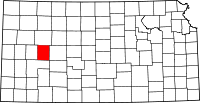 | |
| CDP | ||
| Unincorporated communities | ||